
| Sahara | |
|---|---|

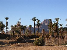
The Sahara taken by Apollo 17 astronauts, 1972 |
|

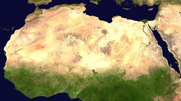
Geographical map of the Sahara |
|
| Length | 4,800 km (3,000 mi) |
| Width | 1,800 km (1,100 mi) |
| Area | 9,200,000 km2 (3,600,000 sq mi) |
| Naming | |
| Native name |
|
| Geography | |
| Countries |
List
|
| Coordinates | 23°N 13°E / 23°N 13°ECoordinates: 23°N 13°E / 23°N 13°E |
The Sahara (, ) is a desert on the African continent. With an area of 9,200,000 square kilometres (3,600,000 sq mi), it is the largest hot desert in the world and the third-largest desert overall, smaller only than the deserts of Antarctica and the northern Arctic.[1][2][3]
The name «Sahara» is derived from the Arabic word for «desert» in the feminine irregular form, the singular ṣaḥra’ (صحراء /ˈsˤaħra/), plural ṣaḥārā (صَحَارَى /ˈsˤaħaːraː/),[4][5][6][7] ṣaḥār (صَحَار), ṣaḥrāwāt (صَحْرَاوَات), ṣaḥāriy (صَحَارِي).
The desert comprises much of North Africa, excluding the fertile region on the Mediterranean Sea coast, the Atlas Mountains of the Maghreb, and the Nile Valley in Egypt and the Sudan. It stretches from the Red Sea in the east and the Mediterranean in the north to the Atlantic Ocean in the west, where the landscape gradually changes from desert to coastal plains. To the south it is bounded by the Sahel, a belt of semi-arid tropical savanna around the Niger River valley and the Sudan region of sub-Saharan Africa. The Sahara can be divided into several regions, including the western Sahara, the central Ahaggar Mountains, the Tibesti Mountains, the Aïr Mountains, the Ténéré desert, and the Libyan Desert.
For several hundred thousand years, the Sahara has alternated between desert and savanna grassland in a 20,000-year cycle[8] caused by the precession of Earth’s axis as it rotates around the Sun, which changes the location of the North African monsoon.
Geography

The main biomes in Africa

The Sahara covers large parts of Algeria, Chad, Egypt, Libya, Mali, Mauritania, Morocco, Niger, Western Sahara, Sudan and Tunisia. It covers 9 million square kilometres (3,500,000 sq mi), amounting to 31% of Africa. If all areas with a mean annual precipitation of less than 250 mm were included, the Sahara would be 11 million square kilometres (4,200,000 sq mi). It is one of three distinct physiographic provinces of the African massive physiographic division. Sahara is so large and bright that, in theory, it could be detected from other stars as a surface feature of Earth, with near-current technology.[9]
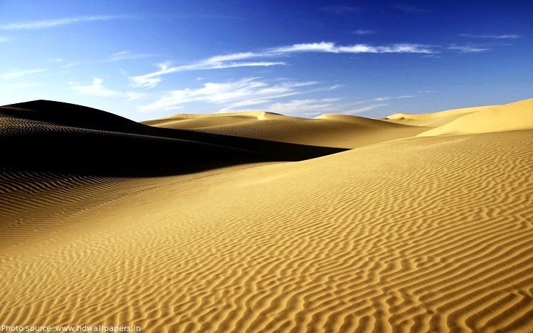
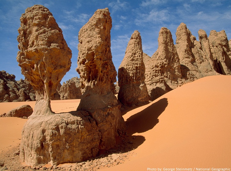
The Sahara is mainly rocky hamada (stone plateaus); ergs (sand seas – large areas covered with sand dunes) form only a minor part, but many of the sand dunes are over 180 metres (590 ft) high.[10] Wind or rare rainfall shape the desert features: sand dunes, dune fields, sand seas, stone plateaus, gravel plains (reg), dry valleys (wadi), dry lakes (oued), and salt flats (shatt or chott).[11] Unusual landforms include the Richat Structure in Mauritania.
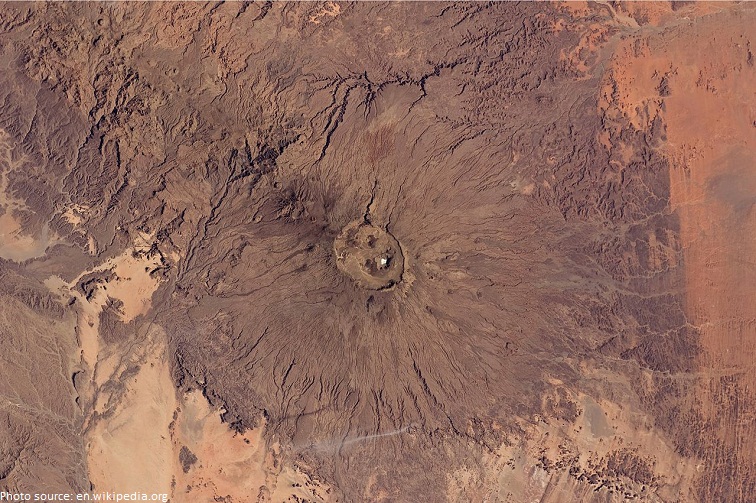
Several deeply dissected mountains, many volcanic, rise from the desert, including the Aïr Mountains, Ahaggar Mountains, Saharan Atlas, Tibesti Mountains, Adrar des Iforas, and the Red Sea Hills. The highest peak in the Sahara is Emi Koussi, a shield volcano in the Tibesti range of northern Chad.
The central Sahara is hyperarid, with sparse vegetation. The northern and southern reaches of the desert, along with the highlands, have areas of sparse grassland and desert shrub, with trees and taller shrubs in wadis, where moisture collects. In the central, hyperarid region, there are many subdivisions of the great desert: Tanezrouft, the Ténéré, the Libyan Desert, the Eastern Desert, the Nubian Desert and others. These extremely arid areas often receive no rain for years.
To the north, the Sahara skirts the Mediterranean Sea in Egypt and portions of Libya, but in Cyrenaica and the Maghreb, the Sahara borders the Mediterranean forest, woodland, and scrub eco-regions of northern Africa, all of which have a Mediterranean climate characterized by hot summers and cool and rainy winters. According to the botanical criteria of Frank White[12] and geographer Robert Capot-Rey,[13][14] the northern limit of the Sahara corresponds to the northern limit of date palm cultivation and the southern limit of the range of esparto, a grass typical of the Mediterranean climate portion of the Maghreb and Iberia. The northern limit also corresponds to the 100 mm (3.9 in) isohyet of annual precipitation.[15]
To the south, the Sahara is bounded by the Sahel, a belt of dry tropical savanna with a summer rainy season that extends across Africa from east to west. The southern limit of the Sahara is indicated botanically by the southern limit of Cornulaca monacantha (a drought-tolerant member of the Chenopodiaceae), or northern limit of Cenchrus biflorus, a grass typical of the Sahel.[13][14] According to climatic criteria, the southern limit of the Sahara corresponds to the 150 mm (5.9 in) isohyet of annual precipitation (this is a long-term average, since precipitation varies annually).[15]
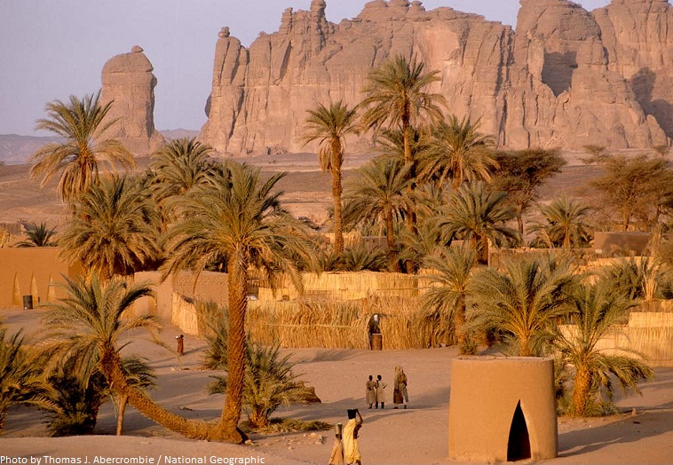
Important cities located in the Sahara include Nouakchott, the capital of Mauritania; Tamanrasset, Ouargla, Béchar, Hassi Messaoud, Ghardaïa, and El Oued in Algeria; Timbuktu in Mali; Agadez in Niger; Ghat in Libya; and Faya-Largeau in Chad.
Climate
The Sahara is the world’s largest hot desert.[16] It is located in the horse latitudes under the subtropical ridge, a significant belt of semi-permanent subtropical warm-core high pressure where the air from the upper troposphere usually descends, warming and drying the lower troposphere and preventing cloud formation.[citation needed]
The permanent absence of clouds allows unhindered light and thermal radiation. The stability of the atmosphere above the desert prevents any convective overturning, thus making rainfall virtually non-existent. As a consequence, the weather tends to be sunny, dry and stable with a minimal chance of rainfall. Subsiding, diverging, dry air masses associated with subtropical high-pressure systems are extremely unfavorable for the development of convectional showers. The subtropical ridge is the predominant factor that explains the hot desert climate (Köppen climate classification BWh) of this vast region. The descending airflow is the strongest and the most effective over the eastern part of the Great Desert, in the Libyan Desert: this is the sunniest, driest and the most nearly «rainless» place on the planet, rivaling the Atacama Desert, lying in Chile and Peru.
The rainfall inhibition and the dissipation of cloud cover are most accentuated over the eastern section of the Sahara rather than the western. The prevailing air mass lying above the Sahara is the continental tropical (cT) air mass, which is hot and dry. Hot, dry air masses primarily form over the North-African desert from the heating of the vast continental land area, and it affects the whole desert during most of the year. Because of this extreme heating process, a thermal low is usually noticed near the surface, and is the strongest and the most developed during the summertime. The Sahara High represents the eastern continental extension of the Azores High,[citation needed] centered over the North Atlantic Ocean. The subsidence of the Sahara High nearly reaches the ground during the coolest part of the year, while it is confined to the upper troposphere during the hottest periods.
The effects of local surface low pressure are extremely limited because upper-level subsidence still continues to block any form of air ascent. Also, to be protected against rain-bearing weather systems by the atmospheric circulation itself, the desert is made even drier by its geographical configuration and location. Indeed, the extreme aridity of the Sahara is not only explained by the subtropical high pressure: the Atlas Mountains of Algeria, Morocco and Tunisia also help to enhance the aridity of the northern part of the desert. These major mountain ranges act as a barrier, causing a strong rain shadow effect on the leeward side by dropping much of the humidity brought by atmospheric disturbances along the polar front which affects the surrounding Mediterranean climates.
The primary source of rain in the Sahara is the Intertropical Convergence Zone, a continuous belt of low-pressure systems near the equator which bring the brief, short and irregular rainy season to the Sahel and southern Sahara. Rainfall in this giant desert has to overcome the physical and atmospheric barriers that normally prevent the production of precipitation. The harsh climate of the Sahara is characterized by: extremely low, unreliable, highly erratic rainfall; extremely high sunshine duration values; high temperatures year-round; negligible rates of relative humidity; a significant diurnal temperature variation; and extremely high levels of potential evaporation which are the highest recorded worldwide.[17]
Temperature
The sky is usually clear above the desert, and the sunshine duration is extremely high everywhere in the Sahara. Most of the desert has more than 3,600 hours of bright sunshine per year (over 82% of daylight hours), and a wide area in the eastern part has over 4,000 hours of bright sunshine per year (over 91% of daylight hours). The highest values are very close to the theoretical maximum value. A value of 4300 hours (98%) of the time would be[clarification needed] recorded in Upper Egypt (Aswan, Luxor) and in the Nubian Desert (Wadi Halfa).[18] The annual average direct solar irradiation is around 2,800 kWh/(m2 year) in the Great Desert. The Sahara has a huge potential for solar energy production.

The high position of the Sun, the extremely low relative humidity, and the lack of vegetation and rainfall make the Great Desert the hottest large region in the world, and the hottest place on Earth during summer in some spots. The average high temperature exceeds 38 to 40 °C or 100.4 to 104.0 °F during the hottest month nearly everywhere in the desert except at very high altitudes. The world’s highest officially recorded average daily high temperature[clarification needed] was 47 °C or 116.6 °F in a remote desert town in the Algerian Desert called Bou Bernous, at an elevation of 378 metres (1,240 ft) above sea level,[18] and only Death Valley, California rivals it.[19] Other hot spots in Algeria such as Adrar, Timimoun, In Salah, Ouallene, Aoulef, Reggane with an elevation between 200 and 400 metres (660 and 1,310 ft) above sea level get slightly lower summer average highs, around 46 °C or 114.8 °F during the hottest months of the year. Salah, well known in Algeria for its extreme heat, has average high temperatures of 43.8 °C or 110.8 °F, 46.4 °C or 115.5 °F, 45.5 °C or 113.9 °F and 41.9 °C or 107.4 °F in June, July, August and September respectively. There are even hotter spots in the Sahara, but they are located in extremely remote areas, especially in the Azalai, lying in northern Mali. The major part of the desert experiences around three to five months when the average high strictly[clarification needed] exceeds 40 °C or 104 °F; while in the southern central part of the desert, there are up to six or seven months when the average high temperature strictly[clarification needed] exceeds 40 °C or 104 °F. Some examples of this are Bilma, Niger and Faya-Largeau, Chad. The annual average daily temperature exceeds 20 °C or 68 °F everywhere and can approach 30 °C or 86 °F in the hottest regions year-round. However, most of the desert has a value in excess of 25 °C or 77 °F.

Sand and ground temperatures are even more extreme. During daytime, the sand temperature is extremely high: it can easily reach 80 °C or 176 °F or more.[20] A sand temperature of 83.5 °C (182.3 °F) has been recorded in Port Sudan.[20] Ground temperatures of 72 °C or 161.6 °F have been recorded in the Adrar of Mauritania and a value of 75 °C (167 °F) has been measured in Borkou, northern Chad.[20]
Due to lack of cloud cover and very low humidity, the desert usually has high diurnal temperature variations between days and nights. However, it is a myth that the nights are especially cold after extremely hot days in the Sahara.[citation needed] On average, nighttime temperatures tend to be 13–20 °C (23–36 °F) cooler than in the daytime. The smallest variations are found along the coastal regions due to high humidity and are often even lower than a 10 °C or 18 °F difference, while the largest variations are found in inland desert areas where the humidity is the lowest, mainly in the southern Sahara. Still, it is true that winter nights can be cold, as it can drop to the freezing point and even below, especially in high-elevation areas.[clarification needed] The frequency of subfreezing winter nights in the Sahara is strongly influenced by the North Atlantic Oscillation (NAO), with warmer winter temperatures during negative NAO events and cooler winters with more frosts when the NAO is positive.[21] This is because the weaker clockwise flow around the eastern side of the subtropical anticyclone during negative NAO winters, although too dry to produce more than negligible precipitation, does reduce the flow of dry, cold air from higher latitudes of Eurasia into the Sahara significantly.[22]
Precipitation
The average annual rainfall ranges from very low in the northern and southern fringes of the desert to nearly non-existent over the central and the eastern part. The thin northern fringe of the desert receives more winter cloudiness and rainfall due to the arrival of low pressure systems over the Mediterranean Sea along the polar front, although very attenuated by the rain shadow effects of the mountains and the annual average rainfall ranges from 100 millimetres (4 in) to 250 millimetres (10 in). For example, Biskra, Algeria, and Ouarzazate, Morocco, are found in this zone. The southern fringe of the desert along the border with the Sahel receives summer cloudiness and rainfall due to the arrival of the Intertropical Convergence Zone from the south and the annual average rainfall ranges from 100 millimetres (4 in) to 250 millimetres (10 in). For example, Timbuktu, Mali and Agadez, Niger are found in this zone. The vast central hyper-arid core of the desert is virtually never affected by northerly or southerly atmospheric disturbances and permanently remains under the influence of the strongest anticyclonic weather regime, and the annual average rainfall can drop to less than 1 millimetre (0.04 in). In fact, most of the Sahara receives less than 20 millimetres (0.8 in). Of the 9,000,000 square kilometres (3,500,000 sq mi) of desert land in the Sahara, an area of about 2,800,000 square kilometres (1,100,000 sq mi) (about 31% of the total area) receives an annual average rainfall amount of 10 millimetres (0.4 in) or less, while some 1,500,000 square kilometres (580,000 sq mi) (about 17% of the total area) receives an average of 5 millimetres (0.2 in) or less.[23] The annual average rainfall is virtually zero over a wide area of some 1,000,000 square kilometres (390,000 sq mi) in the eastern Sahara comprising deserts of: Libya, Egypt and Sudan (Tazirbu, Kufra, Dakhla, Kharga, Farafra, Siwa, Asyut, Sohag, Luxor, Aswan, Abu Simbel, Wadi Halfa) where the long-term mean approximates 0.5 millimetres (0.02 in) per year.[23] Rainfall is very unreliable and erratic in the Sahara as it may vary considerably year by year. In full contrast to the negligible annual rainfall amounts, the annual rates of potential evaporation are extraordinarily high, roughly ranging from 2,500 millimetres (100 in) per year to more than 6,000 millimetres (240 in) per year in the whole desert.[24] Nowhere else on Earth has air been found as dry and evaporative as in the Sahara region. However, at least two instances of snowfall have been recorded in Sahara, in February 1979 and December 2016, both in the town of Ain Sefra.[25]
Desertification and prehistoric climate
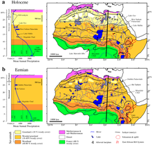
Vegetation and water bodies in the Eemian (bottom) and early Holocene (top)
One theory for the formation of the Sahara is that the monsoon in Northern Africa was weakened because of glaciation during the Quaternary period, starting two or three million years ago. Another theory is that the monsoon was weakened when the ancient Tethys Sea dried up during the Tortonian period around 7 million years.[26]
The climate of the Sahara has undergone enormous variations between wet and dry over the last few hundred thousand years,[27] believed to be caused by long-term changes in the North African climate cycle that alters the path of the North African Monsoon – usually southward. The cycle is caused by a 41,000-year cycle in which the tilt of the earth changes between 22° and 24.5°.[23] At present, we are in a dry period, but it is expected that the Sahara will become green again in 15,000 years. When the North African monsoon is at its strongest, annual precipitation and subsequent vegetation in the Sahara region increase, resulting in conditions commonly referred to as the «green Sahara». For a relatively weak North African monsoon, the opposite is true, with decreased annual precipitation and less vegetation resulting in a phase of the Sahara climate cycle known as the «desert Sahara».[28]
The idea that changes in insolation (solar heating) caused by long-term changes in Earth’s orbit are a controlling factor for the long-term variations in the strength of monsoon patterns across the globe was first suggested by Rudolf Spitaler in the late nineteenth century,[29] The hypothesis was later formally proposed and tested by the meteorologist John Kutzbach in 1981.[30] Kutzbach’s ideas about the impacts of insolation on global monsoonal patterns have become widely accepted today as the underlying driver of long-term monsoonal cycles. Kutzbach never formally named his hypothesis and as such it is referred to here as the «Orbital Monsoon Hypothesis» as suggested by Ruddiman in 2001.[29]

During the last glacial period, the Sahara was much larger than it is today, extending south beyond its current boundaries.[31] The end of the glacial period brought more rain to the Sahara, from about 8000 BCE to 6000 BCE, perhaps because of low pressure areas over the collapsing ice sheets to the north.[32] Once the ice sheets were gone, the northern Sahara dried out. In the southern Sahara, the drying trend was initially counteracted by the monsoon, which brought rain further north than it does today. By around 4200 BCE, however, the monsoon retreated south to approximately where it is today,[33] leading to the gradual desertification of the Sahara.[34] The Sahara is now as dry as it was about 13,000 years ago.[27]
Lake Chad is the remnant of a former inland sea, paleolake Mega-Chad, which existed during the African humid period. At its largest extent, sometime before 5000 BCE, Lake Mega-Chad was the largest of four Saharan paleolakes, and is estimated to have covered an area of 350,000 km2.[35]
The Sahara pump theory describes this cycle. During periods of a wet or «Green Sahara», the Sahara becomes a savanna grassland and various flora and fauna become more common. Following inter-pluvial arid periods, the Sahara area then reverts to desert conditions and the flora and fauna are forced to retreat northwards to the Atlas Mountains, southwards into West Africa, or eastwards into the Nile Valley. This separates populations of some of the species in areas with different climates, forcing them to adapt, possibly giving rise to allopatric speciation.
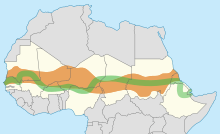
The Great Green Wall, participating countries and Sahel. In September 2020, it was reported that the GGW had only covered 4% of the planned area.[36]
It is also proposed that humans accelerated the drying-out period from 6000 to 2500 BCE by pastoralists overgrazing available grassland.[37]
Evidence for cycles
The growth of speleothems (which requires rainwater) was detected in Hol-Zakh, Ashalim, Even-Sid, Ma’ale-ha-Meyshar, Ktora Cracks, Nagev Tzavoa Cave, and elsewhere, and has allowed tracking of prehistoric rainfall. The Red Sea coastal route was extremely arid before 140 and after 115 kya (thousands of years ago). Slightly wetter conditions appear at 90–87 kya, but it still was just one tenth the rainfall around 125 kya. In the southern Negev Desert speleothems did not grow between 185 and 140 kya (MIS 6), 110–90 (MIS 5.4–5.2), nor after 85 kya nor during most of the interglacial period (MIS 5.1), the glacial period and Holocene. This suggests that the southern Negev was arid-to-hyper-arid in these periods.[38]
During the Last Glacial Maximum (LGM) the Sahara desert was more extensive than it is now with the extent of the tropical forests being greatly reduced,[39] and the lower temperatures reduced the strength of the Hadley Cell. This is a climate cell which causes rising tropical air of the Inter-Tropical Convergence Zone (ITCZ) to bring rain to the tropics, while dry descending air, at about 20 degrees north, flows back to the equator and brings desert conditions to this region. It is associated with high rates of wind-blown mineral dust, and these dust levels are found as expected in marine cores from the north tropical Atlantic. But around 12,500 BCE the amount of dust in the cores in the Bølling/Allerød phase suddenly plummets and shows a period of much wetter conditions in the Sahara, indicating a Dansgaard-Oeschger (DO) event (a sudden warming followed by a slower cooling of the climate). The moister Saharan conditions had begun about 12,500 BCE, with the extension of the ITCZ northward in the northern hemisphere summer, bringing moist wet conditions and a savanna climate to the Sahara, which (apart from a short dry spell associated with the Younger Dryas) peaked during the Holocene thermal maximum climatic phase at 4000 BCE when mid-latitude temperatures seem to have been between 2 and 3 degrees warmer than in the recent past. Analysis of Nile River deposited sediments in the delta also shows this period had a higher proportion of sediments coming from the Blue Nile, suggesting higher rainfall also in the Ethiopian Highlands. This was caused principally by a stronger monsoonal circulation throughout the sub-tropical regions, affecting India, Arabia and the Sahara.[citation needed] Lake Victoria only recently became the source of the White Nile and dried out almost completely around 15 kya.[40]
The sudden subsequent movement of the ITCZ southwards with a Heinrich event (a sudden cooling followed by a slower warming), linked to changes with the El Niño-Southern Oscillation cycle, led to a rapid drying out of the Saharan and Arabian regions, which quickly became desert. This is linked to a marked decline in the scale of the Nile floods between 2700 and 2100 BCE.[41]
Ecoregions
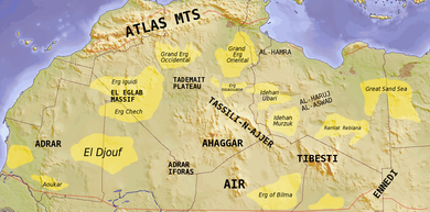
The major topographic features of the Saharan region
The Sahara comprises several distinct ecoregions. With their variations in temperature, rainfall, elevation, and soil, these regions harbor distinct communities of plants and animals.
- The Atlantic coastal desert is a narrow strip along the Atlantic coast where fog generated offshore by the cool Canary Current provides sufficient moisture to sustain a variety of lichens, succulents, and shrubs. It covers an area of 39,900 square kilometers (15,400 sq mi) in the south of Morocco and Mauritania.[42]
- The North Saharan steppe and woodlands is along the northern desert, next to the Mediterranean forests, woodlands, and scrub ecoregions of the northern Maghreb and Cyrenaica. Winter rains sustain shrublands and dry woodlands that form a transition between the Mediterranean climate regions to the north and the hyper-arid Sahara proper to the south. It covers 1,675,300 square kilometers (646,840 sq mi) in Algeria, Egypt, Libya, Mauritania, Morocco, and Tunisia.[43]
- The Sahara Desert ecoregion covers the hyper-arid central portion of the Sahara where rainfall is minimal and sporadic. Vegetation is rare, and this ecoregion consists mostly of sand dunes (erg, chech, raoui), stone plateaus (hamadas), gravel plains (reg), dry valleys (wadis), and salt flats. It covers 4,639,900 square kilometres (1,791,500 sq mi) of: Algeria, Chad, Egypt, Libya, Mali, Mauritania, Niger, and Sudan.[11]
- The South Saharan steppe and woodlands ecoregion is a narrow band running east and west between the hyper-arid Sahara and the Sahel savannas to the south. Movements of the equatorial Intertropical Convergence Zone (ITCZ) bring summer rains during July and August which average 100 to 200 mm (4 to 8 in) but vary greatly from year to year. These rains sustain summer pastures of grasses and herbs, with dry woodlands and shrublands along seasonal watercourses. This ecoregion covers 1,101,700 square kilometres (425,400 sq mi) in Algeria, Chad, Mali, Mauritania, and Sudan.[44]
- In the West Saharan montane xeric woodlands, several volcanic highlands provide a cooler, moister environment that supports Saharo-Mediterranean woodlands and shrublands. The ecoregion covers 258,100 square kilometres (99,650 sq mi), mostly in the Tassili n’Ajjer of Algeria, with smaller enclaves in the Aïr of Niger, the Adrar Plateau of Mauritania, and the Adrar des Iforas of Mali and Algeria.[45]
- The Tibesti-Jebel Uweinat montane xeric woodlands ecoregion consists of the Tibesti and Jebel Uweinat highlands. Higher and more regular rainfall and cooler temperatures support woodlands and shrublands of date palm, acacias, myrtle, oleander, tamarix, and several rare and endemic plants. The ecoregion covers 82,200 square kilometres (31,700 sq mi) in the Tibesti of Chad and Libya, and Jebel Uweinat on the border of Egypt, Libya, and Sudan.[46]
- The Saharan halophytics is an area of seasonally flooded saline depressions which is home to halophytic (salt-adapted) plant communities. The Saharan halophytics cover 54,000 square kilometres (21,000 sq mi) including: the Qattara and Siwa depressions in northern Egypt, the Tunisian salt lakes of central Tunisia, Chott Melghir in Algeria, and smaller areas of Algeria, Mauritania, and the southern part of Morocco.[47]
- The Tanezrouft is one of the Sahara’s most arid regions, with no vegetation and very little life. A barren, flat gravel plain, it extends south of Reggane in Algeria towards the Adrar des Ifoghas highlands in northern Mali.
Flora and fauna
The flora of the Sahara is highly diversified based on the bio-geographical characteristics of this vast desert. Floristically, the Sahara has three zones based on the amount of rainfall received – the Northern (Mediterranean), Central and Southern Zones. There are two transitional zones – the Mediterranean-Sahara transition and the Sahel transition zone.[48]
The Saharan flora comprises around 2800 species of vascular plants. Approximately a quarter of these are endemic. About half of these species are common to the flora of the Arabian deserts.[49]
The central Sahara is estimated to include five hundred species of plants, which is extremely low considering the huge extent of the area. Plants such as acacia trees, palms, succulents, spiny shrubs, and grasses have adapted to the arid conditions, by growing lower to avoid water loss by strong winds, by storing water in their thick stems to use it in dry periods, by having long roots that travel horizontally to reach the maximum area of water and to find any surface moisture, and by having small thick leaves or needles to prevent water loss by evapotranspiration. Plant leaves may dry out totally and then recover.
Several species of fox live in the Sahara including: the fennec fox, pale fox and Rüppell’s fox. The addax, a large white antelope, can go nearly a year in the desert without drinking. The dorcas gazelle is a north African gazelle that can also go for a long time without water. Other notable gazelles include the rhim gazelle and dama gazelle.
The Saharan cheetah (northwest African cheetah) lives in Algeria, Togo, Niger, Mali, Benin, and Burkina Faso. There remain fewer than 250 mature cheetahs, which are very cautious, fleeing any human presence. The cheetah avoids the sun from April to October, seeking the shelter of shrubs such as balanites and acacias. They are unusually pale.[50][51] The other cheetah subspecies (northeast African cheetah) lives in Chad, Sudan and the eastern region of Niger. However, it is currently extinct in the wild in Egypt and Libya. There are approximately 2000 mature individuals left in the wild.

Other animals include the monitor lizards, hyrax, sand vipers, and small populations of African wild dog,[52] in perhaps only 14 countries[53] and red-necked ostrich. Other animals exist in the Sahara (birds in particular) such as African silverbill and black-faced firefinch, among others. There are also small desert crocodiles in Mauritania and the Ennedi Plateau of Chad.[54]
The deathstalker scorpion can be 10 cm (3.9 in) long. Its venom contains large amounts of agitoxin and scyllatoxin and is very dangerous; however, a sting from this scorpion rarely kills a healthy adult. The Saharan silver ant is unique in that due to the extreme high temperatures of their habitat, and the threat of predators, the ants are active outside their nest for only about ten minutes per day.[55]
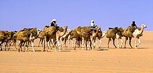
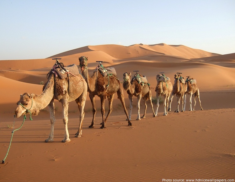
Dromedary camels and goats are the domesticated animals most commonly found in the Sahara. Because of its qualities of endurance and speed, the dromedary is the favourite animal used by nomads.
Human activities are more likely to affect the habitat in areas of permanent water (oases) or where water comes close to the surface. Here, the local pressure on natural resources can be intense. The remaining populations of large mammals have been greatly reduced by hunting for food and recreation. In recent years development projects have started in the deserts of Algeria and Tunisia using irrigated water pumped from underground aquifers. These schemes often lead to soil degradation and salinization.
Researchers from Hacettepe University have reported that Saharan soil may have bio-available iron and also some essential macro and micro nutrient elements suitable for use as fertilizer for growing wheat.[56]
History
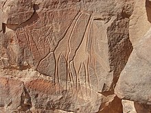
People lived on the edge of the desert thousands of years ago,[57] since the end of the last glacial period. In the Central Sahara, engraved and painted rock art were created perhaps as early as 10,000 years ago, spanning the Bubaline Period, Kel Essuf Period, Round Head Period, Pastoral Period, Caballine Period, and Cameline Period.[58] The Sahara was then a much wetter place than it is today. Over 30,000 petroglyphs of river animals such as crocodiles[59] survive, with half found in the Tassili n’Ajjer in southeast Algeria. Fossils of dinosaurs,[60] including Afrovenator, Jobaria and Ouranosaurus, have also been found here. The modern Sahara, though, is not lush in vegetation, except in the Nile Valley, at a few oases, and in the northern highlands, where Mediterranean plants such as the olive tree are found to grow. It was long believed that the region had been this way since about 1600 BCE, after shifts in Earth’s axis increased temperatures and decreased precipitation, which led to the abrupt desertification of North Africa about 5,400 years ago.[33]
Kiffians
The Kiffian culture is a prehistoric industry, or domain, that existed between 10,000 and 8,000 years ago in the Sahara, during the Neolithic Subpluvial. Human remains from this culture were found in 2000 at a site known as Gobero, located in Niger in the Ténéré Desert.[61] The site is known as the largest and earliest grave of Stone Age people in the Sahara desert.[62] The Kiffians were skilled hunters. Bones of many large savannah animals that were discovered in the same area suggest that they lived on the shores of a lake that was present during the Holocene Wet Phase, a period when the Sahara was verdant and wet.[62] The Kiffian people were tall, standing over six feet in height.[61] Craniometric analysis indicates that this early Holocene population was closely related to the Late Pleistocene Iberomaurusians and early Holocene Capsians of the Maghreb, as well as mid-Holocene Mechta groups.[63] Traces of the Kiffian culture do not exist after 8,000 years ago, as the Sahara went through a dry period for the next thousand years.[64] After this time, the Tenerian culture colonized the area.
Tenerians
Gobero was discovered in 2000 during an archaeological expedition led by Paul Sereno, which sought dinosaur remains. Two distinct prehistoric cultures were discovered at the site: the early Holocene Kiffian culture, and the middle Holocene Tenerian culture. The post-Kiffian desiccation lasted until around 4600 BCE, when the earliest artefacts associated with the Tenerians have been dated to. Some 200 skeletons have been discovered at Gobero. The Tenerians were considerably shorter in height and less robust than the earlier Kiffians. Craniometric analysis also indicates that they were osteologically distinct. The Kiffian skulls are akin to those of the Late Pleistocene Iberomaurusians, early Holocene Capsians, and mid-Holocene Mechta groups, whereas the Tenerian crania are more like those of Mediterranean groups.[65][66] Graves show that the Tenerians observed spiritual traditions, as they were buried with artifacts such as jewelry made of hippo tusks and clay pots. The most interesting find is a triple burial, dated to 5300 years ago, of an adult female and two children, estimated through their teeth as being five and eight years old, hugging each other. Pollen residue indicates they were buried on a bed of flowers. The three are assumed to have died within 24 hours of each other, but as their skeletons hold no apparent trauma (they did not die violently) and they have been buried so elaborately – unlikely if they had died of a plague – the cause of their deaths is a mystery.

Tashwinat Mummy
Uan Muhuggiag appears to have been inhabited from at least the 6th millennium BCE to about 2700 BCE, although not necessarily continuously.[67] The most noteworthy find at Uan Muhuggiag is the well-preserved mummy of a young boy of approximately 2+1⁄2 years old. The child was in a fetal position, then embalmed, then placed in a sack made of antelope skin, which was insulated by a layer of leaves.[68] The boy’s organs were removed, as evidenced by incisions in his stomach and thorax, and an organic preservative was inserted to stop his body from decomposing.[69] An ostrich eggshell necklace was also found around his neck.[67] Radiocarbon dating determined the age of the mummy to be approximately 5600 years old, which makes it about 1000 years older than the earliest previously recorded mummy in ancient Egypt.[70] In 1958–59, an archaeological expedition led by Antonio Ascenzi conducted anthropological, radiological, histological and chemical analyses on the Uan Muhuggiag mummy. The team claimed that the mummy was a 30-month-old child of uncertain sex who possessed Negroid features (Note: «negroid» is derived from a disproven theory of biological race, and modern genetics has since rendered such terminology obsolete).[71][72] A long incision on the specimen’s abdominal wall also indicated that the body had been initially mummified by evisceration and later underwent natural desiccation.[73] A more recent publication referenced a laboratory examination of the cutaneous features of the child mummy in which the results verified that the child possessed a dark skin complexion.[74] One other individual, an adult, was found at Uan Muhuggiag, buried in a crouched position.[67] However, the body showed no evidence of evisceration or any other method of preservation. The body was estimated to date from about 7500 BP.[75]
Nubians

Beni Isguen, a holy city surrounded by thick walls in the Algerian Sahara
During the Neolithic Era, before the onset of desertification around 9500 BCE, the central Sudan had been a rich environment supporting a large population ranging across what is now barren desert, like the Wadi el-Qa’ab. By the 5th millennium BCE, the people who inhabited what is now called Nubia were full participants in the «agricultural revolution», living a settled lifestyle with domesticated plants and animals. Saharan rock art of cattle and herdsmen suggests the presence of a cattle cult like those found in Sudan and other pastoral societies in Africa today.[76] Megaliths found at Nabta Playa are overt examples of probably the world’s first known archaeoastronomy devices, predating Stonehenge by some 2,000 years.[77] This complexity, as observed at Nabta Playa, and as expressed by different levels of authority within the society there, likely formed the basis for the structure of both the Neolithic society at Nabta and the Old Kingdom of Egypt.[78]
Archaeological evidence has attested that population settlements occurred in Nubia as early as the Late Pleistocene era and from the 5th millennium BC onwards, whereas there is «no or scanty evidence» of human presence in the Egyptian Nile Valley during these periods, which may be due to problems in site preservation.[79]
Egyptians
By 6000 BCE predynastic Egyptians in the southwestern corner of Egypt were herding cattle and constructing large buildings. Subsistence in organized and permanent settlements in predynastic Egypt by the middle of the 6th millennium BCE centered predominantly on cereal and animal agriculture: cattle, goats, pigs and sheep. Metal objects replaced prior ones of stone. Tanning of animal skins, pottery and weaving were commonplace in this era also. There are indications of seasonal or only temporary occupation of the Al Fayyum in the 6th millennium BCE, with food activities centering on fishing, hunting and food-gathering. Stone arrowheads, knives and scrapers from the era are commonly found.[80] Burial items included pottery, jewelry, farming and hunting equipment, and assorted foods including dried meat and fruit. Burial in desert environments appears to enhance Egyptian preservation rites, and the dead were buried facing due west.[81] Several scholars have argued that the African origins of the Egyptian civilisation derived from pastoral communities which emerged in both the Egyptian and Sudanese regions of the Nile Valley in the fifth millennium BCE.[82]
By 3400 BCE, the Sahara was as dry as it is today, due to reduced precipitation and higher temperatures resulting from a shift in Earth’s orbit.[33] As a result of this aridification, it became a largely impenetrable barrier to humans, with the remaining settlements mainly being concentrated around the numerous oases that dot the landscape. Little trade or commerce is known to have passed through the interior in subsequent periods, the only major exception being the Nile Valley. The Nile, however, was impassable at several cataracts, making trade and contact by boat difficult.
Tichitt culture
In 4000 BCE, the start of sophisticated social structure (e.g., trade of cattle as valued assets) developed among herders amid the Pastoral Period of the Sahara.[83] Saharan pastoral culture (e.g., fields of tumuli, lustrous stone rings, axes) was intricate.[84] By 1800 BCE, Saharan pastoral culture expanded throughout the Saharan and Sahelian regions.[83] The initial stages of sophisticated social structure among Saharan herders served as the segue for the development of sophisticated hierarchies found in African settlements, such as Dhar Tichitt.[83] After migrating from the Central Sahara, Mande peoples established their civilization in the Tichitt region[85] of the Western Sahara[86] The Tichitt Tradition of eastern Mauritania dates from 2200 BCE[87][88] to 200 BCE.[89][90] Tichitt culture, at Dhar Néma, Dhar Tagant, Dhar Tichitt, and Dhar Walata, included a four-tiered hierarchal social structure, farming of cereals, metallurgy, numerous funerary tombs, and a rock art tradition[91] At Dhar Tichitt and Dhar Walata, pearl millet may have also been independently tamed amid the Neolithic.[92] The urban[86] Tichitt Tradition may have been the earliest large-scale, complexly organized society in West Africa,[93] and an early civilization of the Sahara,[85][87] which may have served as the segue for state formation in West Africa.[84]
As areas where the Tichitt cultural tradition were present, Dhar Tichitt and Dhar Walata were occupied more frequently than Dhar Néma.[93] Farming of crops (e.g., millet) may have been a feature of the Tichitt cultural tradition as early as 3rd millennium BCE in Dhar Tichitt.[93]
As part of a broader trend of iron metallurgy developed in the West African Sahel amid 1st millennium BCE, iron items (350 BCE – 100 CE) were found at Dhar Tagant, iron metalworking and/or items (800 BCE – 400 BCE) were found at Dia Shoma and Walaldé, and the iron remnants (760 BCE – 400 BCE) found at Bou Khzama and Djiganyai.[93] The iron materials that were found are evidence of iron metalworking at Dhar Tagant.[90] In the late period of the Tichitt Tradition at Dhar Néma, tamed pearl millet was used to temper the tuyeres of a oval-shaped low shaft furnace; this furnace was one out of 16 iron furnaces located on elevated ground.[89] Iron metallurgy may have developed before the second half of 1st millennium BCE, as indicated by pottery dated between 800 BCE and 200 BCE.[89] At Dhar Walata and Dhar Tichitt, copper was also used.[86]
After its decline in Mauritania, the Tichitt Tradition spread to the Middle Niger region (e.g., Méma, Macina, Dia Shoma, Jenne Jeno) of Mali where it developed into and persisted as Faïta Facies ceramics between 1300 BCE and 400 BCE among rammed earth architecture and iron metallurgy (which had developed after 900 BCE).[94] Thereafter, the Ghana Empire developed in the 1st millennium CE.[94]
Phoenicians
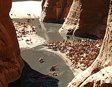
Azalai salt caravan. The French reported that the 1906 caravan numbered 20,000 camels.
The people of Phoenicia, who flourished from 1200 to 800 BCE, created a chain of settlements along the coast of North Africa and traded extensively with its inhabitants. This put them in contact with the people of ancient Libya, who were the ancestors of people who speak Berber languages in North Africa and the Sahara today.
The Libyco-Berber alphabet of the ancient Libyans of north Africa seems to have been based on Phoenician, and its descendant Tifinagh is still used today by the (Berber) Tuareg of the central Sahara.
The Periplus of the Phoenician navigator Hanno, who lived sometime in the 5th century BC, claims that he founded settlements along the Atlantic coast of Africa, possibly including the Western Sahara. The identification of the places discussed is controversial, and archeological confirmation is lacking.
Greeks
By 500 BCE, Greeks arrived in the desert. Greek traders spread along the eastern coast of the desert, establishing trading colonies along the Red Sea. The Carthaginians explored the Atlantic coast of the desert, but the turbulence of the waters and the lack of markets caused a lack of presence further south than modern Morocco. Centralized states thus surrounded the desert on the north and east; it remained outside the control of these states. Raids from the nomadic Berber people of the desert were of constant concern to those living on the edge of the desert.
Urban civilization

Market on the main square of Ghardaïa (1971)
An urban civilization, the Garamantes, arose around 500 BCE in the heart of the Sahara, in a valley that is now called the Wadi al-Ajal in Fezzan, Libya.[27] The Garamantes achieved this development by digging tunnels far into the mountains flanking the valley to tap fossil water and bring it to their fields. The Garamantes grew populous and strong, conquering their neighbors and capturing many slaves (who were put to work extending the tunnels). The ancient Greeks and the Romans knew of the Garamantes and regarded them as uncivilized nomads. However, they traded with them, and a Roman bath has been found in the Garamantes’ capital of Garama. Archaeologists have found eight major towns and many other important settlements in the Garamantes’ territory. The Garamantes’ civilization eventually collapsed after they had depleted available water in the aquifers and could no longer sustain the effort to extend the tunnels further into the mountains.[95]
Between the first century BCE and the fourth century CE, several Roman expeditions into the Sahara were conducted by groups of military and commercial units of Romans.
Berbers


The Tuareg once controlled the central Sahara and its trade.
The Berber people occupied (and still occupy with Arabs) much of the Sahara. The Garamantes Berbers built a prosperous empire in the heart of the desert.[96] The Tuareg nomads continue to inhabit and move across wide Sahara surfaces to the present day.
Islamic and Arabic expansion
The Byzantine Empire ruled the northern shores of the Sahara from the 5th to the 7th centuries. After the Muslim conquest of Arabia, specifically the Arabian peninsula, the Muslim conquest of North Africa began in the mid-7th to early 8th centuries and Islamic influence expanded rapidly on the Sahara. By the end of 641 all of Egypt was in Muslim hands. Trade across the desert intensified, and a significant slave trade crossed the desert. It has been estimated that from the 10th to 19th centuries some 6,000 to 7,000 slaves were transported north each year.[97]
The Beni Ḥassān and other nomadic Arab tribes dominated the Sanhaja Berber tribes of the western Sahara after the Char Bouba war of the 17th century. As a result, Arabian culture and language came to dominate, and the Berber tribes underwent some Arabization.
Ottoman Turkish era
In the 16th century the northern fringe of the Sahara, such as coastal regencies in present-day Algeria and Tunisia, as well as some parts of present-day Libya, together with the semi-autonomous kingdom of Egypt, were occupied by the Ottoman Empire. From 1517 Egypt was a valued part of the Ottoman Empire, ownership of which provided the Ottomans with control over the Nile Valley, the east Mediterranean and North Africa. The benefit of the Ottoman Empire was the freedom of movement for citizens and goods. Traders exploited the Ottoman land routes to handle the spices, gold and silk from the East, manufactured goods from Europe, and the slave and gold traffic from Africa. Arabic continued as the local language and Islamic culture was much reinforced. The Sahel and southern Sahara regions were home to several independent states or to roaming Tuareg clans.
European colonialism
European colonialism in the Sahara began in the 19th century. France conquered the regency of Algiers from the Ottomans in 1830, and French rule spread south from French Algeria and eastwards from Senegal into the upper Niger to include present-day Algeria, Chad, Mali then French Sudan including Timbuktu (1893), Mauritania, Morocco (1912), Niger, and Tunisia (1881). By the beginning of the 20th century, the trans-Saharan trade had clearly declined because goods were moved through more modern and efficient means, such as airplanes, rather than across the desert.[98]
The French took advantage of long-standing animosity between the Chaamba Arabs and the Tuareg. The newly raised Méhariste camel corps were originally recruited mainly from the Chaamba nomadic tribe. In 1902, the French penetrated the Hoggar mountains and defeated Ahaggar Tuareg in the battle of Tit.

The French Colonial Empire was the dominant presence in the Sahara. It established regular air links from Toulouse (HQ of famed Aéropostale), to Oran and over the Hoggar to Timbuktu and West to Bamako and Dakar, as well as trans-Sahara bus services run by La Compagnie Transsaharienne (est. 1927).[99] A remarkable film shot by famous aviator Captain René Wauthier in 1933 documents the first crossing by a large truck convoy from Algiers to Tchad, across the Sahara.[100]
Egypt, under Muhammad Ali and his successors, conquered Nubia in 1820–22, founded Khartoum in 1823, and conquered Darfur in 1874. Egypt, including Sudan, became a British protectorate in 1882. Egypt and Britain lost control of the Sudan from 1882 to 1898 as a result of the Mahdist War. After its capture by British troops in 1898, the Sudan became an Anglo-Egyptian condominium.
Spain captured present-day Western Sahara after 1874, although Rio del Oro remained largely under Sahrawi influence. In 1912, Italy captured parts of what was to be named Libya from the Ottomans. To promote the Roman Catholic religion in the desert, Pope Pius IX appointed a delegate Apostolic of the Sahara and the Sudan in 1868; later in the 19th century his jurisdiction was reorganized into the Vicariate Apostolic of Sahara.
Breakup of the empires and afterwards

A natural rock arch in south western Libya
Egypt became independent of Britain in 1936, although the Anglo-Egyptian treaty of 1936 allowed Britain to keep troops in Egypt and to maintain the British-Egyptian condominium in the Sudan. British military forces were withdrawn in 1954.
Most of the Saharan states achieved independence after World War II: Libya in 1951; Morocco, Sudan, and Tunisia in 1956; Chad, Mali, Mauritania, and Niger in 1960; and Algeria in 1962. Spain withdrew from Western Sahara in 1975, and it was partitioned between Mauritania and Morocco. Mauritania withdrew in 1979; Morocco continues to hold the territory (see Western Sahara conflict).[101]
Tuareg people in Mali rebelled several times during the 20th century before finally forcing the Malian armed forces to withdraw below the line demarcating Azawad from southern Mali during the 2012 rebellion.[102] Islamist rebels in the Sahara calling themselves al-Qaeda in the Islamic Maghreb have stepped up their violence in recent years.[103]
In the post–World War II era, several mines and communities have developed to use the desert’s natural resources. These include large deposits of oil and natural gas in Algeria and Libya, and large deposits of phosphates in Morocco and Western Sahara.[104] Libya’s Great Man-Made River is the world’s largest irrigation project.[105] The project uses a pipeline system that pumps fossil water from the Nubian Sandstone Aquifer System to cities in the populous Libyan northern Mediterranean coast including Tripoli and Benghazi.[106]
A number of Trans-African highways have been proposed across the Sahara, including the Cairo–Dakar Highway along the Atlantic coast, the Trans-Sahara Highway from Algiers on the Mediterranean to Kano in Nigeria, the Tripoli – Cape Town Highway from Tripoli in Libya to N’Djamena in Chad, and the Cairo – Cape Town Highway which follows the Nile. Each of these highways is partially complete, with significant gaps and unpaved sections.
People, culture, and languages
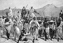
A 19th-century engraving of an Arab slave-trading caravan transporting black African slaves across the Sahara
The people of the Sahara are of various origins. Among them the Amazigh including the Tuareg, various Arabized Amaziɣ groups such as the Hassaniya-speaking Sahrawis, whose populations include the Znaga, a tribe whose name is a remnant of the pre-historic Zenaga language. Other major groups of people include the: Toubou, Nubians, Zaghawa, Kanuri, Hausa, Songhai, Beja, and Fula/Fulani (French: Peul; Fula: Fulɓe). The archaeological evidence from the Holocene period has shown that Nilo-Saharan speaking groups had populated the central and southern Sahara before the influx of Berber and Arabic speakers, around 1500 years ago, who now largely populate the Sahara in the modern era.[107]
Arabic dialects are the most widely spoken languages in the Sahara. Arabic, Berber and its variants now regrouped under the term Amazigh (which includes the Guanche language spoken by the original Berber inhabitants of the Canary Islands) and Beja languages are part of the Afro-Asiatic or Hamito-Semitic family.[citation needed] Unlike neighboring West Africa and the central governments of the states that comprise the Sahara, the French language bears little relevance to inter-personal discourse and commerce within the region, its people retaining staunch ethnic and political affiliations with Tuareg and Berber leaders and culture.[108] The legacy of the French colonial era administration is primarily manifested in the territorial reorganization enacted by the Third and Fourth republics, which engendered artificial political divisions within a hitherto isolated and porous region.[109] Diplomacy with local clients was conducted primarily in Arabic, which was the traditional language of bureaucratic affairs. Mediation of disputes and inter-agency communication was served by interpreters contracted by the French government, who, according to Keenan, «documented a space of intercultural mediation,» contributing much to preserving the indigenous cultural identities in the region.[110]
See also
- African humid period – Holocene climate period during which northern Africa was wetter than today
- Arid Lands Information Network
- List of deserts – List of deserts by continent
- List of deserts by area – List of the largest deserts in the world by area
- List of Saharan explorers
- Sahara Conservation Fund – International conservation organization
- Sahara Sea – Engineering project to flood parts of the Sahara Desert with sea water.
- Trans-Saharan slave trade – Slave trade
Notes
References
- ^ Cook, Kerry H.; Vizy, Edward K. (2015). «Detection and Analysis of an Amplified Warming of the Sahara Desert». Journal of Climate. 28 (16): 6560. Bibcode:2015JCli…28.6560C. doi:10.1175/JCLI-D-14-00230.1.
- ^ «Largest Desert in the World». Retrieved 30 December 2011.
- ^ «Is the World Full or Empty?». Story Maps. Story Maps. Retrieved 19 October 2018.
- ^ «Sahara.» Online Etymology Dictionary. Douglas Harper, Historian. Retrieved 25 June 2007.
- ^ «English-Arabic online dictionary». Online.ectaco.co.uk. 28 December 2006. Retrieved 12 June 2010.
- ^ Wehr, Hans (1994). A Dictionary of Modern Written Arabic (Arabic-English) (4th ed.). Wiesbaden: Otto Harrassowitz. p. 589. ISBN 978-0-87950-003-0.
- ^ al-Ba’labakkī, Rūḥī (2002). al-Mawrid: Qāmūs ‘Arabī-Inklīzī (in Arabic) (16th ed.). Beirut: Dār al-‘Ilm lil-Malāyīn. p. 689.
- ^ Chu, Jennifer (2 January 2019). «A «pacemaker» for North African climate». MIT News. Retrieved 20 January 2020.
- ^ Farr, Ben; Farr, Will M.; Cowan, Nicolas B.; Haggard, Hal M.; Robinson, Tyler (2018). «Exocartographer: A Bayesian Framework for Mapping Exoplanets in Reflected Light». The Astronomical Journal. 156 (4): 146. arXiv:1802.06805. Bibcode:2018AJ….156..146F. doi:10.3847/1538-3881/aad775. S2CID 85443933.
- ^ Strahler, Arthur N. and Strahler, Alan H. (1987) Modern Physical Geography Third Edition. New York: John Wiley & Sons. ISBN 0-471-85064-0. p. 347
- ^ a b «Sahara desert». Terrestrial Ecoregions. World Wildlife Fund. Retrieved 30 December 2007.
- ^ Wickens, Gerald E. (1998) Ecophysiology of Economic Plants in Arid and Semi-Arid Lands. Springer, Berlin. ISBN 978-3-540-52171-6
- ^ a b Grove, A.T.; Nicole (2007) [1958]. «The Ancient Erg of Hausaland, and Similar Formations on the South Side of the Sahara». The Geographical Journal. 124 (4): 528–533. doi:10.2307/1790942. JSTOR 1790942.
- ^ a b Bisson, J. (2003). Mythes et réalités d’un désert convoité: le Sahara (in French). L’Harmattan.
- ^ a b Walton, K. (2007). The Arid Zones. Aldine. ASIN B008MR69VM.
- ^ «The 10 Largest Deserts In The World». WorldAtlas. 13 October 2020. Retrieved 18 January 2022.
- ^ Griffiths, Ieuan L.I. (17 June 2013). The Atlas of African Affairs. Routledge. ISBN 978-1-135-85552-9.
- ^ a b Oliver, John E. (23 April 2008). Encyclopedia of World Climatology. Springer Science & Business Media. ISBN 978-1-4020-3264-6.
- ^ Griffiths, John F.; Driscoll, Dennis M. (1982). Survey of Climatology. C.E. Merrill Publishing Company. ISBN 978-0-675-09994-3.
- ^ a b c Nicholson, Sharon E. (27 October 2011). Dryland Climatology. Cambridge University Press. ISBN 978-1-139-50024-1.
- ^ Visbeck, Martin H.; Hurrell, James W.; Polvani, Lorenzo; Cullen, Heidi M. (6 November 2001). «The North Atlantic Oscillation: Past, present, and future». Proceedings of the National Academy of Sciences. 98 (23): 12876–12877. Bibcode:2001PNAS…9812876V. doi:10.1073/pnas.231391598. ISSN 0027-8424. PMC 60791. PMID 11687629.
- ^ Hurrell, James W.; Kushnir, Yochanan; Ottersen, Geir; Visbeck, Martin (2003), «An Overview of the North Atlantic Oscillation», The North Atlantic Oscillation: Climatic Significance and Environmental Impact, American Geophysical Union (AGU), vol. 134, pp. 1–35, Bibcode:2003GMS…134….1H, doi:10.1029/134gm01, ISBN 978-1-118-66903-7, S2CID 13890714, retrieved 18 January 2022
- ^ a b c Houérou, Henry N. (10 December 2008). Bioclimatology and Biogeography of Africa. Springer Science & Business Media. ISBN 978-3-540-85192-9.
- ^ Brown, G.W. (17 September 2013). Desert Biology: Special Topics on the Physical and Biological Aspects of Arid Regions. Elsevier. ISBN 978-1-4832-1663-8.
- ^ «Snow falls in Sahara for first time in 37 years». CNN. 21 December 2016. Retrieved 22 December 2016.
- ^ Yan, Qing; Contoux, Camille; Camille Li; Schuster, Mathieu; Ramstein, Gilles; Zhang, Zhongshi (17 September 2014). «Aridification of the Sahara desert caused by Tethys Sea shrinkage during the Late Miocene». Nature. 513 (7518): 401–404. Bibcode:2014Natur.513..401Z. doi:10.1038/nature13705. ISSN 1476-4687. PMID 25230661. S2CID 205240355.
- ^ a b c White, Kevin; Mattingly, David J. (2006). «Ancient Lakes of the Sahara». American Scientist. 94 (1): 58–65. doi:10.1511/2006.57.983.
- ^ Foley, Jonathan A.; Coe, Michael T.; Scheffer, Marten; Wang, Guiling (1 October 2003). «Regime Shifts in the Sahara and Sahel: Interactions between Ecological and Climatic Systems in Northern Africa». Ecosystems. 6 (6): 524–539. CiteSeerX 10.1.1.533.5471. doi:10.1007/s10021-002-0227-0. S2CID 12698952.
- ^ a b Ruddiman, William F. (2001). Earth’s Climate: Past and Future. New York: W.H. Freeman and Company. ISBN 978-0-7167-3741-4.
- ^ Kutzbach, J.E. (2 October 1981). «Monsoon Climate of the Early Holocene: Climate Experiment with the Earth’s Orbital Parameters for 9000 Years Ago». Science. 214 (4516): 59–61. Bibcode:1981Sci…214…59K. doi:10.1126/science.214.4516.59. PMID 17802573. S2CID 10388125.
- ^ Ehret, Christopher, The Civilizations of Africa, University Press of Virginia, 2002.
- ^ Fezzan Project — Palaeoclimate and environment. Retrieved 15 March 2006. Archived 7 June 2009 at the Wayback Machine
- ^ a b c Sahara’s Abrupt Desertification Started by Changes in Earth’s Orbit, Accelerated by Atmospheric and Vegetation Feedbacks.
- ^ Kröpelin, Stefan; et al. (2008). «Climate-Driven Ecosystem Succession in the Sahara: The Past 6000 Years» (PDF). Science. 320 (5877): 765–768. Bibcode:2008Sci…320..765K. doi:10.1126/science.1154913. PMID 18467583. S2CID 9045667. Archived from the original (PDF) on 3 March 2016. Retrieved 22 February 2013.
- ^ Quade, J.; Dente, E.; Armon, M.; Ben Dor, Y.; Morin, E.; Adam, O.; Enzel, Y. (2018). «Megalakes in the Sahara? A Review». Quaternary Research. Cambridge University Press. 90 (2): 253–275. Bibcode:2018QuRes..90..253Q. doi:10.1017/qua.2018.46. S2CID 133889170.
- ^ Jonathan Watts (7 September 2020). «Africa’s Great Green Wall just 4% complete halfway through schedule». The Guardian. ISSN 0261-3077 – via www.theguardian.com.
- ^ Boissoneault, Lorraine (24 March 2017). «What Really Turned the Sahara Desert From a Green Oasis into a Wasteland?». Smithsonian. Retrieved 15 August 2017.
- ^ Vaks, Anton; Bar-Matthews, Miryam; Ayalon, Avner; Matthews, Alan; Halicz, Ludwik; Frumkin, Amos (2007). «Desert speleothems reveal climatic window for African exodus of early modern humans» (PDF). Geology. 35 (9): 831. Bibcode:2007Geo….35..831V. doi:10.1130/G23794A.1. Archived from the original (PDF) on 21 July 2011.
- ^ Adams, Jonathan. «Africa during the last 150,000 years». Environmental Sciences Division, ORNL Oak Ridge National Laboratory. Archived from the original on 1 May 2006.
- ^ Stager, J.C.; Johnson, T.C. (2008). «The late Pleistocene desiccation of Lake Victoria and the origin of its endemic biota». Hydrobiologia. 596: 5–16. doi:10.1007/s10750-007-9158-2. S2CID 42372016.
- ^ Burroughs, William J. (2007) «Climate Change in Prehistory: the end of the reign of chaos» (Cambridge University Press)
- ^ «Atlantic coastal desert». Terrestrial Ecoregions. World Wildlife Fund. Retrieved 29 December 2007.
- ^ «North Saharan steppe and woodlands». Terrestrial Ecoregions. World Wildlife Fund. Retrieved 29 December 2007.
- ^ «South Saharan steppe and woodlands». Terrestrial Ecoregions. World Wildlife Fund. Retrieved 29 December 2007.
- ^ «West Saharan montane xeric woodlands». Terrestrial Ecoregions. World Wildlife Fund. Retrieved 29 December 2007.
- ^ «Tibesti-Jebel Uweinat montane xeric woodlands». Terrestrial Ecoregions. World Wildlife Fund. Retrieved 29 December 2007.
- ^ «Saharan halophytics». Terrestrial Ecoregions. World Wildlife Fund. Retrieved 29 December 2007.
- ^ Mares, Michael A., ed. (1999). Encyclopedia of Deserts. University of Oklahoma Press. p. 490. ISBN 978-0-8061-3146-7.
- ^ Houérou, Henry N. (2008). Bioclimatology and Biogeography of Africa. Springer. p. 82. ISBN 978-3-540-85192-9.
- ^ «Rare cheetah captured on camera». BBC News. 24 February 2009. Retrieved 12 June 2010.
- ^ Belbachir, F. (2008). «Acinonyx jubatus ssp. hecki«. IUCN Red List of Threatened Species. 2008: e.T221A13035738. doi:10.2305/IUCN.UK.2008.RLTS.T221A13035738.en. Retrieved 13 November 2021.
- ^ Woodroffe, R.; Sillero-Zubiri, C. (2020). «Lycaon pictus«. IUCN Red List of Threatened Species. 2020: e.T12436A166502262. doi:10.2305/IUCN.UK.2020-1.RLTS.T12436A166502262.en. Retrieved 13 November 2021.
- ^ Borrell, Brendan (19 August 2009). «Endangered in South Africa: Those Doggone Conservationists». Slate. Archived from the original on 30 April 2011.
- ^ «Desert-Adapted Crocs Found in Africa», National Geographic News, 18 June 2002
- ^ Wehner, R.; Marsh, A.C.; Wehner, S. (1992). «Desert ants on a thermal tightrope». Nature. 357 (6379): 586–87. Bibcode:1992Natur.357..586W. doi:10.1038/357586a0. S2CID 11774194.
- ^ Yücekutlu, Nihal; Terzioğlu, Serpil; Saydam, Cemal; Bildacı, Işık (2011). «Organic Farming By Using Saharan Soil: Could It Be An Alternative To Fertilizers?» (PDF). Hacettepe Journal of Biology and Chemistry. 39 (1): 29–38. Retrieved 23 March 2015.[permanent dead link]
- ^ Discover Magazine, 2006-Oct.
- ^ Soukopova, Jitka (2017). «Central Saharan rock art: Considering the kettles and cupules». Journal of Arid Environments. 143: 10. Bibcode:2017JArEn.143…10S. doi:10.1016/j.jaridenv.2016.12.011.
- ^ National Geographic News, 17 June 2006.
- ^ El-Said, Mohammed (29 January 2018). «Near-perfect fossils of Egyptian dinosaur discovered in the Sahara desert». Nature Middle East. doi:10.1038/nmiddleeast.2018.7.
- ^ a b «Stone Age Graveyard Reveals Lifestyles of A ‘Green Sahara’«. Science Daily. 15 August 2008. Retrieved 15 August 2008.
- ^ a b Wilford, John Noble (14 August 2008). «Graves Found From Sahara’s Green Period». The New York Times. Retrieved 15 August 2008.
- ^ Sereno PC, Garcea EAA, Jousse H, Stojanowski CM, Saliège J-F, Maga A, et al. (2008). «Lakeside Cemeteries in the Sahara: 5000 Years of Holocene Population and Environmental Change». PLOS ONE. 3 (8): e2995. Bibcode:2008PLoSO…3.2995S. doi:10.1371/journal.pone.0002995. PMC 2515196. PMID 18701936.
- ^ Schultz, Nora (14 August 2008). «Stone Age mass graves reveal green Sahara». New Scientist. Retrieved 15 August 2008.
- ^ Sereno PC, Garcea EA, Jousse H, Stojanowski CM, Saliège JF, Maga A, et al. (2008). «Lakeside Cemeteries in the Sahara: 5000 Years of Holocene Population and Environmental Change». PLOS ONE. 3 (8): e2995. Bibcode:2008PLoSO…3.2995S. doi:10.1371/journal.pone.0002995. PMC 2515196. PMID 18701936.
- ^ Wilford, John Noble (14 August 2008). «In the Sahara, Stone Age graves from greener days». The New York Times. The New York Times. Retrieved 10 June 2016.
- ^ a b c Mori, F. (1998). The Great Civilisations of the ancient Sahara: Neolithisation and the earliest evidence of anthropomorphic religions. Rome: L’Erma di Bretschneider. ISBN 88-7062-971-6.
- ^ Hooke, C. (Director), & Mosely, G. (Producer) (2003). Black Mummy of the Green Sahara (Discovery Channel).
- ^ Cockburn, A. (1980). Mummies, Disease and Ancient Cultures. Cambridge University Press. ISBN 0-521-23020-9.
- ^ «Wan Muhuggiag». Retrieved 16 November 2015.
- ^ Templeton, A. (2016). «Evolution and Notions of Human Race». In Losos, J.; Lenski, R. (eds.). How Evolution Shapes Our Lives: Essays on Biology and Society. Princeton; Oxford: Princeton University Press. pp. 346–361. doi:10.2307/j.ctv7h0s6j.26
- ^ American Association of Physical Anthropologists (27 March 2019). «AAPA Statement on Race and Racism». American Association of Physical Anthropologists. Retrieved 27 Nov 2021
- ^ V. Giuffra; et al. (2010). «Antonio Ascenzi (1915–2000), a Pathologist devoted to Anthropology and Paleopathology» (PDF). Pathologica. 102 (1): 1–5. PMID 20731247. Archived from the original (PDF) on 25 November 2016. Retrieved 24 November 2016.
- ^ Soukopova, Jitka (16 January 2013). Round Heads: The Earliest Rock Paintings in the Sahara. Cambridge Scholars Publishing. pp. 19–24. ISBN 978-1-4438-4579-3.
- ^ Soukopova, J. (2012). Round Heads: The Earliest Rock Paintings in the Sahara. Newcastle upon Tyne: Cambridge Scholars Publishing. ISBN 978-1-4438-4007-1.
- ^ «History of Nubia». Anth.ucsb.edu. Retrieved 12 June 2010.
- ^ The History of Astronomy. PlanetQuest
- ^ Wendorf, Fred (1998) Late Neolithic megalithic structures at Nabta Playa.
- ^ Gatto, Maria C. «The Nubian Pastoral Culture as Link between Egypt and Africa: A View from the Archaeological Record».
- ^ Fayum, Qarunian (Fayum B, about 6000–5000 BCE?), Digital Egypt.
- ^ Predynastic (5,500–3,100 BCE), Tour Egypt.
- ^ Wengrow, David; Dee, Michael; Foster, Sarah; Stevenson, Alice; Ramsey, Christopher Bronk (March 2014). «Cultural convergence in the Neolithic of the Nile Valley: a prehistoric perspective on Egypt’s place in Africa». Antiquity. 88 (339): 95–111. doi:10.1017/S0003598X00050249. ISSN 0003-598X. S2CID 49229774.
- ^ a b c Brass, Michael. «The Emergence of Mobile Pastoral Elites during the Middle to Late Holocene in the Sahara». ResearchGate. Journal of African Archaeology.
- ^ a b Brass, Michael (2007). «Reconsidering the emergence of social complexity in early Saharan pastoral societies, 5000 – 2500 B.C.» Sahara (Segrate, Italy). Sahara (Segrate). 18: 7–22. PMC 3786551. PMID 24089595.
- ^ a b Abd-El-Moniem, Hamdi Abbas Ahmed. «A New Recording of Mauritanian Rock Art» (PDF). University College London.
- ^ a b c Kea, Ray. «Expansions and Contractions: World-Historical Change And The Western Sudan World-System (1200/1000 B.C. — 1200/1250 A.D.)». ResearchGate. Journal of World-Systems Research.
- ^ a b McDougall, E. Ann (2019). «Saharan Peoples and Societies». Oxford Research Encyclopedias. Oxford Research Encyclopedias. doi:10.1093/acrefore/9780190277734.013.285. ISBN 9780190277734.
- ^ Holl, Augustin F.C. (2009). «Coping with uncertainty: Neolithic life in the Dhar Tichitt-Walata, Mauritania, (ca. 4000–2300 BP)». Comptes Rendus Geoscience. 341 (8–9): 703–712. Bibcode:2009CRGeo.341..703H. doi:10.1016/j.crte.2009.04.005.
- ^ a b c MacDonald, K.; Vernet, R. (2007). Early domesticated pearl millet in Dhar Nema (Mauritania): evidence of crop processing waste as ceramic temper. Netherlands: Barkhuis. pp. 71–76. ISBN 9789077922309.
- ^ a b Kay, Andrea U. (2019). «Diversification, Intensification and Specialization: Changing Land Use in Western Africa from 1800 BC to AD 1500». Journal of World Prehistory. 32 (2): 179–228. doi:10.1007/s10963-019-09131-2. hdl:10261/181848. S2CID 134223231.
- ^ Sterry, Martin; Mattingly, David J. (26 March 2020). Urbanisation and State Formation in the Ancient Sahara and Beyond. Cambridge University Press. p. 318. ISBN 9781108494441.
- ^ Champion, Louis; et al. (2021). «Agricultural diversification in West Africa: an archaeobotanical study of the site of Sadia (Dogon Country, Mali)». Archaeological and Anthropological Sciences. 13 (4): 60. doi:10.1007/s12520-021-01293-5. PMC 7937602. PMID 33758626.
- ^ a b c d MacDonald, Kevin C.; Vernet, Robert; Martinon-Torres, Marcos; Fuller, Dorian Q. «Dhar Néma: From early agriculture to metallurgy in southeastern Mauritania». ResearchGate. Azania Archaeological Research in Africa.
- ^ a b MacDonald, K.C. «Betwixt Tichitt and the IND: the pottery of the Faita Facies, Tichitt Tradition». Dokumen. Azania: Archaeological Research in Africa.
- ^ Keys, David (2004). «Kingdom of the Sands». Archaeology. Vol. 57, no. 2.
- ^ Mattingly et al. (2003). Archaeology of Fazzan, Volume 1
- ^ Fage, J.D. (2001) A History of Africa. Routledge, 4th ed. ISBN 0-415-25248-2. p. 256
- ^ Trans-Saharan Africa in World History, Ch. 6, Ralph Austin
- ^ «Wauthier Bréard 1933» (in French). Retrieved 22 February 2013.
- ^ Wauthier, René. «Reconnaissance saharienne». French Cinema Archives (in French). Archived from the original on 12 April 2013. Retrieved 22 February 2013.
- ^ «Algeria recalls envoy to Morocco in row over Western Sahara». Al-Jazeera. 18 July 2021.
- ^ «Mali Tuareg rebels declare independence in the north». BBC News. 6 April 2012.
- ^ «Al-Qaeda in North Africa appoints new leader to replace Droukdel». France 24. 22 November 2020.
- ^ «The Desert Rock That Feeds the World». The Atlantic. 29 November 2016.
- ^ «Libya’s Qaddafi taps ‘fossil water’ to irrigate desert farms». CSMonitor.com. 23 August 2010.
- ^ Moutaz Ali (2017). «The Eighth Wonder of the World?». Quantara.de.
- ^ Drake, Nick A.; Blench, Roger M.; Armitage, Simon J.; Bristow, Charlie S.; White, Kevin H. (11 January 2011). «Ancient watercourses and biogeography of the Sahara explain the peopling of the desert». Proceedings of the National Academy of Sciences of the United States of America. 108 (2): 458–462. Bibcode:2011PNAS..108..458D. doi:10.1073/pnas.1012231108. ISSN 1091-6490. PMC 3021035. PMID 21187416.
- ^ Jane E. Goodman (2010) [2005]). Berber Culture on the World Stage: From Village to Video. Indiana University Press, ISBN 978-0-253-21784-4 pp. 49–68
- ^ Ralph A. Austen. Trans-Saharan Africa in World History. Oxford University Press, 2010. ISBN 0-19-979883-4
- ^ Jeremy Keenan, ed. (2013). The Sahara: Past, Present and Future. Routledge, ISBN 1-317-97001-2
Bibliography
- Brett, Michael; Prentess, Elizabeth (1996). The Berbers. Blackwell Publishers.
- Bulliet, Richard W. (1975). The Camel and the Wheel. Harvard University Press. ISBN 9780674091306. Republished with a new preface Columbia University Press, 1990.
- Gearon, Eamonn (2011). The Sahara: A Cultural History. Signal Books (UK), Oxford University Press (US).
- Julien, Charles-Andre (1970). History of North Africa: From the Arab Conquest to 1830. Praeger.
- Kennedy, Hugh (1996). Muslim Spain and Portugal: A Political History of al-Andalus. Longman.
- Laroui, Abdallah Laroui (1977). The History of the Maghrib: An Interpretive Essay. Princeton.
- Scott, Chris (2005). Sahara Overland. Trailblazer Guides.
- Wade, Lizzie (2015). «Drones and Satellites Spot Lost Civilizations in Unlikely Places». Science. doi:10.1126/science.aaa7864.
External links
- About Sahara subsurface hydrology and planned usage of the aquifers
- Heawood, Edward; Cana, Frank Richardson (1911). «Sahara» . Encyclopædia Britannica. Vol. 23 (11th ed.). pp. 1004–1008.
![]()
![]()
- Entertainment & Pop Culture
- Geography & Travel
- Health & Medicine
- Lifestyles & Social Issues
- Literature
- Philosophy & Religion
- Politics, Law & Government
- Science
- Sports & Recreation
- Technology
- Visual Arts
- World History
- On This Day in History
- Quizzes
- Podcasts
- Dictionary
- Biographies
- Summaries
- Top Questions
- Infographics
- Demystified
- Lists
- #WTFact
- Companions
- Image Galleries
- Spotlight
- The Forum
- One Good Fact
- Entertainment & Pop Culture
- Geography & Travel
- Health & Medicine
- Lifestyles & Social Issues
- Literature
- Philosophy & Religion
- Politics, Law & Government
- Science
- Sports & Recreation
- Technology
- Visual Arts
- World History
- Britannica Explains
In these videos, Britannica explains a variety of topics and answers frequently asked questions. - Britannica Classics
Check out these retro videos from Encyclopedia Britannica’s archives. - Demystified Videos
In Demystified, Britannica has all the answers to your burning questions. - #WTFact Videos
In #WTFact Britannica shares some of the most bizarre facts we can find. - This Time in History
In these videos, find out what happened this month (or any month!) in history.
- Student Portal
Britannica is the ultimate student resource for key school subjects like history, government, literature, and more. - COVID-19 Portal
While this global health crisis continues to evolve, it can be useful to look to past pandemics to better understand how to respond today. - 100 Women
Britannica celebrates the centennial of the Nineteenth Amendment, highlighting suffragists and history-making politicians. - Saving Earth
Britannica Presents Earth’s To-Do List for the 21st Century. Learn about the major environmental problems facing our planet and what can be done about them! - SpaceNext50
Britannica presents SpaceNext50, From the race to the Moon to space stewardship, we explore a wide range of subjects that feed our curiosity about space!
The Sahara Desert is the world’s largest hot desert, located in North Africa.
The Sahara covers large parts of Algeria, Chad, Egypt, Libya, Mauritania , Mali, Morocco, Niger, Western Sahara, Sudan and Tunisia.
Its surface area of 9,200,000 square kilometers (3,600,000 square miles) including the Libyan Desert and covers about 1/4 of the African continent. It is comparable to the respective land areas of China or the United States.
The Sahara is bordered by the Atlantic Ocean on the western edge, the Atlas Mountains and the Mediterranean Sea to the north, the Red Sea on the east, and the Sudan and the valley of the Niger River on the south.
The Sahara has one of the harshest climates in the world.
The Sahara is the world’s hottest desert.
The Sahara used to be a lush region with many plants and animals. It began to dry up around 4000 years ago due to a gradual change in the tilt of the Earth’s orbit.Earth’s obliquity oscillates between 22.1 and 24.5 degrees on a 41,000-year cycle. It is currently 23.44 degrees and decreasing.
The Sahara Desert is made up of sand dunes, sand seas, gravel plains, stone plateaus, salt flats, dry valleys, mountains, rivers, streams, and oases.
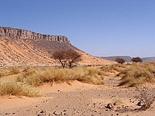
There is sparse grassland in some parts of the desert including the highlands and northern and southern parts of the desert.
The desert landforms of the Sahara are shaped by wind or by extremely rare rainfall and include sand dunes and dune fields or sand seas, stone plateaus, gravel plains, dry valleys, dry lakes and salt flats.Land formations change regularly.
Many of its sand dunes reach over 180 meters (590 feet) in height.
Several deeply dissected mountains and mountain ranges, many volcanic, rise from the desert.
Emi Koussi (huge extinct volcano), a peak in the Tibesti Mountains is 3,415 meters (11,204 feet) high and the highest point in the desert.
Snow may fall occasionally in some of the higher mountain ranges. On Feb. 18, 1979, low altitude areas of the Sahara desert recorded their first snowfall in living memory. Snow fell in spots in southern Algeria. It snowed in Algeria again in 2012.
Most of the rivers and streams in the Sahara desert are seasonal or intermittent, the main exception being the Nile River, which crosses the desert from its origins in central Africa to empty into the Mediterranean.
There are some 20 or more lakes in the Sahara.Most of these are saltwater lakes. Lake Chad is the only freshwater lake in the desert.
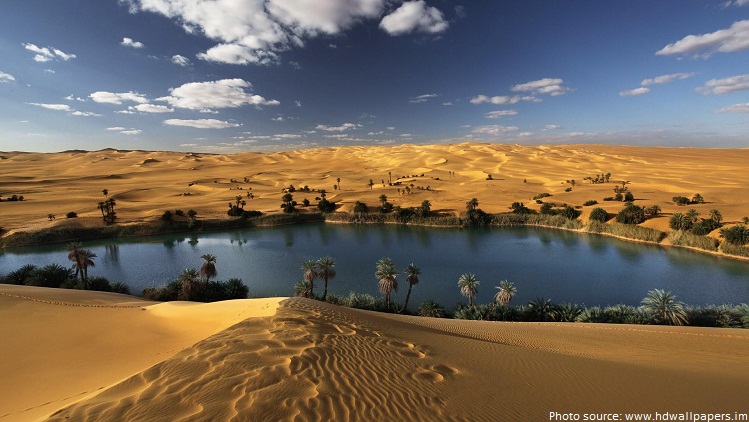
Some of the world’s largest supplies of underground water exist beneath the Sahara Desert, supporting about 90 major oases there.
Around two million people live in the Sahara Desert.
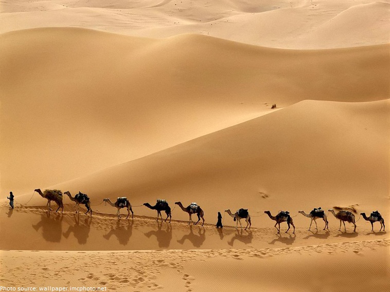
The people who live in the Sahara are mostly nomads. Nomads move from place to place.
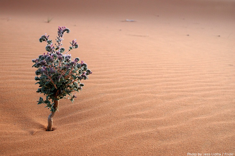
Like all deserts, the Sahara harbors a relatively sparse community of wild plants, with the highest concentrations occurring along the northern and southern margins and near the oases and drainages.
It has imposed adaptations on the plants.
For instance, near wadis and oases, plants such as date palms, tamarisks and acacia put down long roots to reach life-sustaining water.
In the more arid areas, the seeds of flowering plants sprout quickly after a rain, putting down shallow roots, and completing their growing cycle and producing seeds in a matter of days, before the soil dries out. The new seeds may lie dormant in the dry soil for years, awaiting the next rainfall to repeat the cycle.
From the Mediterranean vegetation which covered the Sahara mountains before they became a desert, only laurel and cypress trees remain in the region near gueltas.
Across the central, most arid part of the Sahara, the plant community comprises perhaps 500 species, which is extremely low considering the huge extent of the area.
Date palm trees, introduced by Arabs, is requisite for the existence of humans in the oasis; dates are very energetic food, trunks are used to make beams, leaves are used to make baskets, ropes, mats and covers for huts,… its preserves fruit trees against the sun.
Camels are the main animal of the desert. They have a great capacity to resist heat and thirst. Even above 50 C° (122 F°), they can stay without drinking water for many days. The camel is the favourite animal used by nomads. The second favorite animal for nomads in the Sahara desert is goat.
Several species of fox live in the Sahara, including the fennec fox, pale fox and Rüppell’s fox.
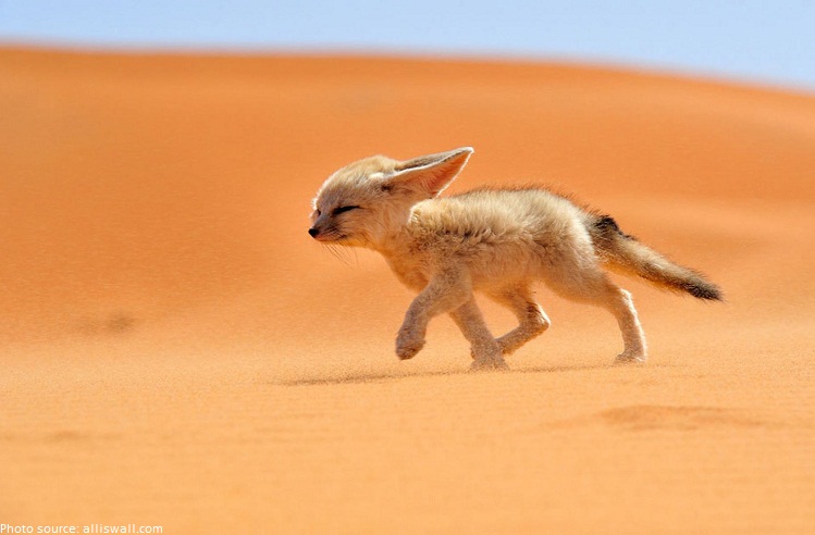
The addax, a large white antelope, can go nearly a year in the desert without drinking. The dorcas gazelle is a north African gazelle that can also go for a long time without water. Other notable gazelles include the rhim gazelle and dama gazelle.
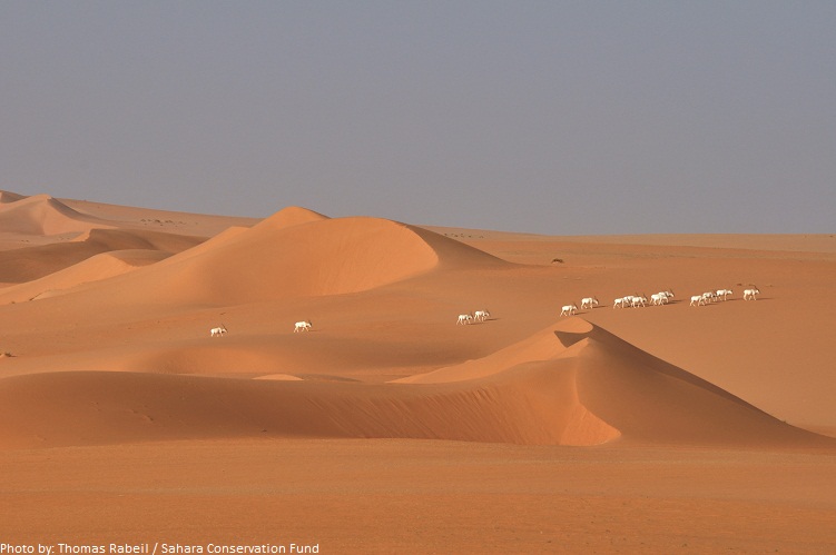
The northwest African cheetah, also known as the Saharan cheetah, is a subspecies of cheetah found in the northwestern part of Africa (particularly the central western Sahara desert and the Sahel).
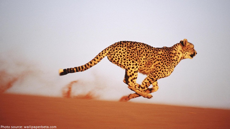
Other animals include the monitor lizards, deathstalker scorpions, sand vipers, hyrax and small populations of African wild dog, red-necked ostrich, secretary birds, Nubian bustards, various raptors…
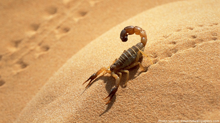
There is also dung beetle which was a holy symbol to the ancient Egyptians and has some impressive adaptability.
Saharan rock art is a significant area of archaeological study focusing on the precious treasures carved or painted on the natural rocks found in the central Sahara desert. There are over three thousand sites discovered that have information about Saharan rock art.
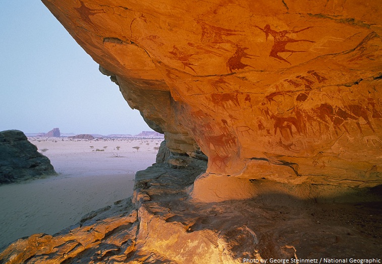
There have been dinosaur fossils found in the Sahara Desert.
Daytime temperatures can reach 58°C (136°F), but freezing temperatures are not uncommon at night. Its temperature can become as low as -6°C (22°F).
Half of the Sahara receives less than 2 centimeters (0.79 inches) of rain per year, and the rest receives up to 10 centimeters (3.9 inches) per year.The rainfall happens very rarely, but when it does it is usually torrential when it occurs after long dry periods, which can last for years.
Sandstorms are very common in the desert.Brown clouds of sand cover the sky as wind blows sand everywhere.
The word “Sahara” means “desert” in the Arabic language.
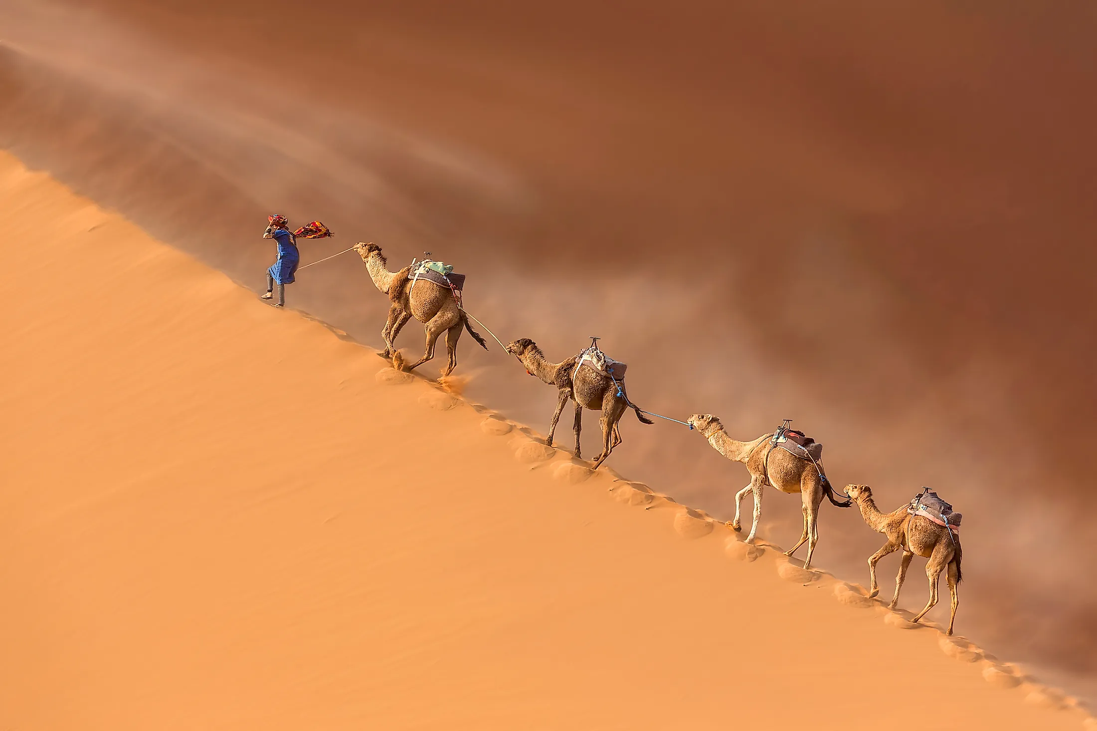
Covering a massive area of 9,200,000 sq. km, the Sahara Desert is considered the world’s largest hot desert and the third most extensive desert after the polar deserts of Antarctica and the northern Arctic. The Sahara Desert encompasses a major portion of North Africa, occupying about 31% of the entire African continent.

The Sahara Desert covers vast parts of 11 North African nations including Algeria, Egypt, Mali, Morocco, Western Sahara, Tunisia, Chad, Libya, Mauritania, Niger, and Sudan within its boundaries. The name of the Sahara Desert has been derived from the Arabic word ‘sahra’ which means ‘desert.’
Geography
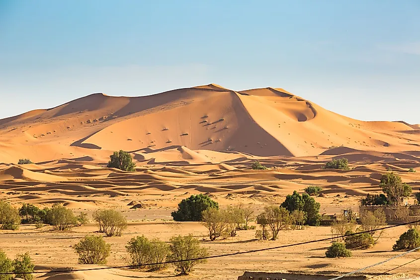
The expansive Sahara Desert has a length of approximately 4,800km and a maximum width of 1,800km. The desert is bounded by the Mediterranean Sea and the Atlas Mountains on the northern side; the Red Sea on the eastern side; the Atlantic Ocean on the western side and the semiarid Sahel region on the southern side. The Sahel region serves as a transition zone between the hot desert in the north and the humid savannas of Sub-Saharan Africa in the south.
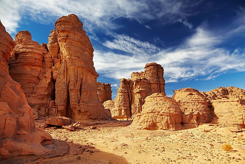
The Sahara Desert includes several topographical features such as hard rocky plateaus, rough mountains, extensive plains covered with sand and gravel, salt flats, sand seas, sand sheets, dry valleys, seasonally filled basins, dry lakes, high dunes, and huge oasis depressions. The dunes in the Sahara Desert reach a height of 183m and cover about 15% of the entire desert area. In addition to this, there are many volcanic massifs in the Sahara Desert including Aïr Mountains, Saharan Atlas, Adrar des Iforas, Ahaggar Mountains, Red Sea Hills, and the Tibesti Mountains. Situated at the extreme southeastern end of the Tibesti Mountains in the northern part of Chad is a shield volcano named Emi Koussi, which rises to an elevation of 3,415m and is the highest point in the Sahara Desert. Located in Egypt, the Qattara Depression is the lowest point in the Sahara Desert, which reaches 133m below sea level.
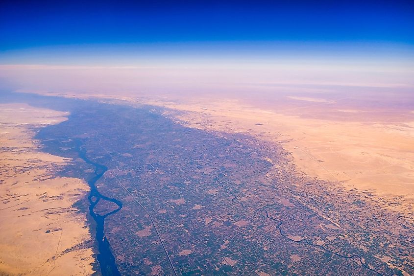
Although water sources are quite rare throughout the entire desert region, there are 2 large rivers and about 20 seasonal lakes and aquifers in the Sahara Desert. The large Nile and Niger rivers along with the seasonal lakes and aquifers provide the main source of water for the major desert oases. The Sahara Desert is further subdivided into many smaller deserts such as the Nubian desert, Tanezrouft desert, Sinai desert, Libyan desert, Tenere desert, etc. Some of the significant African cities that are situated in the Sahara Desert include El Oued in Algeria, Cairo in Egypt, Timbuktu in Mali, Faya-Largeau in Chad, Ghat in Libya, Nouakchott in Mauritania, and Agadez in Niger.
Climate
According to the Köppen climate classification, the vast Sahara Desert experiences a hot desert climate. The sky above the desert region usually remains quite clear and therefore the permanent absence of clouds allows for the unhindered high duration of sunshine over the entire desert area. The high sunshine exposure together with the lack of vegetation and extremely low precipitation makes the Sahara Desert one of the world’s hottest regions. During the hottest months, the average high temperature ranges between 38° to 40°C. The highest temperature in the Sahara Desert was recorded to be around 58°C in Aziziyah, Libya. The nighttime temperature ranges between 13° to 20°C. During winter, temperatures drop below the freezing point at nighttime. The Sahara Desert receives extremely low precipitation with the rainfall being very unreliable and extremely erratic. The annual evaporation rates are relatively much higher ranging from 2,500mm to over 6,000mm in the entire Sahara Desert region.
Ecology
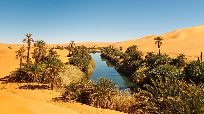
The Sahara Desert contains many ecological regions or ecoregions. These are as follows: The Atlantic Coastal Desert ecoregion covers an area of 39,900 sq. km along the Atlantic coast in the western part of the Sahara Desert. The North Saharan steppe and woodlands ecoregion cover an area of 1,675,300 sq. km along the northern part of the Sahara Desert. The Sahara Desert ecoregion covers an area of 4,639,900 sq. km in the central part of the Sahara Desert. The South Saharan steppe and woodlands ecoregion covers an area of 1,101,700 sq. km and runs from the east to the west direction between the hot Sahara Desert and the humid Sahel savannas. The West Saharan Montane Xeric Woodlands ecoregion covers an area of about 258,100 sq. km and encompasses many volcanic highland areas in the Sahara Desert. The Tibesti-Jebel Uweinat montane xeric woodlands ecoregion covers an area of about 54,000 sq. km in the eastern parts of the Sahara Desert.
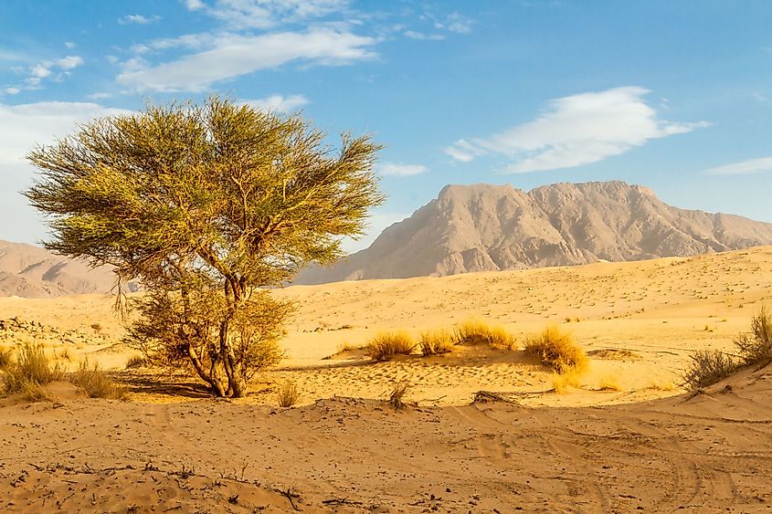
As mentioned above, the Sahara Desert experiences extremely harsh climatic conditions, and therefore the desert supports only those plants and animals that can survive in its extremely dry and hot climate. It has been recorded that there are about 2,800 vascular plant species in the Sahara Desert, among which one-quarter of these plants are endemic to the region. More than 500 species of plants are found in the central Sahara area. Some of these significant plants include acacia trees, succulents, Saharan cypress, grasses, Laperrine’s olive tree, date palms, tamarisk, spiny shrubs, desert thyme, etc. These plants have adapted to the arid conditions in the Sahara Desert by growing shorter to avoid the loss of water through the strong winds. Moreover, these plants store water in their thick stems that they can utilize during the dry periods and have also developed long roots that can horizontally travel in search of surface moisture. The plants also have small thick leaves to avoid loss of water through evapotranspiration.
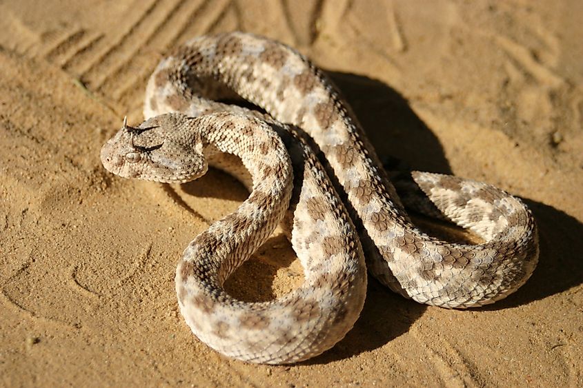
It has been recorded that about 100 reptilian species, 90 avian species, 70 mammalian species, and a wide array of different animal species are found in the Sahara Desert. Some of the major animals that are found in the Sahara Desert include desert foxes, addax antelopes, gazelles, Saharan cheetah, African wild dog, hyrax, deathstalker scorpion, Saharan silver ant, Dromedary camels and goats, sand vipers, monitor lizards, desert crocodiles, etc. Notable avian species like the red-necked ostrich, African silverbill, black-faced firefinch, etc. are also found in the Sahara Desert.
Brief History
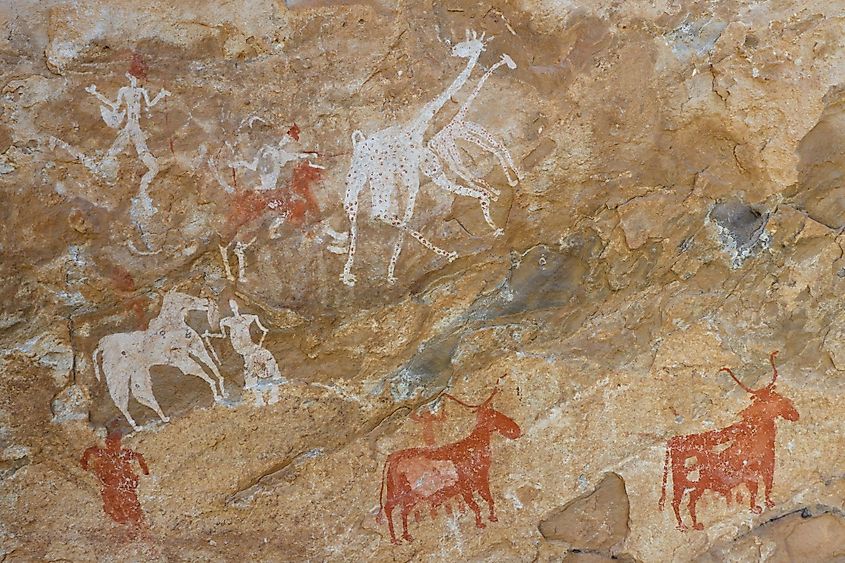
Several studies have revealed that since the end of the last glacial period, several people lived along the edge of the Sahara Desert. Archaeologists have discovered numerous petroglyphs in the central part of the Sahara Desert that dates back to several thousand years. The Kiffian civilization was one of the oldest civilizations in the Sahara Desert. After the Kiffians, the region was inhabited by people of several cultures including Tenerians, Tashwinat Mummy, Nubians, etc. Around 6,000 BCE, the Egyptians arrived in the Sahara region and started practicing agriculture and cattle herding. It is believed that during this time the Sahara region used to be lush green and supported a large number of plants and animals. But, approximately about 5,400 years ago, the gradual shift in the Earth’s axis, led to the increase in temperature, decrease in precipitation, and extension of desertification in the Sahara region. From 1200 to 800BCE, the area was occupied by Phoenicians and then in the later years by Greeks, Garamantes, Romans, Berbers, Byzantines, and Ottomans. In the 19th century, the Europeans began to colonize the Sahara region. After the Second World War ended, most of the Saharan states achieved their independence.
More in Landforms
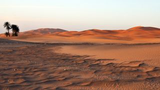
(Image credit: Ignacio Palacios/Getty Images)
The Sahara is the largest hot desert in the world and the third-largest desert overall, behind the cold deserts of Antarctica and the Arctic. The Sahara is one of the harshest environments on Earth, covering 3.6 million square miles (9.4 million square kilometers), an area about the size of the United States (including Alaska and Hawaii) and spanning nearly a third of the African continent. The name of the desert comes from the Arabic word ṣaḥrāʾ, which means «desert,» according to the Encyclopedia Britannica (opens in new tab).
What’s the geography of the Sahara?
The Sahara is bordered by the Atlantic Ocean to the west, the Red Sea to the east, the Mediterranean Sea to the north and the Sahel savanna to the south. The enormous desert spans 10 countries (Algeria, Chad, Egypt, Libya, Mali, Mauritania, Morocco, Niger, Sudan and Tunisia) as well as the territory of Western Sahara, a former Spanish colony that was annexed by Morocco in 1975, though control of the region is disputed by the Indigenous Saharawi people, the BBC reported (opens in new tab) in 2021.
The Sahara desert has a variety of land features, but it is most famous for the sand dune fields that are often depicted in movies. The dunes can reach almost 600 feet (183 meters) high, and they cover about 25% of the entire desert, according to the Encyclopedia Britannica. Other topographical features include mountains, plateaus, sand- and gravel-covered plains, salt flats, basins and depressions. Emi Koussi, an extinct volcano in Chad, is the highest point in the Sahara, reaching 11,204 feet (3,415 m) above sea level, and the Qattara Depression in northwestern Egypt is the Sahara’s deepest point, at 436 feet (133 m) below sea level.
Although water is scarce across the entire region, the Sahara contains two permanent rivers (the Nile and the Niger), as well as at least 20 seasonal lakes and huge aquifers, which are the primary sources of water for more than 90 major oases in the desert. Water management authorities once thought that the aquifers in the Sahara were «fossil aquifers» — water reserves that accumulated under different climate and geological conditions in the distant past — and feared that these resources would soon dry up due to overuse. However, a study published in the journal Geophysical Research Letters (opens in new tab) in 2013 discovered that the aquifers were still being fed via rain and runoff.
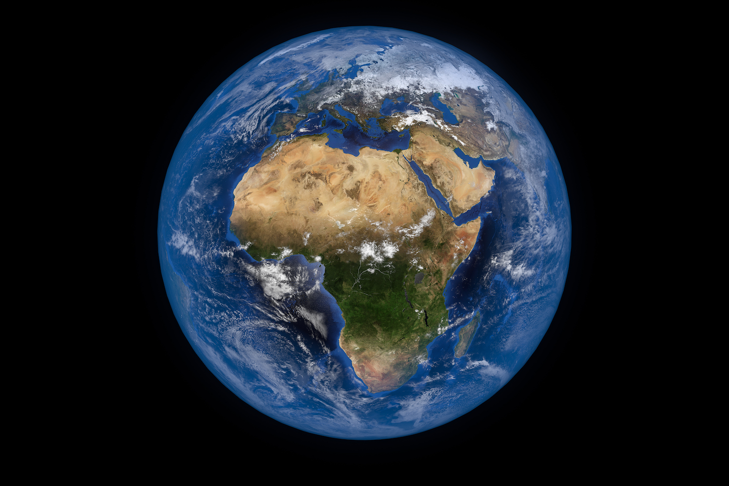
(opens in new tab)
What kinds of plants and animals live here?
Despite the harsh, arid conditions of the Sahara, many plant and animal species call the region home. Approximately 500 plant species, 70 mammalian species, 90 avian species, 100 reptilian species and numerous species of spiders, scorpions and other small arthropods live in the Sahara, according to the World Wildlife Fund (opens in new tab).
The camel is one of the most iconic animals of the Sahara, though its ancestors originated in North America. The ancestors of modern camels first appeared about 45 million years ago, and the large mammals eventually made their way to the African continent by traveling across the Bering isthmus between 3 million and 5 million years ago, according to a study published in 2015 in the Research Journal of Agriculture and Environmental Management (opens in new tab). Camels were domesticated about 3,000 years ago on the southeast Arabian Peninsula, to be used for transportation in the desert, according to the University of Veterinary Medicine Vienna (opens in new tab).
Camels, also known as the «ships of the desert,» are well adapted to the Sahara’s hot, arid environment, according to the San Diego Zoo (opens in new tab). The humps on a camel’s back store fat, which can be used for energy and hydration in between meals. Camels store energy so efficiently that they can go more than a week without water and several months without food.
Other mammal residents of the Sahara include gazelles, addaxes (a type of antelope), cheetahs, caracals, desert foxes and wild dogs. Many reptiles also thrive in the desert environment, including several species of snakes, lizards and even crocodiles in places where there is enough water. Several arthropod species also call the Sahara home, such as dung beetles, scarab beetles, «deathstalker» scorpions and many types of ants, according to the Sahara Conservation Fund (opens in new tab).
Plant species in the Sahara have adapted to the arid conditions, with roots that reach deep underground to find buried water sources and leaves that are shaped into spines that minimize moisture loss, according to the BBC (opens in new tab). The most arid parts of the desert are completely devoid of plant life, but oasis areas, such as the Nile Valley, support a large variety of plants, including olive trees, date palms and various shrubs and grasses.
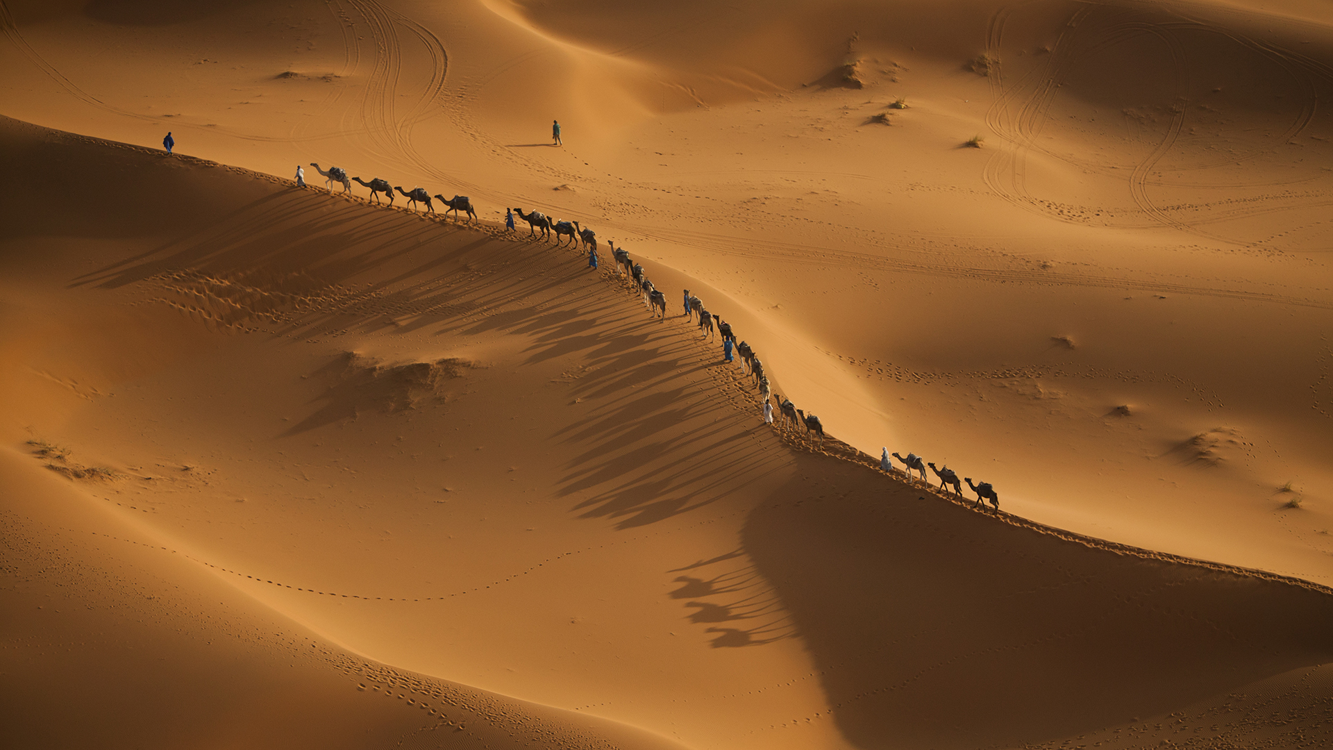
(opens in new tab)
What’s the climate like in the Sahara?
Today, the Sahara has a dry, inhospitable desert climate. However, it alternates between harsh desert and another extreme — a lush, green oasis — every 20,000 years, according to a study published in 2019 in the journal Science Advances (opens in new tab). The study’s authors examined marine sediments containing dust deposits from the Sahara from the past 240,000 years. They found that the cycle between a dry and a green Sahara corresponded to the slight changes in the tilt of Earth’s axis, which also drives monsoon activity. When Earth’s axis tilted the Northern Hemisphere just a single degree closer to the sun (about 24.5 degrees instead of today’s 23.5 degrees), it received more sunlight, which increased the monsoon rains and, therefore, supported a lush, green landscape in the Sahara.
Archaeologists have discovered prehistoric cave and rock paintings and other archaeological remains that shed light on what life was like in the once-green Sahara. Bits of pottery suggest that about 7,000 years ago, herders raised livestock and harvested plants in what now is an arid desert.
But for the past 2,000 years or so, the climate of the Sahara has been fairly stable — and dry. The northeastern winds strip moisture from the air over the desert and drive hot winds toward the equator. These winds can reach exceptional speeds and cause severe dust storms that can drop local visibility to zero. Dust from the Sahara travels on trade winds all the way to the opposite side of the globe.
Precipitation in the Sahara ranges from zero to about 3 inches (7.6 centimeters) of rain per year, researchers reported in 2014 in the journal American Meteorological Society (opens in new tab). Occasionally, snow falls at higher elevations. Year-round, temperatures in dry, arid deserts such as the Sahara are about 60 to 77 degrees Fahrenheit (20 to 25 degrees Celsius) on average, soaring as high as 120 F (49 C) in the summer during the daytime and plummeting to 0 F (minus 18 C) during the winter at night, according to the University of California Museum of Paleontology Berkeley (opens in new tab) (UCMP).
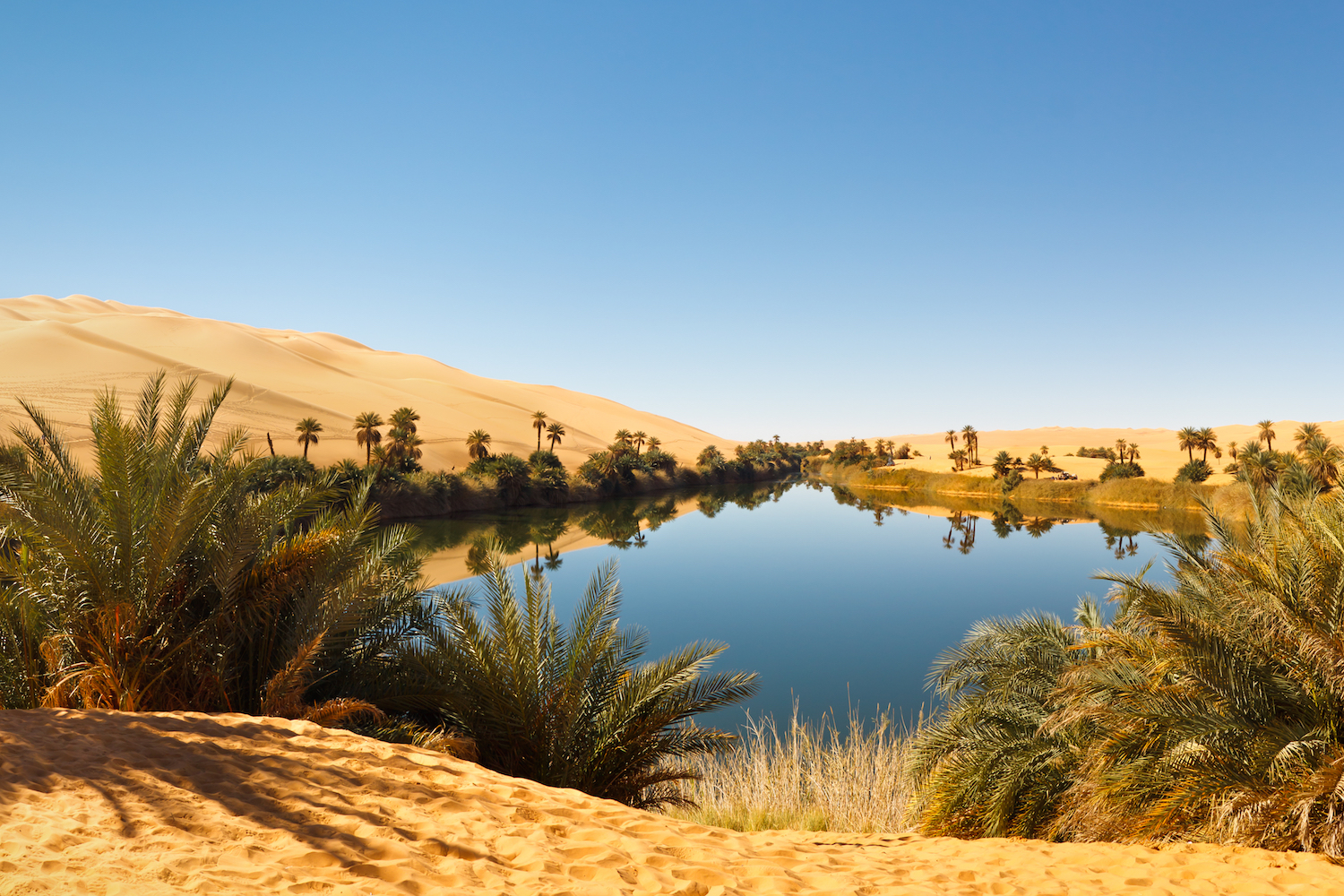
(opens in new tab)
Is climate change affecting the Sahara?
The area of the Sahara desert has grown nearly 10% since 1920, according to a 2018 study published in the Journal of Climate (opens in new tab), and the desert will likely continue to expand at a comparable rate until 2050, according to another study, published in 2020 in the journal Scientific Reports (opens in new tab). Although all deserts, including the Sahara, increase in area during the dry season and decrease during the wet season, human-caused climate change, in conjunction with natural climate cycles, is causing the Sahara desert to grow more and shrink less over time. The 2018 study’s authors estimated that approximately a third of the desert’s expansion was due to human-driven climate change.
One proposal for mitigating the effects of climate change is to install large-scale wind and solar farms in the Sahara. The farms would provide clean energy and reduce the amount of greenhouse gases entering the atmosphere, and may also promote increased precipitation in the vicinity, according to a 2018 study published in the journal Science (opens in new tab). Simulations showed that precipitation over wind farms would double, on average, thereby increasing vegetation by an estimated 20%. The solar farm simulations produced similar results.
Additional resources
Discover what the Sahara was like millions of years ago, during the Cretaceous period, in this 2019 study in the journal Bulletin of the American Museum of Natural History (opens in new tab). Find out more about one of the desert’s most striking landscape features today, the Aïr Mountains in central Niger, in a case study from the U.S. Geological Survey (opens in new tab). Visit the Sahara with Sir David Attenborough, to learn about the extreme adaptations that enable animals to survive the desert’s harsh conditions, in an episode of the BBC One documentary, «Africa (opens in new tab).»
BIBLIOGRAPHY
Gonçalvès, J., et al. “Quantifying the Modern Recharge of the ‘Fossil’ Sahara Aquifers.” Geophysical Research Letters, vol. 40, no. 11, 2013, pp. 2673–2678., https://doi.org/10.1002/grl.50478 (opens in new tab).
“Northern Africa.” WWF, World Wildlife Fund, https://www.worldwildlife.org/ecoregions/pa1327 (opens in new tab).
Introduction to Camel Origin, History, Raising … (PDF) https://www.researchgate.net/publication/284898592_Introduction_to_Camel_origin_history_raising_characteristics_and_wool_hair_and_skin_A_Review (opens in new tab).
“Origin of Dromedary Domestication Discovered.” Vetmeduni, https://www.vetmeduni.ac.at/en/infoservice/presseinformation/presseinformationen-2016/origin-of-dromedary-domestication-discovered (opens in new tab).
“Camel.” San Diego Zoo Wildlife Alliance Animals and Plants, https://animals.sandiegozoo.org/animals/camel (opens in new tab).
“Wildlife Conservation Network (WCN).” Sahara Conservation Fund, 18 Sept. 2019, https://www.saharaconservation.org/Wildlife (opens in new tab).
Skonieczny, C., et al. “Monsoon-Driven Saharan Dust Variability over the Past 240,000 Years.” Science Advances, vol. 5, no. 1, 2019, https://doi.org/10.1126/sciadv.aav1887 (opens in new tab).
Twentieth-Century Climate Change over Africa … — UMD. https://www2.atmos.umd.edu/~nigam/JCLIM.African.Sahara.Desert.Expansion.published.29March2018.pdf (opens in new tab).
Liu, Y., Xue, Y. Expansion of the Sahara Desert and shrinking of frozen land of the Arctic. Sci Rep 10, 4109 (2020). https://doi.org/10.1038/s41598-020-61085-0 (opens in new tab).
Li, Yan, et al. “Climate Model Shows Large-Scale Wind and Solar Farms in the Sahara Increase Rain and Vegetation.” Science, vol. 361, no. 6406, 2018, pp. 1019–1022., https://doi.org/10.1126/science.aar5629 (opens in new tab).
O’leary, Maureen A., et al. “Stratigraphy and Paleobiology of the Upper Cretaceous-Lower Paleogene Sediments from the Trans-Saharan Seaway in Mali.” BioOne Complete, American Museum of Natural History, https://bioone.org/journals/bulletin-of-the-american-museum-of-natural-history/volume-2019/issue-436/0003-0090.436.1.1/Stratigraphy-and-Paleobiology-of-the-Upper-Cretaceous-Lower-Paleogene-Sediments/10.1206/0003-0090.436.1.1.short (opens in new tab).
“West Africa: Land Use and Land Cover Dynamics.” Landscapes of the Sahara Desert | West Africa, https://eros.usgs.gov/westafrica/case-study/landscapes-sahara-desert (opens in new tab).
“Africa, Sahara.” BBC One, BBC, 31 Aug. 2019, https://www.bbc.co.uk/programmes/b01qh31v (opens in new tab).
This article was updated on Feb. 24, 2022, by Live Science Senior Writer Mindy Weisberger.
Rachel Ross is a science writer and editor focusing on astronomy, Earth science, physical science and math. She holds a Bachelor of Arts in Philosophy from the University of California Davis and a Master’s degree in astronomy from James Cook University. She also has a certificate in science writing from Stanford University. Prior to becoming a science writer, Rachel worked at the Las Cumbres Observatory in California, where she specialized in education and outreach, supplemented with science research and telescope operations. While studying for her undergraduate degree, Rachel also taught an introduction to astronomy lab and worked with a research astronomer.
Most Popular
Discovering the Types of the Largest Deserts in the World
Before we get started, let’s get you acquainted with the four main types of deserts. Gaining information about them helps you know the difference between the large hot and cold landscapes. However, the main thing you need to know about deserts lies in their climates. We mentioned how global warming affects these wastelands but they don’t get much precipitation. Because of this, most people believe that all deserts feature only sandy views. Not a lot of people know that some deserts grow vegetation for the animals that live there. Unfortunately, the common answer to “Name the largest desert in the world” is usually the Sahara Desert. That response would’ve been correct if the question was “What is the largest subtropical desert in the world?” To avoid any future confusion, we decided to explain how you can differentiate the four main types of deserts.
Cold Deserts
First, the largest desert in the world belongs to the Polar Deserts category. These areas reach their warmest temperatures at less than 10 degrees Celsius. Yes, we consider that measurement as freezing but that’s the warmest record in those areas. Plus, they only receive yearly precipitation of about 250 millimeters. Due to global warming, polar deserts now contain lesser gravel plains and bedrock compared to the Ice Age. Nowadays, you may hear of melting ice caps along the Arctic. These instances caused a lot of panic for experts because it shows the severe effects of global warming.
You can find several cold winter deserts across the globe. Experts also dub these landscapes as semi-arid deserts due to the seasons of the area. Those who live nearby usually experience long and dry summers or cold winters with low rain and snowfall. The absence of higher rainfall comes from the area’s rain shadow effect. It occurs when a high mountain range keeps the sky’s moisture from reaching the area below. For example, the Gobi Desert experiences the rain shadow effect due to the Himalayan Mountains.
Hot Deserts
It may be surprising to most people but Coastal Deserts do exist. The disbelief usually comes from the fact that these majestic landscapes feature views of oceans or seas. There aren’t that many wastelands that belong to this major category. You may spot the largest coastal deserts located in Africa and South America. These areas experience an easterly pattern of winds that cause the prevention of moisture on the land. However, they still receive about 13 centimeters of rainfall every year.
Experts dub the hottest wastelands as Subtropical Deserts. You may find his type of barren landscape in almost every continent in the world. These areas experience intense hot and dry summers. During winter, these deserts feature cool yet dry temperatures. Despite receiving annual rainfalls, it only happens in short bursts. This causes the land or soil of subtropical deserts to be sandier or rockier.
The Largest Desert in the World: Antarctic Desert (Polar)
When talking about the largest desert in the world, the discussion must revolve around Antarctica. Unbeknownst to many, the Antarctic Desert spans the whole continent’s landmass. Everything seen with the naked eye is covered with snow and ice. The area only experiences the summer and winter seasons. When we say summer, it just means that the continent faces the sun. The way we experience day and night can only be measured by hours when in Antarctica. No matter what you try, the only way to tell if a day passed lies on your watch. The sun won’t set unless winter arrives. By then, the icy landscape remains enveloped in darkness until summer returns. Because of this, the Antarctic Desert’s soil cannot grow any type of vegetation. Moss and algae hail as the only types of plants that manage to survive in the ruthless Antarctic weather.
Despite its freezing temperatures, tourists flock to the Antarctic Desert during the summer. However, only animals permanently reside in the continent. We humans can’t live there unlike the penguins and seals that are used to the cold temperature. Even scientists who study and monitor Antarctica’s ice follow a rotation to avoid staying there for too long. When traveling around the continent, most people avoid the middle area. Compared to the coastal area, Antarctica’s midpoint offers intense cold signatures that may freeze people to death.
Arctic Desert (Polar)
Unlike the Antarctic, the temperatures measured at the second largest desert in the world let people reside there. Some vegetation grows thanks to the area’s tundra. The land experiences a climate of long winters and short summers. Since the desert covers the Arctic Ocean and the North Pole, the icy landscape receives sunlight almost every day during the summer. Once winter comes, the residents need to adjust to days with complete darkness.
People consider the Arctic Desert as a terrestrial ecoregion. It spans about 62,300 square miles. From west to east, it measures 2,000 kilometers from west to east and 1,000 kilometers from north to south. Russian island groups Franz Josef Land, Severny Island, and Severnaya Zemlya belong to the Arctic Desert. It also covers the island of Svalbard in Norway. Because of this, Norwegians and Russians can choose to live in the residential areas of these island groups. However, they must prepare for the mentioned harsh climate. Additionally, those interested in becoming residents must secure their funds for the area’s costly living expenses. Due to the expensive conditions, establishments and companies limited the job opportunities for hopeful individuals. We suggest you just take a trip to the area if you want to check out the beautiful Arctic Desert view.
Sahara Desert (Subtropical)
The Sahara Desert hails as the most famous largest desert in the world on our list. Its name comes from the Arabic word “ṣaḥrā” which means desert. In short, the Sahara Desert features the redundant name “desert desert.” It also goes by the titles “Largest Hot Desert” or “Largest Subtropical Landscape.” Located in North Africa, the sandy landscape stretches out to 11 countries. When you search for pictures of it on Google, the first choices you see usually include its sand dunes fields. This beautiful pattern of sand makes up about 15% of the desert’s area. They also reach up to 600 feet or 183 meters high. Meanwhile, Mt. Koussi, an extinct volcano, hails as the highest point in the hot landscape. It stands out with a height of about 11,204 feet or 3,415 meters.
The third-largest desert in the world is filled with not just sand but also a rich history. In 2012, archaeologists found cave and rock paintings that they can date back up to 7,000 years ago. The prehistoric artwork and remains showcase how people benefited from the lush greenery of the old Sahara. Since 1920, the Sahara Desert’s area grew about 10% of its original size. Some argue that the growth happens every dry season and returns to normal during the rainy season. However, a 2018 study states that climate change caused the expansion.
Arabian Desert (Subtropical)
Currently, the Arabian Desert holds the title of the fourth largest desert in the world. Despite being dubbed as a desert, the Arabian subtropical landscape features several types of flora and fauna. It covers about 900,000 square miles across the major areas of Asia and the Arabian Peninsula. For thousands of years, the Arabian Desert serves as a home to several explorers and nomad groups.
The ecoregion of the Arabian Desert covers famous sand deserts like Rub’ al-Khali, An-Nafud, and Ad-Dahna. the view of Rub’ al-Khali may seem familiar to you if you’re a movie buff or a gamer. Located in Abu Dhabi, the large and sandy landscape served as the Jakki in “Star Wars: The Force Awakens” in 2015. In the “Matrix” film series, that section of the Arabian Desert played as the base of Machine City, Zero-One. For games, it provided the desert settings for games like 80 Days, Uncharted 3: Drake’s Deception, and Torchlight II. Mentioning these titles may encourage you to book a trip to the fourth largest desert in the world. However, you better prepare for the area’s hyper-arid climate. As a desert, it barely gets enough precipitation to grow lush vegetation. In summer, the daily temperature reaches up to 51 °C or 124 °F.
Gobi Desert (Cold Winter)
Spanning across major parts of Mongolia and China, the Gobi Desert hails as the largest desert in East Asia. Its cold terrain spans about 500,000 square miles. If you plan to travel here, you must equip your body with enough protection from the harsh cold weather. The nomad groups who reside in the Gobi Desert do not stay in one area due to the area’s climate. Because of this, we suggest you visit the beautiful landscape during the summer.
You might see historical accounts about the Gobi Desert written by Marco Polo himself. As one of the largest deserts in the world, the large expanse of land also offers a long history. Merchants once crossed its vast landscape to travel on the ancient Silk Road from East to West. Its rich history also includes holding forgotten parts of the Great Wall of China. These facts usually entice history buffs to travel and see the Gobi Desert’s beauty and culture. One of the most mesmerizing sights to behold is the Dunhuang Crescent Moon Spring. You can find it the unique oasis at the foot of the Singing Sand (Mingsha) Mountain. Most tour packages offered in the Gobi Desert include witnessing the spring in real life. Locals usually dubbed such tours usually include the Silk Road’s long history to entice more visitors.
Patagonian Desert (Cold Winter)
Another largest desert in the world that belongs to the Cold Winter category is the Patagonian Desert or Patagonian Steppe. It spans the countries of Chile, Argentina, and the Falkland Islands of the United Kingdom. The desert’s recorded temperature reaches 12°C (53.6°F) with a daily average of 3°C (37.4°F). When it comes to seasons, the area experiences about five months of summer and seven months of winter. Despite the harsh climate, several plants and animals manage to survive in the cold desert. The animals permanently reside in the Patagonian Desert where they can easily hunt for food or prey. One of the most common animals you can spot includes the South American Gray Fox or the Patagonian Fox. It preys on small mammals and rodents that also reside in the desert. Meanwhile, people who lived and traveled around the vast desert includes several indigenous groups. Experts further proved these facts when a few cave paintings emerged from certain areas.
The Patagonian Desert also played a big part in Argentian and European history during the mid-19th century. Several settlements from nearby regions spread throughout the desert’s edges. In the 1870s, the Argentine army set out to fulfill the Conquest of the Desert campaign. It aimed to take down warlords and claim sections of the landscape to Argentina. The conquest caused the tragic population decline of indigenous people in the area. However, the recorded death toll of about 1,000 natives. Those who survived fled and sought refuge in Chile and the Andes. This tragic incident in the Patagonian Desert serves as a dark reminder of the mistreatment of indigenous people. Some visit the area to honor and recall the peaceful lives they led in the desert.
Great Victoria Desert (Subtropical)
Among all the largest deserts in the world, the Great Victoria Desert in Australia hosts the most diverse species of reptiles. Experts recorded more than 100 species, including the famous Thorny Devil (Moloch horridus). As a subtropical desert, the Great Victoria Desert features a large wasteland with patches of grassland plans and small sandhills. Despite the area’s intense heat signatures, several groups of Indigenous Australians reside in the country’s largest desert. Their communities also managed to make a living and develop their culture thanks to various outreach programs.
The Great Victoria Desert got its name in 1875 from British explorer Ernest Giles. He thought of the name to honor then-reigning Queen Victoria. At that time, he was hailed as the first European to complete an expedition and cross the vast landscape. Following his achievement, other explorers such as David Lindsey and Len Beadell also held expeditions in the desert. Nowadays, several tourism Australian tourism groups can help you achieve the same feat. Locals divided different sections of the large desert for interested tourists. Starting from the desert’s western outskirts, the division proceeds to the Little and Big Deserts. They then usually end at the Murray Sunset National Parks for interested campers. Customers can choose between one or multiple-day tours with camping options. They may also select packages that include seeing the wildlife that resides in Australia’s largest desert.
Kalahari Desert (Subtropical)
Like most of the largest deserts in the world, the Kalahari Desert attracts tourists despite the area’s harsh climate. We know it as a subtropical desert that experiences extreme temperature changes throughout the day. The vast wasteland features areas with relatively high altitudes. No matter what season, daytime brings out intense heat in the area. Afterward, the absence of the sun makes the wasteland drop up to zero degrees at night, especially during winter. Despite this, the Kalahari Desert offers small areas of lush vegetation for its inhabitants. Located in South Africa, the majestic desert covers about 900,000 square kilometers of land. Between 1996 and 1997, more people heard about the desert’s secret treasures, namely, an unknown diamond mine. The tribes residing in the said area fought in court after they got evicted from their homes. Fortunately, the Botswana High Court ruled in the tribes’ favor.
The Kalahari Desert reaches the South African countries of Namibia, Botswana, and the Northern Cape Province. Despite the harshness of the semi-arid climate, several types of wildlife live peacefully in the vast desert. The landscape also hails as one of the oldest and largest deserts in the world. Because of this, tourists can’t help but travel to the Kalahari Desert. Most of them hope to learn about the area’s rich history. Other people book eventful safaris that feature the desert’s wildlife and culture.
Great Basin Desert (Cold Winter)
The Great Basin Desert claims the title of being the largest desert in the USA. Because of this, it’s understandable why it also holds a top spot as one of the largest deserts in the world. With a reach of about 190,000 square miles, the Great Basin Desert spans the US States of California, Idaho, Oregon, Nevada, and Utah. The Sierra Nevada Range and the Rocky Mountains border the landscape on the west and east respectively. While experiencing less precipitation, the vast expanse receives light snowfall during the winter. Based on its name, the Great Basin Deserts consists of hundreds of basins and valleys. It also got its title from the natural drainage system made possible by the area’s rain shadow effect.
Tourists can’t help but flock to the Great Basin Desert for the unique sights and activities offered in the area. Upon arrival, they usually visit the rich environment history featured in the area. People love to check out the trees that lived up for more than 4,000 years during a relaxing stroll. Others choose to pass through the Lehman Caves, a subterranean cave system featuring crystals, stalactites, stalagmites, and flowstones. At night, visitors can admire the stars at the Basin’s Certified IDA International Dark Sky Park (IDSP). Once the total darkness falls, you can see up to five planets in a sea of twinkling stars.
Syrian Desert (Subtropical)
Aside from the Sahara, one of the most familiar largest deserts in the world we know is the Syrian Desert. The subtropical region stretches the countries of Syria, Jordan, Iraq, and Saudi Arabia. During Ancient Times, the nomadic Bedouin tribes famously settled around the desert’s oases. Some of their remaining ancestors continue to uphold their culture and tradition while residing in the vast landscape. Due to its rich history, you can find Safaitic inscriptions or South Semitic scripts. Historians can trace these old scriptures’ origins between the first century BC and the fourth century AD.
When tourists book tours in the Syrian Desert, they usually aimed to see the ruins of ancient cities like Palmyra. The old Semitic city earned its wealth from taking part in famous trade caravans. Their people also gained fame for building colonies along the Silk Road and the Roman Empire. Some of Palmyra’s known historical structures used to tower over a corner in the Syrian Desert. Due to the passage of time, only ruins of those structured can be seen today. Tours in the Syrian Desert used to include viewing the ruins of Palmyra. In 2011, the Syrian Civil War caused the steep decline of the country’s tourism. Unfortunately, this all happened just when tourism reached an all-time high. Around 2017, Syria’s government launched the Syrian Desert campaign to go against the Islamic State of Iraq and the Levant (ISIL). This further contributed to the decrease of tourists in fear of their safety.
Other Famous Deserts in the World
As we continue to discuss the world’s largest deserts you probably wondered why people love to travel to these places. What do they find so alluring about barren wastelands? What makes the largest deserts of the world such hotspots for tourism? Well, we believe one of the main reasons came from the crowds of people on vacation. Unlike camping grounds in forests and national parks, camping near the desert offers fewer crowds. Plus, not a lot of people get enticed with adjusting to the extreme weather of these wastelands.
Aside from the largest deserts in the world, people also like to visit different wastelands that offer beautiful views. Those who wish to travel to more than one famous desert usually stay in North and South America. These continents feature several deserts with harsh climates that you can adjust to during the summer. Below, we compiled the information we gathered about two deserts that receive a lot of tourists in the summer.
Mojave Desert (Subtropical)
Americans dubbed the Mojave Desert as the driest desert in the USA. Despite being a small desert, it stretches between the US States of California, Nevada, Arizona, and Utah. Throughout the year, the Mojave Desert experiences extreme temperature readings. In the winter, the area suffers from strong winds and intense bouts of rain and snowfall. Meanwhile, strong thunderstorms that result in flash floods occur during the late months of summer. Despite this, people continue to flock to the vast expanse of the Mojave Desert. If you’re a movie buff, the wasteland might seem familiar to you. Its beautiful landscape was used for films like “Star Trek” and “Fear.”
Due to the increase of human development, a big chunk of the Mojave Desert now features urbanized areas. More highways and structures keep appearing to entice more people to the area. Unfortunately, this caused the strictness of the desert’s intact conservation status. The central and southwest parts remain open to urban development and agricultural grazing. However, areas like the Mojave National Preserve and Death Valley receive protection from the California Desert Protection Act.
Atacama Desert (Mild Coastal)
Another landscape beloved by tourists is the Atacama Desert. Its vast expanse reaches the countries of Chile and Peru. The area experiences such a lack of precipitation that it became one of the driest places in the world. Dubbed as the driest nonpolar desert, experts often compare the wasteland to that of Mars‘ atmosphere. Experts use the Atacama Desert as a testing site due to the similar Mars compounds in the area. They usually roll out rover prototypes that they plan to send to the Red Planet.
Despite its arid weather, tourists continue to visit the Atacama Desert for its picturesque views. The mild coastal desert displays a colorful sky both night and day. The desert plateau’s sky gets painted with purple, pink, and orange views when the sun sets or rises. At night, visitors flock the several observatories that feature mesmerizing views of the stars.
Sahara is the World’s largest and most extensive hot desert located in North Africa. The Arabic word ṣaḥrāʾmeans “desert.” It ranks as the third largest desert after the cold deserts Antarctica and the Arctic. The desert covers an area of 3.6 million square miles (9.4 million square kilometers), which is nearly one-third of the African continent, and about the size of the US, including Alaska and Hawaii.
Location of Sahara Desert and the Countries it Covers
The Red Sea surrounds the Sahara on the east, the Atlantic Ocean on the west, on the north the Mediterranean Sea and the Sahel, a semi-arid tropical savannah of Sudan and the Valley of River Niger of Sub Saharan Africa on the south.
This gigantic desert is spread out in 11 countries: Algeria, Chad, Egypt, Libya, Mali, Mauritania, Morocco, Niger, Western Sahara, Sudan, and Tunisia.
Sahara holds very versatile features of the land that has been shaped by wind over time such as mountains, sand-dunes (erg), plateaus, barren stone plateaus (hamada), sand seas called ergs, sand-and gravel-covered plains (reg), basins, salt flats, dry valleys (wadis) and depressions.
The mountain ranges, many of which are volcanic, get more rainfall and cooler temperature than the rest. The highest point in the Sahara is Mount Koussi, an extinct volcano in Chad at 11,204 feet (3,415 m), is a part of the Tibesti Range in northern Chad. The deepest point in the Sahara is the Qattara Depression in Egypt at 436 feet (133 m) below sea level.
However, the Sahara desert is most famous for the fields of the sand dune that you see in movies. The dunes cover only about 15 percent of the entire desert but can reach up to 600 feet (183 meters) high.
The water is scarce across the entire desert. However, there are two permanent rivers-the Nile (originates in central Africa, flows northward through Sudan and Egypt and empties northwards into the Mediterranean Sea) and the Niger (originates in Western Africa, flows through Mali, then desert and Nigeria and empties into the Gulf of Guinea), minimum 20 seasonal lakes and vast underground reservoirs or aquifers. These are the primary sources of water in the 90 and more major desert oases.
Once the water management authorities feared that the aquifers would dry up soon due to overuse, however, a study published in 2013 in the journal Geophysical Research Letters, found the rain and runoff were still feeding the “fossil” (non-renewable) aquifers.
Sahara desert is the World’s hottest large land area. Two climatic regimes dominate the Sahara desert: a dry northern subtropical climate and a dry southern tropical climate. The characteristics of dry subtropical climate are unusually high-temperature ranges, annual and diurnal, hot summers and cold to cool winters, and two precipitation maximums.
The dry tropical climate, on the other hand, has a strong yearly temperature cycle following the declination of the sun; dry, mild winters; and a hot, dry season before the variable summer rains.
The climate is scorching hot and parched dry. The average summer temperatures in the day time are often 100.4F and 104.0°F (above 38 degrees Celsius) except for areas with high altitudes. The highest temperature that is recorded in the Sahara desert is at 136°F (58°C) in Aziziyah, Libya.
The Algerian Desert with an elevation of 1,240 feet above sea level, Salah in Algeria, a part of Sahara Desert also records high temperatures. The temperature can drop to near-freezing temperatures making the nights freezing cold. Occasionally, snow falls at higher elevations.
The skies are always cloudless clear in the Sahara Desert, and the sunshine duration can reach as high as for about 3600 hours to 4,300 hours of bright sunshine yearly, which is about 82% to 98% of the time. The highest sunshine duration is recorded in parts of Upper Egypt and around the Nubian Desert.
Precipitation ranges from zero to about 3 inches of rain per year in the Sahara. The rainfall is deficient in the northern and southern fringes of the desert, to almost zero rainfall in the eastern and central regions of the desert. There are also some locations devoid of rain for several years. The continuous exposure to high sunshine and very low humidity result in the lack of vegetative cover and almost no rainfall.
The northern fringes of the Sahara receive winter clouds and minimal average annual rainfall between 4 inches and 10 inches as a result of the low-pressure systems flowing through the Mediterranean Sea along the polar front. Few areas found in this zone include Ouarzazate in Morocco and Biskra in Algeria.
The southern fringes of the desert bordering the Sahel, receive summer clouds and here minimal average annual rainfall ranges from 4 inches to 10 inches due to the arrival of the Intertropical Convergence Zone, ITCZ. The zone includes Agadez in Niger and Timbuktu in Mali.
Most of the central Sahara receives almost zero rain being unaffected by the southerly or the northerly atmospheric variance. It is under the constant influence of the anticyclonic weather patterns. In this zone, the average annual rainfall can drop to as low as 0.04 inches.
In 2019 a study published in the Journal Science Advances disclosed an amazing fact that the Sahara has alternate cycles of one dry, inhospitable desert and another lush, green oasis in about every 20,000 years. The marine sediments containing dust deposits from the Sahara over the past 240,000 years were examined by the authors of the study.
The team found that slight changes in the tilt of Earth’s axis cause the cycle between a dry and a green Sahara which also drives monsoon activity. When the axis of the Earth tilted just a single degree closer to the sun in the Northern Hemisphere that is about 24.5 degrees instead of 23.5 degrees now, it received more sunlight increasing the monsoon rains and therefore, supporting a lush green landscape in the Sahara.
The archaeological discovery of prehistoric cave and rock paintings and other archeological remains give an idea about life in the once-green Sahara. The bits of pottery suggest that ancient herders raised livestock and harvested plants about 7,000 years ago, which is now an arid desert.
The climate of the Sahara has been relatively stable for the last 2,000 years. The powerful and capricious winds from the northeast dry out the air over the desert and drive hot winds toward the equator. These winds cause severe dust storms due to their exceptional speeds, and local visibility becomes zero. Dust travels on trade winds all the way from the Sahara to the opposite side of the globe.
Climate Change Effects on Sahara
The Sahara desert has grown about 10% in size since 1920, according to a 2018 study published in the Journal of Climate. Usually, all deserts increase in the area during the dry season and decrease during the wet season, similar to what happened in Sahara. However, human-caused climate change intervenes with natural climate cycles and causes the Sahara to grow more and shrink less. Approximately one-third of the expansion in the desert was due to the human-made climate change as per the estimation of the study’s authors.
The best way for mitigating the effects of climate change is to install wind and solar farms in large-scale in the Sahara. The wind and solar farms would provide clean energy while reducing the amount of greenhouse gases entering the atmosphere. It may also help in increased precipitation in the vicinity according to the 2018 study published in the journal Science Advances.
The wind farm simulations showed that there would be warmer temperatures in areas with wind farms, due to the wind turbines, especially at night as they would bring warm air to the surface from higher in the atmosphere. As per the estimation of the researchers, the precipitation over the wind farms would double on average, which would increase vegetation by an estimated 20 percent. The solar farm simulations also generated similar results.
A large-scale wind farm in Sahara would produce approximately 3 terawatts of electrical power as predicted by the study authors, while a large Saharan solar farm would produce about 79 terawatts exceeding the electrical power of 18 terawatts that were consumed in 2017. The extra energy so produced could be utilized for more large-scale projects, including increased agriculture and water desalination.
Sources:
https://www.livescience.com/23140-sahara-desert.html
https://www.worldatlas.com/articles/what-is-the-temperature-in-the-sahara-desert.html
https://www.thoughtco.com/sahara-desert-overview-1435189
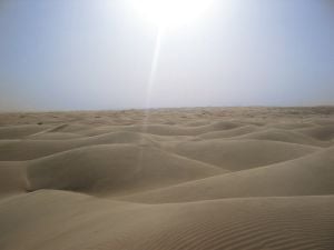
The sun shines over Saharan dunes
The Sahara, located in Northern Africa, is the world’s largest hot desert and second largest desert after Antarctica at over 3.5 million square miles (9 million square kilometers). Almost as large as the United States, it crosses the borders of 11 nations. While much of the desert is uninhabited, two million people are scattered across its vast expanses, not including those who live along the Nile and Niger riverbanks. The name Sahara is an English pronunciation of the Arabic word for desert.
Immediately after the last ice age, the Sahara was a much wetter place than it is today. Over 30,000 petroglyphs of river animals such as crocodiles exist, with half found in the Tassili n’Ajjer in southeast Algeria. Fossils of dinosaurs, including Afrovenator, Jobaria, and Ouranosaurus, have also been found here. The modern Sahara, though, is not as lush in vegetation, except in the Nile River Valley, at a few oases, and in the northern highlands, where Mediterranean plants such as cypresses and olive trees are found. The region has been this way since about 3000 B.C.E.
Geography
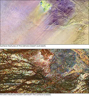
The top image shows the Safsaf Oasis on the surface of the Sahara. The bottom (using radar) is the rock layer underneath, revealing black channels cut by the meandering of an ancient river that once fed the oasis.
The boundaries of the Sahara are the Atlantic Ocean on the west, the Atlas Mountains and the Mediterranean Sea on the north, the Red Sea and Egypt on the east, and Sudan and the valley of the Niger River on the south.
The Sahara divides the continent into North and Sub-Saharan Africa. The southern border of the Sahara is marked by a band of semiarid savannas called the Sahel; south of the Sahel lies lusher Sudan and the Congo River Basin. Most of the Sahara consists of rocky hammada; ergs (large sand dunes) form only a minor part.
The highest part of the desert is at the summit of the volcano Mount Koussi in the Tibesti Mountains, which is 11,204 feet (3,415 meters) high. The lowest point of the Sahara is 436 feet (133 meters) below sea level in the Qattara Depression in Egypt.
Flora and fauna
Considering the hyper-arid conditions, the fauna of the central Sahara is richer than is generally believed. Within this ecoregion there are 70 species of mammals, 20 of which are large mammals. There are also 90 species of resident birds, and around one hundred species of reptiles. Arthropods are also numerous, especially ants. The animals include antelope, gazelles, jackals, hyenas, fennec foxes, rodents, small reptiles, insects, and scorpions. The mountains provide a home for the Barbary sheep, leopards, the addax, and the sand gazelle. The latter has splayed hooves that make it easier to travel in the sand. The fennec fox has large ears to dissipate heat and hairy soles to protect its feet while crossing the desert in search of lizards and locusts. These kinds of adaptations have allowed them to survive in such an inhospitable environment. Many of the animals get their water only through metabolic processes. Animals may lose 30-60 percent of their body mass and still recover.
The central Sahara is estimated to include only five hundred species of plants, which is extremely low considering the huge extent of the area. Plants such as acacia trees, palms, succulents, spiny shrubs, and grasses have adapted to the arid conditions, either by reducing water loss or storing water. Plant leaves may dry out totally and then recover.
Human activities are more likely to affect the habitat in areas of permanent water (oases) or where water comes close to the surface. Here, the local pressure on natural resources can be intense. The remaining populations of large mammals have been greatly reduced by hunting for food and recreation.
In recent years development projects have started in the deserts of Algeria and Tunisia using irrigated water pumped from underground aquifers. These schemes often lead to soil degradation and salinization.
Regions
Although the Sahara stretches across the entire continent, it can be subdivided into distinctive regions, including.
- Western Sahara: a series of vast plateaus in Morocco that extend to the foothills of the Atlas Mountains. There is no surface water but dry riverbeds (wadis) that only hold water during rare rainfall. Where the underground rivers that flow from the mountains emerge on the surface, they create small oases. The area contains such minerals as phosphates, iron, zinc, and gold.
- Great Western Erg and Great Eastern Erg: An immense, uninhabited area in Algeria consisting mostly of sand dunes shaped by the wind into peaks and hollows; the two regions are separated by a rocky plateau. Precipitation is extremely low.
- Tanezrouft Desert: A rock desert in south central Algeria bisected by deep canyons and known as the «land of terror» because of its lack of water.
- Tassili N’Ajjer Desert: An extremely arid mountainous area in southern Algeria that once held lakes fed by mountain streams. Wind erosion has created numerous rock formations. Ancient cypresses and wild olive trees grow at the higher altitudes. Cave paintings and Neolithic artifacts dating back six to seven thousand years ago have been found. Today, Tuaregs grow crops around the wadis and oases.
- Hoggar Desert: A mountainous, largely uninhabited part of Algeria characterized by igneous and volcanic rock formations. The mountains contain caves with ancient paintings depicting cattle, rhinoceros, elephants, giraffes, and jackals.
- Libyan Sahara: Rock plateaus and sandy plains extend from eastern Libya to northwestern Sudan. A group of oases enables the cultivation of cereals, olives, grapes, and dates.
- Fezzan Desert: An immense area of alternating sandstone and limestone that form caves and natural arches in southwestern Libya. This region is known for its fossils and Neolithic artifacts and rock drawings of animals.
- Western and Eastern Egyptian Deserts: The Western Desert covers two-thirds of Egypt’s land area and merges into the Libyan Desert. Where there are depressions lower than sea level, several large oases exist, the largest of which is Siwa, which is surrounded by olive plantations. The Eastern Desert spreads between the Suez Canal and the Red Sea. Nomads raise herds of sheep, camels, and goats.
- Tibesti Mountains: Formed during a period of volcanic eruptions about seventy million years ago, the area now in Chad has numerous prehistoric rock carvings. The Australopithecus hominid known as «Abel» was discovered here.
- Ténéré Desert: The last southern offshoot of the Sahara, it is an area in Niger of undulating dunes, the most famous of which is the Erg of Bilma. Though now free of vegetation, except for a few oases that once formed the backbone of a caravan track, the desert has rock drawings of animals and fossilized tree trunks that point to wetter times in the ancient past.
- Aïr Massif: A rocky granite massif in central Niger, its flanks are chiseled by canyons long ago formed by rushing streams that are now dry most of the year. Agriculture takes place around the larger oases. Agadez, on the mountain’s southern slopes, is the largest population center in the area.
Climate
Did you know?
The climate of the Sahara has undergone enormous variation between wet and dry over the last few hundred thousand years
History
The climate of the Sahara has undergone enormous variation between wet and dry over the last few hundred thousand years. During the last ice age, the Sahara was larger than it is today, extending south beyond its current boundaries.[1] The end of the ice age brought wetter times to the Sahara, from about 8000 B.C.E. to 6000 B.C.E., perhaps due to low pressure areas over the collapsing ice sheets to the north.[2]
Once the ice sheets were gone, the northern part of the Sahara dried out. However, not long after the end of the ice sheets, the monsoon, which currently brings rain to the Sahel, came farther north and counteracted the drying trend in the southern Sahara. The monsoon in Africa (and elsewhere) is due to heating during the summer. Air over land becomes warmer and rises, pulling in cool wet air from the ocean. This causes rain. Paradoxically, the Sahara was wetter when it received more insolation in the summer. In turn, changes in solar insolation are caused by changes in the earth’s orbital parameters.
By around 2500 B.C.E., the monsoon had retreated south to approximately where it is today,[3] leading to the desertification of the Sahara. The Sahara is currently as dry as it was about 13,000 years ago.[4]
During periods of a wet Sahara, the region became a savanna, and African flora and fauna become common. During the following dry arid period, the Sahara reverts to desert conditions. Evaporation exceeds precipitation, the level of water in lakes like Lake Chad falls, and rivers become dry wadis. Flora and fauna previously widespread retreats northward to the Atlas Mountains, southward into West Africa, or eastward into the Nile Valley and then either southeast to the Ethiopian highlands and Kenya or northwest across the Sinai into Asia. This separated populations of some species in areas with different climates, forcing them to adapt.
Temperatures
The Sahara Desert has one of the harshest climates in the world, with strong winds that blow from the northeast. Sometimes on the border zones of the north and south, the desert will receive about 10 inches (25 centimeters) of rain a year. The rainfall is usually torrential when it occurs after long dry periods, which can last for years. Daytime temperatures can reach 58 °C (136 °F), but freezing temperatures are not uncommon at night. Its temperature can become as low as -6 °C (22 °F).
History
According to archeologists, the Sahara was much more densely populated more than twenty thousand years ago when the desert’s climate was not as arid as it is today. Fossils, rock art, stone artifacts, bone harpoons, shells, and many other items have been found in areas which today are considered too hot and dry to inhabit. The artifacts were located near remains of giraffe, elephant, buffalo, antelopes, rhinoceros, and warthog, as well as those of fish, crocodiles, hippopotamuses, and other aquatic animals, indicating the presence of lakes and swamps in the Sahara.[5]
Between twenty thousand and twelve thousand years ago, severe conditions returned and the Sahara was largely depopulated, except in highland retreats where there were springs and surface pools fed by aquifers. By ten thousand years ago, gatherers and fishers had reoccupied the replenished lakes, streams, and swamps. There are some traces of possible agriculture from eight thousand years ago, and more verifiable evidence of cattle-keeping in the mountains by seven thousand years ago, perhaps in response to more arid conditions. That population would leave again three to four thousand years ago as conditions deteriorated. The Sahara became a largely impenetrable barrier to humans, with only scattered settlements around the oases but little trade. The one major exception was the Nile Valley.
Egyptians and Phonecians
By 6000 B.C.E. pre-dynastic Egyptians in the southwestern corner of Egypt were herding cattle and constructing large buildings. Subsistence in organized and permanent settlements centered predominantly on cereal and animal agriculture: cattle, goats, pigs, and sheep.[6] The Nile River, however, was impassable at several cataracts, making trade and contact difficult.
The Phoenecians created a confederation of kingdoms across the entire Sahara to Egypt, generally settling on the coasts but sometimes in the desert also. Sometime between 633 and 530 B.C.E., Hanno the Navigator either established or reinforced Phoenician colonies in the Western Sahara, but all ancient remains have vanished with virtually no trace.
The earliest crossings of the Sahara, about 1000 B.C.E., were by oxen and horse, but such travel was rare until the third century C.E. when the domesticated camel was introduced.
Greeks
By 500 B.C.E. a new influence arrived in the form of the Greeks. Greek traders spread along the eastern coast of the desert, establishing colonies along the Red Sea coast. The Carthaginians explored the Atlantic coast of the desert but the turbulence of the waters and the lack of markets never led to an extensive presence farther south than modern Morocco. Centralized states thus surrounded the desert on the north and east, but the desert itself remained outside their control. Raids from the nomadic Berber people of the desert were a constant concern of those living on the edge of the desert.
Urban civilization
An urban civilization, the Garamantes, arose around this time in the heart of the Sahara, in a valley that is now called the Wadi al-Ajal in Fazzan, Libya. The Garamantes dug tunnels far into the mountains flanking the valley to tap fossil water and bring it to their fields. The Garamantes grew populous and strong, conquering their neighbors and capturing many slaves (who were put to work extending the tunnels). The ancient Greeks and Romans knew of the Garamantes and regarded them as uncivilized nomads. However, they traded with the Garamantes, and a Roman bath has been found in the Garamantes capital of Garama. Archaeologists have found eight major towns and many other important settlements in the Garamantes territory. The civilization eventually collapsed after they had depleted available water in the aquifers and could no longer sustain the effort to extend the tunnels.[7]
The Arabs
After the Arab invasion of the Sahara, trade across the desert intensified. The kingdoms of the Sahel, especially the Ghana Empire and the later Mali Empire, grew rich and powerful exporting gold and salt to North Africa. The emirates along the Mediterranean Sea sent south manufactured goods and horses. Salt was also exported south, sometimes in caravans of 40,000 camels. Timbuktu became a trading center because of its location on the Niger River. Kola nuts, leather, cotton, and slaves were traded north. This process turned the scattered oasis communities into trading centers and brought them under the control of the empires on the edge of the desert.
This trade persisted for several centuries until the development in Europe of the caravel allowed ships, first from Portugal but soon from all Western Europe, to sail around the desert and gather resources from their source.
The colonial powers also largely ignored the region, but the modern era has seen a number of mines and communities develop to exploit the desert’s natural resources. These include large deposits of oil and natural gas in Algeria and Libya and large deposits of phosphates in Morocco and Western Sahara.
Contemporary peoples
Some two million people live in the Sahara, living either a nomadic or settled life wherever they can find food and water. Most of them are in Egypt, Mauritania, Morocco, and Algeria. Dominant ethnicities in the Sahara are various Berber groups including Tuareg tribes, various Arabized Berber groups such as the Hassaniya-speaking Moors (also known as Sahrawis), and various «black African» ethnicities including Tubu, Nubians, Zaghawa, Kanuri, Peul (Fulani), Hausa, and Songhai.
The largest city in the Sahara is the Egyptian capital Cairo, in the Nile Valley. Other important cities are Nouakchott, the capital of Mauritania; Tamanrasset, Ouargla, Bechar, Hassi Messaoud, Ghardaia, El Oued, Algeria; Timbuktu, Mali; Agadez, Niger; Ghat, Libya; and Faya, Chad.
Notes
- ↑ Christopher Ehret, The Civilizations of Africa: A History to 1800 (Charlottesville, VA: University of Virginia Press, 2002).
- ↑ Fezzan Project — Palaeoclimate and environment. The Fezzan Project: Geoarchaeology of the Sahara. Retrieved April 16, 2007.
- ↑ “Sahara’s Abrupt Desertification Started by Changes in Earth’s Orbit, Accelerated by Atmospheric And Vegetation Feedbacks”, ScienceDaily.com (July 12, 1999). Retrieved April 16, 2007.
- ↑ Kevin White and David J. Mattingly, «Ancient Lakes of the Sahara,» American Scientist 94(1) (January-February 2006): 58-65.
- ↑ Hillary Mayell, “Desert-Adapted Crocs Found in Africa,” National Geographic News (June 18, 2002). Retrieved April 16, 2007.
- ↑ Predynastic (5,500-3,100 B.C.E.) InterCity Oz. Retrieved April 16, 2007.
- ↑ David Keys, “Kingdom of the Sands,” Archaeological Institute of America 57(2) (March/April 2004). Retrieved April 16, 2007.
References
ISBN links support NWE through referral fees
- Brett, Michael, and Elizabeth Fentress. The Berbers. The Peoples of Africa. Oxford, UK: Blackwell, 1996. ISBN 0631168524
- Ehret, Christopher. The Civilizations of Africa: A History to 1800. Charlottesville, VA: University of Virginia Press, 2002. ISBN 978-0813920856
- Julien, Charles André. History of North Africa: Tunisia, Algeria, Morocco. From the Arab Conquest to 1830. New York, NY: Praeger, 1970. ISBN 978-0710066145
- Kennedy, Hugh. Muslim Spain and Portugal: A Political History of al-Andalus. London: Longman, 1996. ISBN 978-0582495159
- King, Dean. Skeletons on the Zahara: A True Story of Survival. Boston, MA: Little, Brown, 2004. ISBN 0316835145
- Kurlansky, Mark. Salt: A World History. New York, NY: Walker and Co., 2002. ISBN 0802713734
- Laroui, Abdallah, and Ralph Manheim. The History of the Maghrib: An Interpretive Essay. Princeton Studies on the Near East. Princeton, NJ: Princeton University Press, 1977. ISBN 978-1597404693
- Newman, James L. The Peopling of Africa: a geographic interpretation. New Haven, CT: Yale University Press, 1995. ISBN 0300060033
- Oldfield, Sara. Deserts: The Living Drylands. Cambridge, MA: MIT Press, 2004. ISBN 026215112X
- Stoppato, Marco C., Alfredo Bini, and Linda M. Eklund. Deserts. Toronto: Firefly Books, 2003. ISBN 1552976696
Credits
New World Encyclopedia writers and editors rewrote and completed the Wikipedia article
in accordance with New World Encyclopedia standards. This article abides by terms of the Creative Commons CC-by-sa 3.0 License (CC-by-sa), which may be used and disseminated with proper attribution. Credit is due under the terms of this license that can reference both the New World Encyclopedia contributors and the selfless volunteer contributors of the Wikimedia Foundation. To cite this article click here for a list of acceptable citing formats.The history of earlier contributions by wikipedians is accessible to researchers here:
- Sahara Desert history
The history of this article since it was imported to New World Encyclopedia:
- History of «Sahara Desert»
Note: Some restrictions may apply to use of individual images which are separately licensed.
Sahara Desert, Sahara Desert Map, Where Is The Sahara Desert, Sahara Desert Location
Sahara
DESERT, AFRICA
Sahara, (from Arabic ṣaḥrāʾ, “desert”) largest desert in the world. Filling nearly all of northern Africa, it measures approximately 3,000 miles (4,800 km) from east to west and between 800 and 1,200 miles from north to south and has a total area of some 3,320,000 square miles (8,600,000 square km); the actual area varies as the desert expands and contracts over time. The Sahara is bordered in the west by the Atlantic Ocean, in the north by the Atlas Mountains and Mediterranean Sea, in the east by the Red Sea, and in the south by the Sahel—a semiarid region that forms a transitional zone between the Sahara to the north and the belt of humid savannas to the south.

Sahara Desert Map

Physical Features
Physiography
The principal topographical features of the Sahara include shallow, seasonally inundated basins (chotts and dayas) and large oasis depressions; extensive gravel-covered plains (serirs or regs); rock-strewn plateaus (hammadas); abrupt mountains; and sand sheets, dunes, and sand seas (ergs). The highest point in the desert is the 11,204-foot (3,415-metre) summit of Mount Koussi in the Tibesti Mountains in Chad. The lowest, 436 feet (133 metres) below sea level, is in the Qattara Depression of Egypt.

The name Sahara derives from the Arabic noun ṣaḥrāʾ, meaning desert, and its plural, ṣaḥārāʾ. It is also related to the adjective aṣḥar, meaning desertlike and carrying a strong connotation of the reddish colour of the vegetationless plains. There are also indigenous names for particular areas—such as the Tanezrouft region of southwestern Algeria and the Ténéré region of central Niger—which are often of Berber origin.

The Sahara sits atop the African Shield, which is composed of heavily folded and denuded Precambrian rocks. Because of the stability of the shield, subsequently deposited Paleozoic formations have remained horizontal and relatively unaltered. Over much of the Sahara, these formations were covered by Mesozoic deposits—including the limestones of Algeria, southern Tunisia, and northern Libya, and the Nubian sandstones of the Libyan Desert—and many of the important regional aquifers are identified with them. In the northern Sahara, these formations are also associated with a series of basins and depressions extending from the oases of western Egypt to the chotts of Algeria. In the southern Sahara, downwarping of the African Shield created large basins occupied by Cenozoic lakes and seas, such as the ancient Mega-Chad. The serirs and regs differ in character in various regions of the desert but are believed to represent Cenozoic depositional surfaces. A prominent feature of the plains is the dark patina of ferromanganese compounds, called desert varnish, that forms on the surfaces of weathered rocks. The plateaus of the Sahara, such as the Tademaït Plateau of Algeria, are typically covered with angular, weathered rock. In the central Sahara, the monotony of the plains and plateaus is broken by prominent volcanic massifs—including Mount ʿUwaynat and the Tibesti and Ahaggar mountains. Other noteworthy formations include the Ennedi Plateau of Chad, the Aïr Massif of Niger, the Iforas Massif of Mali, and the outcroppings of the Mauritanian Adrar region.
Sand sheets and dunes cover approximately 25 percent of the Sahara’s surface. The principal types of dunes include tied dunes, which form in the lee of hills or other obstacles; parabolic blowout dunes; crescent-shaped barchans and transverse dunes; longitudinal seifs; and the massive, complex forms associated with sand seas. Several pyramidal dunes in the Sahara attain heights of nearly 500 feet, while draa, the mountainous sand ridges that dominate the ergs, are said to reach 1,000 feet. An unusual phenomenon associated with desert sands is their “singing” or booming. Various hypotheses have been advanced to explain the phenomenon, such as those based upon the piezoelectric property of crystalline quartz, but the mystery remains unsolved.


Drainage
Several rivers originating outside the Sahara contribute to both the surface water and groundwater regimes of the desert and receive the discharge of its drainage networks. Rivers rising in the tropical highlands to the south are particularly prominent: the main tributaries of the Nile join in the Sahara, and the river flows northward along the desert’s eastern margin to the Mediterranean; several rivers discharge into Lake Chad in the southern Sahara, and a significant quantity of water continues northeastward and contributes to the recharge of regional aquifers; and the Niger rises in the Fouta Djallon region of Guinea and flows through the southwestern Sahara before turning southward to the sea. Streams and wadis (ephemeral streams) flowing from the Atlas Mountains and coastal highlands of Libya, Tunisia, Algeria, and Morocco contribute additional water. Prominent among these are the Saoura and Drâa. Many of the smaller wadis discharge into the chotts of the northern Sahara. Within the desert itself, there are extensive networks of wadis: some are seasonally active remnants of systems formed during more humid periods in the past; some, however, have been shaped by the sudden discharge of historically documented storms, such as the flood that destroyed Tamanrasset, Algeria, in 1922. Particularly significant are the complex network of wadis, lakes, and pools associated with the Tibesti Mountains and those associated with the Tassili n’Ajjer region and the Ahaggar Mountains, such as Wadi Tamanrasset. The sand dunes of the Sahara store considerable quantities of rainwater, and seeps and springs issue from various escarpments in the desert.

Soils
The soils of the Sahara are low in organic matter, exhibit only slightly differentiated horizons (strata), and are often biologically inactive, although nitrogen-fixing bacteria are present in some areas. The soils in depressions are frequently saline. At the margins of the desert are soils containing greater concentrations of organic matter. Weatherable minerals are a prominent constituent of these soils, and chemically active expanding-lattice clays are common. Free carbonates are often present, indicating that little leaching has occurred. Compact and indurated layers, or crusts, are largely restricted to the northwestern section of the desert in association with calcareous bedrock. Fine materials, including deposits of diatomaceous earth, are limited to basins and depressions.
Climate
The age of the Sahara has been a matter of some dispute. Several studies of the rocks in the region indicate that the Sahara became established as a climatic desert approximately 2–3 million years ago, an interval that spanned from the late Pliocene to the early Pleistocene Epoch. The discovery of 7-million-year-old dune deposits throughout northern Chad in 2006, however, suggests that the region became arid during the Miocene Epoch (23 million to 5.3 million years ago). Since the Pliocene the Sahara has been subject to short- and medium-term oscillations of drier and more humid conditions. Human activity seems to have contributed to the stability of the desert by increasing surface reflectivity and by reducing evapotranspiration. During the past 7,000 years cattle-based animal husbandry in the desert and along its margins apparently has contributed further to the maintenance of these conditions, and the climate of the Sahara has been relatively constant for 2,000 years. A noteworthy departure from existing norms occurred from the 16th to the 18th century, the period of the so-called Little Ice Age in Europe: precipitation increased significantly along the tropical margin of the Sahara, in the desert itself, and perhaps along the northern margin as well. By the 19th century, however, a climate similar to that of the present was reestablished.
The Sahara is dominated by two climatic regimes: a dry subtropical climate in the north and a dry tropical climate in the south. The dry subtropical climate is characterized by unusually high annual and diurnal temperature ranges, cold to cool winters and hot summers, and two precipitation maximums. The dry tropical climate is characterized by a strong annual temperature cycle following the declination of the sun; mild, dry winters; and a hot dry season preceding variable summer rains. A narrow strip of the western coastal zone has a relatively cool, uniform temperature reflecting the influence of the cold Canary Current.
The dry subtropical climate of the northern Sahara is caused by stable high-pressure cells centred over the Tropic of Cancer. The annual range of average daily temperatures is about 36 °F (20 °C). Winters are relatively cold in the northern regions and cool in the central Sahara. For the zone as a whole, average monthly temperatures during the cold season are approximately 55 °F (13 °C). The summers are hot. Daily temperature ranges are considerable during both the winter and summer months. Although precipitation is highly variable, it averages about 3 inches (76 millimetres) per year. Most precipitation falls from December through March. Another maximum occurs in August, characterized by thunderstorms. These storms can cause tremendous flash floods that rush into areas where no precipitation has fallen. Little precipitation falls in May and June. Snowfall occurs occasionally over the northern plateaus. Another feature of the dry subtropics are the hot, southerly winds that often carry dust from the interior. Although they occur at various times of the year, they are especially common during the spring. In Egypt they are known as the khamsin, in Libya as the ghibli, and in Tunisia as the chili. The dust-laden haboob winds of Sudan are of shorter duration, chiefly occur during the summer months, and often usher in heavy rains.
The dry tropical climate to the south is dominated by the same high-pressure cells, but it is regularly influenced by the seasonal interaction of a stable continental subtropical air mass and a southerly, unstable maritime tropical air mass. The annual range in average daily temperatures in the dry tropical regions of the Sahara is approximately 31.5 °F (17.5 °C). Average temperatures for the coldest months are essentially the same as they are for the subtropical zone to the north, but the diurnal range is more moderate. In the higher elevations of the zone, the lows approximate those of more northerly, subtropical regions. For example, absolute lows of 5 °F (−15 °C) have been recorded in the Tibesti Mountains. Late spring and early summer are hot; high temperatures of 122 °F (50 °C) are not unusual. Although the massifs of the dry tropics often receive small quantities of precipitation throughout the year, the lowlands have a single summer maximum. As in the north, much of this rainfall occurs as thunderstorms. Precipitation averages are about five inches per year, occasionally including some snowfall in the central massifs. In the western margin of the desert the cold Canary Current reduces air temperatures, thereby reducing convectional rainfall, but resulting in higher humidity and occasional fogs. In the southern Sahara the winter is the period of the harmattan, a dry northeasterly wind laden with sand and other easily transported dust particles.
Plant life
Saharan vegetation is generally sparse, with scattered concentrations of grasses, shrubs, and trees in the highlands, in oasis depressions, and along the wadis. Various halophytes (salt-tolerant plants) are found in saline depressions. Some heat- and drought-tolerant grasses, herbs, small shrubs, and trees are found on the less well-watered plains and plateaus of the Sahara.

The vegetation of the Sahara is particularly noteworthy for its many unusual adaptations to unreliable precipitation. These are variously seen in morphology—including root structure, a broad range of physiological adaptations, site preferences, dependency and affinity relationships, and reproductive strategies. Many of the herbaceous plants are ephemerals that may germinate within three days of adequate rainfall and sow their seeds within 10 or 15 days of germination. Sheltered in the Saharan massifs are occasional stands of relict vegetation, often with Mediterranean affinities.
Prominent among the relict woody plants of the Saharan highlands are species of olive, cypress, and mastic trees. Other woody plants found in the highlands and elsewhere in the desert include species of Acacia and Artemisia, doum palm, oleander, date palm, and thyme. Halophytes such as Tamarix senegalensis are found along the western coastal zone. Grasses widely distributed in the Sahara include species of Aristida, Eragrostis, and Panicum. Aeluropus littoralis and other salt-tolerant grasses are found along the Atlantic coast. Various combinations of ephemerals form important seasonal pastures called acheb.
In the 21st century, recognition that the Sahara and its border region to the south, the Sahel, were creeping southward owing to desertification led to efforts to stall that movement; most notable was the Great Green Wall for the Sahara and Sahel Initiative. The idea that led to the initiative—planting a “wall” of trees along the edges of the Sahara that would stretch across the African continent in order to halt further desertification—was first conceived in 2005 and was later further developed with the assistance of the African Union and other international organizations. It involved plans to plant drought-resistant native trees in a 9-mile- (15-kilometre-) wide swath of territory from the western to the eastern edges of the continent, creating a barrier to keep the desert from further encroaching on the lands to its south.
Animal life
Relict tropical fauna of the northern Sahara include tropical catfish and chromides found at Biskra, Algeria, and in isolated oases of the Sahara; cobras and pygmy crocodiles may still exist in remote drainage basins of the Tibesti Mountains. More subtle has been the progressive loss of well-adapted, more mobile species to the advanced firearms and habitat destruction of humans. The North African elephant became extinct during the Roman period, but the lion, ostrich, and other species were established in the desert’s northern margins as late as 1830. The last addax in the northern Sahara was killed in the early 1920s; serious depletion of this antelope has also occurred on the southern margins and in the central massifs.
Among the mammal species still found in the Sahara are the gerbil, jerboa, Cape hare, and desert hedgehog; Barbary sheep and scimitar-horned oryx; dorcas gazelle, dama deer, and Nubian wild ass; anubis baboon; spotted hyena, common jackal, and sand fox; and Libyan striped weasel and slender mongoose. Including resident and migratory populations, the birdlife of the Sahara exceeds 300 species. The coastal zones and interior waterways attract many species of water and shore birds. Among the species encountered in the interior regions are ostriches; various raptors; secretary birds, guinea fowl, and Nubian bustards; desert eagle owls and barn owls; sand larks and pale crag martins; and brown-necked and fan-tailed ravens.
Frogs, toads, and crocodiles live in the lakes and pools of the Sahara. Lizards, chameleons, skinks, and cobras are found among the rocks and dunes. The lakes and pools of the Sahara also contain algae and brine shrimp and other crustaceans. The various snails that inhabit the desert are an important source of food for birds and animals. Desert snails survive through aestivation (dormancy), often remaining inactive for several years before being revived by rainfall.
People
Although as large as the United States, the Sahara (excluding the Nile valley) is estimated to contain only some 2.5 million inhabitants—less than 1 person per square mile (0.4 per square kilometre). Huge areas are wholly empty, but wherever meagre vegetation can support grazing animals or reliable water sources occur, scattered clusters of inhabitants have survived in fragile ecological balance with one of the harshest environments on earth.
Long before recorded history, the Sahara was evidently more widely occupied. Stone artifacts, fossils, and rock art, widely scattered through regions now far too dry for occupation, reveal the former human presence, together with that of game animals, including antelopes, buffalo, giraffe, elephant, rhinoceros, and warthog. Bone harpoons, accumulations of shells, and the remains of fish, crocodiles, and hippopotamuses are associated with prehistoric settlements along the shores of ancient Saharan lakes. Among some groups, hunting and fishing were subordinated to nomadic pastoralism, after domesticated livestock appeared in the Sahara almost 7,000 years ago. The cattle-herding groups of the Ténéré region of Niger are believed to have been either ancestral Berbers or ancestral Zaghawa; sheep and goats were apparently introduced by groups associated with the Capsian culture of northeastern Africa. Direct evidence of agriculture first appears about 6,000 years ago with the cultivation of barley and emmer wheat in Egypt; these appear to have been introduced from Asia. Evidence of the domestication of native African plants is first found in pottery from about 1000 BCE discovered in Mauritania. The cultivators have been associated with the Gangara, the ancestors of the modern Soninke.
Archaeological evidence suggests that the Sahara was increasingly inhabited by diverse populations, and plant and animal domestication led to occupational specialization. While the groups lived separately, the proximity of settlements suggests an increasing economic interdependence. External trade also developed. Copper from Mauritania had found its way to the Bronze Age civilizations of the Mediterranean by the 2nd millennium BCE. Trade intensified with the emergence of the Iron Age civilizations of the Sahara during the 1st century BCE, including the civilization centred in Nubia.
The greater mobility of nomads facilitated their involvement in the trans-Saharan trade. Increasing aridity in the Sahara is documented in the transition from cattle and horses to camels. Although camels were used in Egypt by the 6th century BCE, their prominence in the Sahara dates from only the 3rd century CE. Oasis dwellers in the Sahara were increasingly subject to attack by the Sanhaja (a Berber clan) and other camel-mounted nomads—many of whom had entered the desert to avoid the anarchy and warfare of the late Roman period in North Africa. Many of the remaining oasis dwellers, among them the Haratin, were subjugated by the nomads. The expansion of Islam into North Africa between the 7th and 11th centuries prompted additional groups of Berbers, as well as Arab groups wishing to retain traditional beliefs, to move into the Sahara. Islam eventually expanded through the trade routes, becoming the dominant social force in the desert.

Despite considerable cultural diversity, the peoples of the Sahara tend to be categorized as pastoralists, sedentary agriculturalists, or specialists (such as the blacksmiths variously associated with herders and cultivators). Pastoralism, always nomadic to some degree, occurs where sufficient scanty pasturage exists, as in the marginal areas, on the mountain borders, and in the slightly moister west. Cattle appear along the southern borders with the Sahel, but sheep, goats, and camels are the mainstays in the desert. Major pastoral groups include the Regeibat of the northwestern Sahara and the Chaamba of the northern Algerian Sahara. Hierarchical in structure, the larger pastoral groups formerly dominated the desert. Warfare and raids (ghazw) were endemic, and in drought periods wide migrations in search of pasture took place, with heavy loss of animals. The Tuareg (who call themselves Kel Tamasheq) were renowned for their warlike qualities and fierce independence. Although they are Islamic, they retain a matriarchal organization, and the women of the Tuareg have an unusual degree of freedom. The Moorish groups to the west formerly possessed powerful tribal confederations. The Teda, of the Tibesti and its southern borderlands, are chiefly camel herders, renowned for their independence and for their physical endurance.
In the desert proper, sedentary occupation is confined to the oases, where irrigation permits limited cultivation of the date palm, pomegranate, and other fruit trees; such cereals as millet, barley, and wheat; vegetables; and such specialty crops as henna. Cultivation is in small “gardens,” maintained by a great expenditure of hand labour. Irrigation utilizes ephemeral streams in mountain areas, permanent pools (gueltas), foggaras (inclined underground tunnels dug to tap dispersed groundwater in the beds of wadis), springs (ʿayn), and wells (biʾr). Some shallow groundwaters are artesian, but it is often necessary to use water-lifting devices. Ancient methods such as the shadoof (a pivoted pole and bucket) and the animal-driven noria (a Persian wheel with buckets) have been replaced by motorized pumps in more accessible oases. Water availability strictly limits oasis expansion, and, in some, overuse of water has produced a serious fall in the water level. Salinization of the soil by the fierce evaporation and burial by encroaching sand are further dangers.
Economy
Resources
During the century of colonial dominion over the Sahara, which lasted from the mid-19th to the mid-20th century, there was little fundamental change, except for military pacification; colonial powers were little interested in the economic development of what appeared to be an unpromising region. After World War II, however, the discovery of oil, in particular, attracted international interest and investment. Within a few years major discoveries had been made, particularly in mineral resources.
Metallic minerals are of considerable economic importance. Algeria possesses several major deposits of iron ore, and the reserves at Mount Ijill, in western Mauritania, are substantial; less extensive deposits have been found in Egypt, Tunisia, Morocco, Western Sahara, and Niger. Near Akjoujt, in southwestern Mauritania, lie substantial quantities of copper ore; extensive manganese deposits occur south of Béchar, Algeria. Uranium is widely distributed in the Sahara and has been particularly important in Niger. A broad range of other economically significant minerals have been found in the Ahaggar, Aïr, Tibesti, and Eglab regions. Rich phosphate deposits exist in Morocco and Western Sahara, and smaller deposits have been found elsewhere.
Fuel resources include coal, oil, and natural gas. Sources of coal include anthracite seams in Morocco and bituminous fields near Béchar. Following the discovery of oil near I-n-Salah, Algeria, after World War II, major reserves have been found in the Western Desert of Egypt, northeastern Libya, and northeastern Algeria. Minor reserves exist in Tunisia and Morocco, as well as in Chad, Niger, and Sudan in the south. Deposits of oil shale have also been discovered in the Sahara. Major fields of natural gas are exploited in Algeria and Egypt, and minor fields exist in Libya and Tunisia.
As a result of geologic and oil prospecting, vast underground reserves of water have also been found in a number of sedimentary basins, mainly within sandstone formations. Some recoverable water is also present in surface sand formations.
Economic development of the desert, however, offers enormous difficulties and has not changed the traditional Sahara. Oil and ore extraction have brought modern technology and improved communications to scattered locations, but such activities provide limited opportunities for local employment. Although oil revenues offer the means for desert development, the more immediate and attractive returns possible in inhabited coastal regions tend to take priority. The underground water offers possibilities for major developments in both agriculture and industry; but exploitation on a large scale would be expensive. Heavy exploitation would also result in progressive depletion, and hydrological changes might increase the threat of locust plagues, as locusts congregate into swarms when food supplies are restricted, multiply, and then occupy larger areas when conditions improve.
The desert peoples have benefited little from mineral exploitation—perhaps indeed the reverse. The decline in nomadic pastoralism, started by pacification, has been accelerated by changing economic conditions and official settlement policies (for nomads are administratively inconvenient). Widespread environmental degradation further encourages the drift of nomads to oases and towns, with resultant overcrowding and poverty. High wages in the oil fields attract labour but disrupt traditional life, and the jobs are relatively few and impermanent. Of the traditional desert products—animal skins and wool, surplus fruits, salt—only dates (particularly the daglet nour of the northern oases) retain much commercial importance. Industrial occupations to relieve growing unemployment have as yet made little progress.
In the early 21st century, renewable energy projects, particularly those focusing on wind- and solar-generated power, continued to be under development and had the potential to provide enough energy to allow countries in the region to manufacture and process goods locally, which would be a boon to their economies. However, renewable energy projects were hampered by factors such as the harsh desert climate, a lack of water for operating and maintaining equipment, the overall exorbitant costs involved in such an undertaking, and security issues. Tourism has grown considerably since the mid-20th century, although the difficulties of transport and of providing accommodations have largely limited it to the Sahara’s fringes.
Transportation
Traditionally, travel in the Sahara was by camel caravan and was slow, arduous, and dangerous. To the hazards of losing the way, excessive heat, stifling sandstorms, and death by starvation—or more probably thirst—were added those of attack by raiders. Despite all this, trans-Saharan trade along caravan routes linking oases has persisted from very early times. Most of the principal routes were west of the Tibesti Mountains and tended to shift somewhat over time, although the easternmost of these—which ran northward from Lake Chad to Bilma (now in Niger) and through the Fezzan region to Tripoli—was used continuously through the centuries. East of the Tibesti Mountains oases are few, but the darb al-arbaʿīn (“road of the forty [days]”), west of the Nile, was a former slave route. Gold, ivory, slaves, and salt were major items of trade in the earlier days, but today camel caravans have almost ceased, except for a residual trade in salt from Mount Ijill, Bilma, and Taoudenni, Mali. The main routes remain in use, however, by specially equipped motor trucks, often traveling in convoys. Modern highways have been extended farther along the ancient trade routes into the desert. Off of the main routes a network of recognized tracks are motorable, with care; but in the open desert four-wheel drive is virtually essential, with at least two vehicles, ample spares, and large emergency supplies of fuel, food, and water—particularly in summer, when special regulations apply to all travelers. In large areas maps are inadequate, and navigational methods may be necessary.
To supplement ground travel, numerous international air services cross the Sahara on scheduled flights, while local services link the main inhabited centres to one another. Development of railways has been limited.
Study And Exploration
Classical accounts describe the Sahara much as it is today—a vast and formidable barrier. The Egyptians controlled only their neighbouring oases and, occasionally, lands to the south; the Carthaginians apparently continued the commercial relationships with the interior that had been established during the Bronze Age. Herodotus described a desert crossing by an expedition of Berbers during the 5th century BCE, and Roman interest in the Sahara is documented in a series of expeditions between 19 BCE and 86 CE. The descriptions of the Sahara in the works of Strabo, Pliny the Elder, and Ptolemy reflect growing interest in the desert. Geographic exploration, sponsored by the ʿAbbāsids, Fāṭimids, Mamlūks, and other courts in the Middle East, North Africa, and Moorish Spain, was widespread during the medieval period. Descriptions of the Sahara are contained in the works of numerous Arab writers, including al-Yaʿqūbī, ash-Sharīf al-Idrīsī, and Ibn Baṭṭūṭah.
Medieval travelers with religious and commercial motives contributed further to an understanding of the Sahara and its peoples. Abraham Cresque’s Catalan Atlas, published for Charles V of France in about 1375, renewed European interest in the desert. The atlas contained information based upon the knowledge of Jewish traders active in the Sahara. Its publication was followed by a period of intense Portuguese, Venetian, Genoese, and Florentine activity there. Particularly well documented are the travels of such 15th-century explorers as Alvise Ca’ da Mosto, Diogo Gomes, and Pedro de Sintra. Growing interest in the Sahara within northern Europe was reflected in the travels and writings of the 17th-century Dutch geographer Olfert Dapper.
Subsequent European exploration of the Sahara, much of it incidental to interest in the major waterways of interior Africa, began in earnest in the 19th century. Attempts to determine the course of the Niger River took the British explorers Joseph Ritchie and George Francis Lyon to the Fezzan area in 1819, and in 1822 the British explorers Dixon Denham, Hugh Clapperton, and Walter Oudney succeeded in crossing the desert and discovering Lake Chad. The Scottish explorer Alexander Gordon Laing crossed the Sahara and reached the fabled city of Timbuktu in 1826, but he was killed there before he could return. The French explorer René Caillié, disguised as an Arab, returned from his visit to Timbuktu by crossing the Sahara from south to north in 1828. Other notable expeditions were undertaken by the German geographer Heinrich Barth (1849–55), the French explorer Henri Duveyrier in 1859–62, and the German explorers Gustav Nachtigal (1869–75) and Gerhard Rohlfs (1862–78).
After the military occupation of the Sahara by the various European colonial powers, more detailed exploration took place; and by the end of the 19th century the main features of the desert were known. Political, commercial, and scientific activities that began in the 20th century greatly increased knowledge of the Sahara, although vast tracts of the desert remain remote.
If these facts have you inspired to visit the Sahara Desert, why not check out our Egypt tours?
EGYPT TOURS AND TRIPS
Ancient wonders. Hidden treasures. Endless seas and golden sand. Make lifelong memories on our Egypt tours.
Once a land of dynasties and decadence; now a land where time stands still. Our Egypt Journeys sets you in the shadows of history. At the foot of the legendary Great Pyramids. In the heart of the tomb-strewn Valley of the Kings. Or before the mighty temples of Abu Simbel.
That’s not all. Our tours to Egypt offer what money can’t buy. Like once-in-a-lifetime opportunities. Rare experiences. And life-long friendships with your fellow travellers.