

A tsunami ( (t)soo-NAH-mee, (t)suu-;[1][2][3][4] from Japanese: 津波, lit. ‘harbour wave’,[5] pronounced [tsɯnami]) is a series of waves in a water body caused by the displacement of a large volume of water, generally in an ocean or a large lake. Earthquakes, volcanic eruptions and other underwater explosions (including detonations, landslides, glacier calvings, meteorite impacts and other disturbances) above or below water all have the potential to generate a tsunami.[6] Unlike normal ocean waves, which are generated by wind, or tides, which are in turn generated by the gravitational pull of the Moon and the Sun, a tsunami is generated by the displacement of water from a large event.
Tsunami waves do not resemble normal undersea currents or sea waves because their wavelength is far longer.[7] Rather than appearing as a breaking wave, a tsunami may instead initially resemble a rapidly rising tide.[8] For this reason, it is often referred to as a tidal wave,[9] although this usage is not favoured by the scientific community because it might give the false impression of a causal relationship between tides and tsunamis.[10] Tsunamis generally consist of a series of waves, with periods ranging from minutes to hours, arriving in a so-called «wave train».[11] Wave heights of tens of metres can be generated by large events. Although the impact of tsunamis is limited to coastal areas, their destructive power can be enormous, and they can affect entire ocean basins. The 2004 Indian Ocean tsunami was among the deadliest natural disasters in human history, with at least 230,000 people killed or missing in 14 countries bordering the Indian Ocean.
The Ancient Greek historian Thucydides suggested in his 5th century BC History of the Peloponnesian War that tsunamis were related to submarine earthquakes,[12][13] but the understanding of tsunamis remained slim until the 20th century, and much remains unknown. Major areas of current research include determining why some large earthquakes do not generate tsunamis while other smaller ones do. This ongoing research is designed to help accurately forecast the passage of tsunamis across oceans as well as how tsunami waves interact with shorelines.
Terminology
Tsunami
| Tsunami | |||
|---|---|---|---|
«Tsunami» in kanji |
|||
| Japanese name | |||
| Kanji | 津波 | ||
|
The term «tsunami» is a borrowing from the Japanese tsunami 津波, meaning «harbour wave.» For the plural, one can either follow ordinary English practice and add an s, or use an invariable plural as in the Japanese.[14] Some English speakers alter the word’s initial /ts/ to an /s/ by dropping the «t,» since English does not natively permit /ts/ at the beginning of words, though the original Japanese pronunciation is /ts/.
Tidal wave

Tsunamis are sometimes referred to as tidal waves.[15] This once-popular term derives from the most common appearance of a tsunami, which is that of an extraordinarily high tidal bore. Tsunamis and tides both produce waves of water that move inland, but in the case of a tsunami, the inland movement of water may be much greater, giving the impression of an incredibly high and forceful tide. In recent years, the term «tidal wave» has fallen out of favour, especially in the scientific community, because the causes of tsunamis have nothing to do with those of tides, which are produced by the gravitational pull of the moon and sun rather than the displacement of water. Although the meanings of «tidal» include «resembling»[16] or «having the form or character of»[17] tides, use of the term tidal wave is discouraged by geologists and oceanographers.
A 1969 episode of the TV crime show Hawaii Five-O entitled «Forty Feet High and It Kills!» used the terms «tsunami» and «tidal wave» interchangeably.[18]
Seismic sea wave
The term seismic sea wave is also used to refer to the phenomenon because the waves most often are generated by seismic activity such as earthquakes.[19] Prior to the rise of the use of the term tsunami in English, scientists generally encouraged the use of the term seismic sea wave rather than tidal wave. However, like tsunami, seismic sea wave is not a completely accurate term, as forces other than earthquakes—including underwater landslides, volcanic eruptions, underwater explosions, land or ice slumping into the ocean, meteorite impacts, and the weather when the atmospheric pressure changes very rapidly—can generate such waves by displacing water.[20][21]
History
While Japan may have the longest recorded history of tsunamis,[citation needed] the sheer destruction caused by the 2004 Indian Ocean earthquake and tsunami event mark it as the most devastating of its kind in modern times, killing around 230,000 people.[22] The Sumatran region is also accustomed to tsunamis, with earthquakes of varying magnitudes regularly occurring off the coast of the island.[23]
Tsunamis are an often underestimated hazard in the Mediterranean Sea and parts of Europe. Of historical and current (with regard to risk assumptions) importance are the 1755 Lisbon earthquake and tsunami (which was caused by the Azores–Gibraltar Transform Fault), the 1783 Calabrian earthquakes, each causing several tens of thousands of deaths and the 1908 Messina earthquake and tsunami. The tsunami claimed more than 123,000 lives in Sicily and Calabria and is among the most deadly natural disasters in modern Europe. The Storegga Slide in the Norwegian Sea and some examples of tsunamis affecting the British Isles refer to landslide and meteotsunamis predominantly and less to earthquake-induced waves.
As early as 426 BC the Greek historian Thucydides inquired in his book History of the Peloponnesian War about the causes of tsunami, and was the first to argue that ocean earthquakes must be the cause.[12][13] The oldest human record of a tsunami dates back to 479 BC, in the Greek colony of Potidaea, thought to be triggered by an earthquake. The tsunami may have saved the colony from an invasion by the Achaemenid Empire.[13]
The cause, in my opinion, of this phenomenon must be sought in the earthquake. At the point where its shock has been the most violent the sea is driven back, and suddenly recoiling with redoubled force, causes the inundation. Without an earthquake I do not see how such an accident could happen.[24]
The Roman historian Ammianus Marcellinus (Res Gestae 26.10.15–19) described the typical sequence of a tsunami, including an incipient earthquake, the sudden retreat of the sea and a following gigantic wave, after the 365 AD tsunami devastated Alexandria.[25][26]
Causes
The principal generation mechanism of a tsunami is the displacement of a substantial volume of water or perturbation of the sea.[27] This displacement of water is usually caused by earthquakes,[28][29][30] but can also be attributed to landslides, volcanic eruptions, glacier calvings or more rarely by meteorites and nuclear tests.[31][32] However, the possibility of a meteorite causing a tsunami is debated.[33]
Seismicity
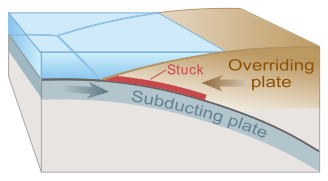
Tsunamis can be generated when the sea floor abruptly deforms and vertically displaces the overlying water. Tectonic earthquakes are a particular kind of earthquake that are associated with the Earth’s crustal deformation; when these earthquakes occur beneath the sea, the water above the deformed area is displaced from its equilibrium position.[34] More specifically, a tsunami can be generated when thrust faults associated with convergent or destructive plate boundaries move abruptly, resulting in water displacement, owing to the vertical component of movement involved. Movement on normal (extensional) faults can also cause displacement of the seabed, but only the largest of such events (typically related to flexure in the outer trench swell) cause enough displacement to give rise to a significant tsunami, such as the 1977 Sumba and 1933 Sanriku events.[35][36]
-

-

Plate slips, causing subsidence and releasing energy into water.
-

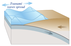
The energy released produces tsunami waves.

Tsunamis have a small wave height offshore, and a very long wavelength (often hundreds of kilometres long, whereas normal ocean waves have a wavelength of only 30 or 40 metres),[37] which is why they generally pass unnoticed at sea, forming only a slight swell usually about 300 millimetres (12 in) above the normal sea surface. They grow in height when they reach shallower water, in a wave shoaling process described below. A tsunami can occur in any tidal state and even at low tide can still inundate coastal areas.
On April 1, 1946, the 8.6 Mw Aleutian Islands earthquake occurred with a maximum Mercalli intensity of VI (Strong). It generated a tsunami which inundated Hilo on the island of Hawaii with a 14-metre high (46 ft) surge. Between 165 and 173 were killed. The area where the earthquake occurred is where the Pacific Ocean floor is subducting (or being pushed downwards) under Alaska.
Examples of tsunamis originating at locations away from convergent boundaries include Storegga about 8,000 years ago, Grand Banks in 1929, and Papua New Guinea in 1998 (Tappin, 2001). The Grand Banks and Papua New Guinea tsunamis came from earthquakes which destabilised sediments, causing them to flow into the ocean and generate a tsunami. They dissipated before travelling transoceanic distances.
The cause of the Storegga sediment failure is unknown. Possibilities include an overloading of the sediments, an earthquake or a release of gas hydrates (methane etc.).
The 1960 Valdivia earthquake (Mw 9.5), 1964 Alaska earthquake (Mw 9.2), 2004 Indian Ocean earthquake (Mw 9.2), and 2011 Tōhoku earthquake (Mw9.0) are recent examples of powerful megathrust earthquakes that generated tsunamis (known as teletsunamis) that can cross entire oceans. Smaller (Mw 4.2) earthquakes in Japan can trigger tsunamis (called local and regional tsunamis) that can devastate stretches of coastline, but can do so in only a few minutes at a time.
Landslides
The Tauredunum event was a large tsunami on Lake Geneva in 563 CE, caused by sedimentary deposits destabilized by a landslide.
In the 1950s, it was discovered that tsunamis larger than had previously been believed possible can be caused by giant submarine landslides. These large volumes of rapidly displaced water transfer energy at a faster rate than the water can absorb. Their existence was confirmed in 1958, when a giant landslide in Lituya Bay, Alaska, caused the highest wave ever recorded, which had a height of 524 metres (1,719 ft).[38] The wave did not travel far as it struck land almost immediately. The wave struck three boats—each with two people aboard—anchored in the bay. One boat rode out the wave, but the wave sank the other two, killing both people aboard one of them.[39][40][41]
Another landslide-tsunami event occurred in 1963 when a massive landslide from Monte Toc entered the reservoir behind the Vajont Dam in Italy. The resulting wave surged over the 262-metre (860 ft)-high dam by 250 metres (820 ft) and destroyed several towns. Around 2,000 people died.[42][43] Scientists named these waves megatsunamis.
Some geologists claim that large landslides from volcanic islands, e.g. Cumbre Vieja on La Palma (Cumbre Vieja tsunami hazard) in the Canary Islands, may be able to generate megatsunamis that can cross oceans, but this is disputed by many others.
In general, landslides generate displacements mainly in the shallower parts of the coastline, and there is conjecture about the nature of large landslides that enter the water. This has been shown to subsequently affect water in enclosed bays and lakes, but a landslide large enough to cause a transoceanic tsunami has not occurred within recorded history. Susceptible locations are believed to be the Big Island of Hawaii, Fogo in the Cape Verde Islands, La Reunion in the Indian Ocean, and Cumbre Vieja on the island of La Palma in the Canary Islands; along with other volcanic ocean islands. This is because large masses of relatively unconsolidated volcanic material occurs on the flanks and in some cases detachment planes are believed to be developing. However, there is growing controversy about how dangerous these slopes actually are.[44]
Volcanic eruptions
Other than by landslides or sector collapse, volcanoes may be able to generate waves by pyroclastic flow submergence, caldera collapse, or underwater explosions.[45] Tsunamis have been triggered by a number of volcanic eruptions, including the 1883 eruption of Krakatoa, and the 2022 Hunga Tonga–Hunga Ha’apai eruption. Over 20% of all fatalities caused by volcanism during the past 250 years are estimated to have been caused by volcanogenic tsunamis.[46]
Debate has persisted over the origins and source mechanisms of these types of tsunamis, such as those generated by Krakatoa in 1883,[46] and they remain lesser understood than their seismic relatives. This poses a large problem of awareness and preparedness, as exemplified by the eruption and collapse of Anak Krakatoa in 2018, which killed 426 and injured thousands when no warning was available.
It is still regarded that lateral landslides and ocean-entering pyroclastic currents are most likely to generate the largest and most hazardous waves from volcanism;[47] however, field investigation of the Tongan event, as well as developments in numerical modelling methods, currently aim to expand the understanding of the other source mechanisms.[48][49]
Meteorological
Some meteorological conditions, especially rapid changes in barometric pressure, as seen with the passing of a front, can displace bodies of water enough to cause trains of waves with wavelengths. These are comparable to seismic tsunamis, but usually with lower energies. Essentially, they are dynamically equivalent to seismic tsunamis, the only differences being 1) that meteotsunamis lack the transoceanic reach of significant seismic tsunamis, and 2) that the force that displaces the water is sustained over some length of time such that meteotsunamis cannot be modelled as having been caused instantaneously. In spite of their lower energies, on shorelines where they can be amplified by resonance, they are sometimes powerful enough to cause localised damage and potential for loss of life. They have been documented in many places, including the Great Lakes, the Aegean Sea, the English Channel, and the Balearic Islands, where they are common enough to have a local name, rissaga. In Sicily they are called marubbio and in Nagasaki Bay, they are called abiki. Some examples of destructive meteotsunamis include 31 March 1979 at Nagasaki and 15 June 2006 at Menorca, the latter causing damage in the tens of millions of euros.[50]
Meteotsunamis should not be confused with storm surges, which are local increases in sea level associated with the low barometric pressure of passing tropical cyclones, nor should they be confused with setup, the temporary local raising of sea level caused by strong on-shore winds. Storm surges and setup are also dangerous causes of coastal flooding in severe weather but their dynamics are completely unrelated to tsunami waves.[50] They are unable to propagate beyond their sources, as waves do.
Man-made or triggered tsunamis
The accidental Halifax Explosion in 1917 triggered a 18-meter high Tsunami in the harbour.
There have been studies of the potential of the induction of and at least one actual attempt to create tsunami waves as a tectonic weapon.
In World War II, the New Zealand Military Forces initiated Project Seal, which attempted to create small tsunamis with explosives in the area of today’s Shakespear Regional Park; the attempt failed.[51]
There has been considerable speculation on the possibility of using nuclear weapons to cause tsunamis near an enemy coastline. Even during World War II consideration of the idea using conventional explosives was explored. Nuclear testing in the Pacific Proving Ground by the United States seemed to generate poor results. Operation Crossroads fired two 20 kilotonnes of TNT (84 TJ) bombs, one in the air and one underwater, above and below the shallow (50 m (160 ft)) waters of the Bikini Atoll lagoon. Fired about 6 km (3.7 mi) from the nearest island, the waves there were no higher than 3–4 m (9.8–13.1 ft) upon reaching the shoreline. Other underwater tests, mainly Hardtack I/Wahoo (deep water) and Hardtack I/Umbrella (shallow water) confirmed the results. Analysis of the effects of shallow and deep underwater explosions indicate that the energy of the explosions does not easily generate the kind of deep, all-ocean waveforms which are tsunamis; most of the energy creates steam, causes vertical fountains above the water, and creates compressional waveforms.[52] Tsunamis are hallmarked by permanent large vertical displacements of very large volumes of water which do not occur in explosions.
Characteristics

When the wave enters shallow water, it slows down and its amplitude (height) increases.

The wave further slows and amplifies as it hits land. Only the largest waves crest.
Tsunamis are caused by earthquakes, landslides, volcanic explosions, glacier calvings, and bolides. They cause damage by two mechanisms: the smashing force of a wall of water travelling at high speed, and the destructive power of a large volume of water draining off the land and carrying a large amount of debris with it, even with waves that do not appear to be large.
While everyday wind waves have a wavelength (from crest to crest) of about 100 metres (330 ft) and a height of roughly 2 metres (6.6 ft), a tsunami in the deep ocean has a much larger wavelength of up to 200 kilometres (120 mi). Such a wave travels at well over 800 kilometres per hour (500 mph), but owing to the enormous wavelength the wave oscillation at any given point takes 20 or 30 minutes to complete a cycle and has an amplitude of only about 1 metre (3.3 ft).[53] This makes tsunamis difficult to detect over deep water, where ships are unable to feel their passage.
The velocity of a tsunami can be calculated by obtaining the square root of the depth of the water in metres multiplied by the acceleration due to gravity (approximated to 10 m/s2). For example, if the Pacific Ocean is considered to have a depth of 5000 metres, the velocity of a tsunami would be √5000 × 10 = √50000 ≈ 224 metres per second (730 ft/s), which equates to a speed of about 806 kilometres per hour (501 mph). This is the formula used for calculating the velocity of shallow-water waves. Even the deep ocean is shallow in this sense because a tsunami wave is so long (horizontally from crest to crest) by comparison.
The reason for the Japanese name «harbour wave» is that sometimes a village’s fishermen would sail out, and encounter no unusual waves while out at sea fishing, and come back to land to find their village devastated by a huge wave.
As the tsunami approaches the coast and the waters become shallow, wave shoaling compresses the wave and its speed decreases below 80 kilometres per hour (50 mph). Its wavelength diminishes to less than 20 kilometres (12 mi) and its amplitude grows enormously—in accord with Green’s law. Since the wave still has the same very long period, the tsunami may take minutes to reach full height. Except for the very largest tsunamis, the approaching wave does not break, but rather appears like a fast-moving tidal bore.[54] Open bays and coastlines adjacent to very deep water may shape the tsunami further into a step-like wave with a steep-breaking front.
When the tsunami’s wave peak reaches the shore, the resulting temporary rise in sea level is termed run up. Run up is measured in metres above a reference sea level.[54] A large tsunami may feature multiple waves arriving over a period of hours, with significant time between the wave crests. The first wave to reach the shore may not have the highest run-up.[55]
About 80% of tsunamis occur in the Pacific Ocean, but they are possible wherever there are large bodies of water, including lakes. However, tsunami interactions with shorelines and the seafloor topography are extremely complex, which leaves some countries more vulnerable than others. For example, the Pacific coasts of the United States and Mexico lie adjacent to each other, but the United States has recorded ten tsunamis in the region since 1788, while Mexico has recorded twenty-five since 1732.[56][57] Similarly, Japan has had more than a hundred tsunamis in recorded history, while the neighboring island of Taiwan has registered only two, in 1781 and 1867.[58][59]
Drawback

An illustration of the rhythmic «drawback» of surface water associated with a wave. It follows that a very large drawback may herald the arrival of a very large wave.
All waves have a positive and negative peak; that is, a ridge and a trough. In the case of a propagating wave like a tsunami, either may be the first to arrive. If the first part to arrive at the shore is the ridge, a massive breaking wave or sudden flooding will be the first effect noticed on land. However, if the first part to arrive is a trough, a drawback will occur as the shoreline recedes dramatically, exposing normally submerged areas. The drawback can exceed hundreds of metres, and people unaware of the danger sometimes remain near the shore to satisfy their curiosity or to collect fish from the exposed seabed.
A typical wave period for a damaging tsunami is about twelve minutes. Thus, the sea recedes in the drawback phase, with areas well below sea level exposed after three minutes. For the next six minutes, the wave trough builds into a ridge which may flood the coast, and destruction ensues. During the next six minutes, the wave changes from a ridge to a trough, and the flood waters recede in a second drawback. Victims and debris may be swept into the ocean. The process repeats with succeeding waves.
Scales of intensity and magnitude
As with earthquakes, several attempts have been made to set up scales of tsunami intensity or magnitude to allow comparison between different events.[60]
Intensity scales
The first scales used routinely to measure the intensity of tsunamis were the Sieberg-Ambraseys scale (1962), used in the Mediterranean Sea and the Imamura-Iida intensity scale (1963), used in the Pacific Ocean. The latter scale was modified by Soloviev (1972), who calculated the tsunami intensity «I» according to the formula:

where  is the «tsunami height» in meters, averaged along the nearest coastline, with the tsunami height defined as the rise of the water level above the normal tidal level at the time of occurrence of the tsunami.[61] This scale, known as the Soloviev-Imamura tsunami intensity scale, is used in the global tsunami catalogues compiled by the NGDC/NOAA[62] and the Novosibirsk Tsunami Laboratory as the main parameter for the size of the tsunami.
This formula yields:
In 2013, following the intensively studied tsunamis in 2004 and 2011, a new 12-point scale was proposed, the Integrated Tsunami Intensity Scale (ITIS-2012), intended to match as closely as possible to the modified ESI2007 and EMS earthquake intensity scales.[63][64]
Magnitude scales
The first scale that genuinely calculated a magnitude for a tsunami, rather than an intensity at a particular location was the ML scale proposed by Murty & Loomis based on the potential energy.[60] Difficulties in calculating the potential energy of the tsunami mean that this scale is rarely used. Abe introduced the tsunami magnitude scale  , calculated from,

where h is the maximum tsunami-wave amplitude (in m) measured by a tide gauge at a distance R from the epicentre, a, b and D are constants used to make the Mt scale match as closely as possible with the moment magnitude scale.[65]
Tsunami heights
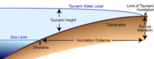
Diagram showing several measures to describe a tsunami size, including height, inundation and run-up.
Several terms are used to describe the different characteristics of tsunami in terms of their height:[66][67][68][69]
- Amplitude, Wave Height, or Tsunami Height: Refers to the height of a tsunami relative to the normal sea level at the time of the tsunami, which may be tidal High Water, or Low Water. It is different from the crest-to-trough height which is commonly used to measure other type of wave height.[70]
- Run-up Height, or Inundation Height: The height reached by a tsunami on the ground above sea level, Maximum run-up height refers to the maximum height reached by water above sea level, which is sometimes reported as the maximum height reached by a tsunami.
- Flow Depth: Refers to the height of tsunami above ground, regardless of the height of the location or sea level.
- (Maximum) Water Level: Maximum height above sea level as seen from trace or water mark. Different from maximum run-up height in the sense that they are not necessarily water marks at inundation line/limit.
Warnings and predictions

Calculated travel time map for the 1964 Alaska tsunami (in hours)
Drawbacks can serve as a brief warning. People who observe drawback (many survivors report an accompanying sucking sound), can survive only if they immediately run for high ground or seek the upper floors of nearby buildings.
In 2004, ten-year-old Tilly Smith of Surrey, England, was on Maikhao beach in Phuket, Thailand with her parents and sister, and having learned about tsunamis recently in school, told her family that a tsunami might be imminent. Her parents warned others minutes before the wave arrived, saving dozens of lives. She credited her geography teacher, Andrew Kearney.
In the 2004 Indian Ocean tsunami drawback was not reported on the African coast or any other east-facing coasts that it reached. This was because the initial wave moved downwards on the eastern side of the megathrust and upwards on the western side. The western pulse hit coastal Africa and other western areas.
A tsunami cannot be precisely predicted, even if the magnitude and location of an earthquake is known. Geologists, oceanographers, and seismologists analyse each earthquake and based on many factors may or may not issue a tsunami warning. However, there are some warning signs of an impending tsunami, and automated systems can provide warnings immediately after an earthquake in time to save lives. One of the most successful systems uses bottom pressure sensors, attached to buoys, which constantly monitor the pressure of the overlying water column.
Regions with a high tsunami risk typically use tsunami warning systems to warn the population before the wave reaches land. On the west coast of the United States, which is prone to tsunamis from the Pacific Ocean, warning signs indicate evacuation routes. In Japan, the populace is well-educated about earthquakes and tsunamis, and along Japanese shorelines, tsunami warning signs remind people of the natural hazards along with a network of warning sirens, typically at the top of the cliffs of surrounding hills.[71]
The Pacific Tsunami Warning System is based in Honolulu, Hawaiʻi. It monitors Pacific Ocean seismic activity. A sufficiently large earthquake magnitude and other information triggers a tsunami warning. While the subduction zones around the Pacific are seismically active, not all earthquakes generate a tsunami. Computers assist in analysing the tsunami risk of every earthquake that occurs in the Pacific Ocean and the adjoining land masses.
-

A tsunami warning sign in Kamakura, Japan
-

A Tsunami hazard sign (Spanish — English) in Iquique, Chile.


As a direct result of the Indian Ocean tsunami, a re-appraisal of the tsunami threat for all coastal areas is being undertaken by national governments and the United Nations Disaster Mitigation Committee. A tsunami warning system is being installed in the Indian Ocean.

One of the deep water buoys used in the DART tsunami warning system
Computer models can predict tsunami arrival, usually within minutes of the arrival time. Bottom pressure sensors can relay information in real time. Based on these pressure readings and other seismic information and the seafloor’s shape (bathymetry) and coastal topography, the models estimate the amplitude and surge height of the approaching tsunami. All Pacific Rim countries collaborate in the Tsunami Warning System and most regularly practise evacuation and other procedures. In Japan, such preparation is mandatory for government, local authorities, emergency services and the population.
Along the United States west coast, in addition to sirens, warnings are sent on television and radio via the National Weather Service, using the Emergency Alert System.
Possible animal reaction
Some zoologists hypothesise that some animal species have an ability to sense subsonic Rayleigh waves from an earthquake or a tsunami. If correct, monitoring their behaviour could provide advance warning of earthquakes and tsunamis. However, the evidence is controversial and is not widely accepted. There are unsubstantiated claims about the Lisbon quake that some animals escaped to higher ground, while many other animals in the same areas drowned. The phenomenon was also noted by media sources in Sri Lanka in the 2004 Indian Ocean earthquake.[72][73] It is possible that certain animals (e.g., elephants) may have heard the sounds of the tsunami as it approached the coast. The elephants’ reaction was to move away from the approaching noise. By contrast, some humans went to the shore to investigate and many drowned as a result.
Mitigation
In some tsunami-prone countries, earthquake engineering measures have been taken to reduce the damage caused onshore.
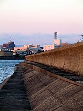
Japan, where tsunami science and response measures first began following a disaster in 1896, has produced ever-more elaborate countermeasures and response plans.[74] The country has built many tsunami walls of up to 12 metres (39 ft) high to protect populated coastal areas. Other localities have built floodgates of up to 15.5 metres (51 ft) high and channels to redirect the water from an incoming tsunami. However, their effectiveness has been questioned, as tsunamis often overtop the barriers.
The Fukushima Daiichi nuclear disaster was directly triggered by the 2011 Tōhoku earthquake and tsunami, when waves exceeded the height of the plant’s sea wall.[75] Iwate Prefecture, which is an area at high risk from tsunami, had tsunami barriers walls (Taro sea wall) totalling 25 kilometres (16 mi) long at coastal towns. The 2011 tsunami toppled more than 50% of the walls and caused catastrophic damage.[76]
The Okushiri, Hokkaidō tsunami which struck Okushiri Island of Hokkaidō within two to five minutes of the earthquake on July 12, 1993, created waves as much as 30 metres (100 ft) tall—as high as a 10-storey building. The port town of Aonae was completely surrounded by a tsunami wall, but the waves washed right over the wall and destroyed all the wood-framed structures in the area. The wall may have succeeded in slowing down and moderating the height of the tsunami, but it did not prevent major destruction and loss of life.[77]
See also
- Emergency management – Dealing with all humanitarian aspects of emergencies
- Higher Ground Project – Worldwide campaign to celebrate the children who survived the 2004 Indian Ocean earthquake tsunami
- Index of wave articles
- Kaikoura Canyon landslide tsunami hazard – peninsular mountain on New Zealand’s South Island
- List of tsunamis
- List of natural disasters by death toll
- Lists of earthquakes
- Minoan eruption – Major volcanic eruption around 1600 BCE
- Rogue wave – Unexpectedly large transient ocean surface wave
- Seiche – Standing wave in an enclosed or partially enclosed body of water
- Sneaker wave – Disproportionately large coastal wave
- Supervolcano – Volcano that has erupted 1000 cubic km of lava in a single eruption
- Tauredunum event – Ancient Tsunami on Lake Geneva
- Tsunami-proof building – purposefully designed building which will, through its design integrity, withstand and survive the forces of a tsunami wave or extreme storm surge
- List of tsunamis affecting New Zealand
Footnotes
- ^ Wells, John C. (1990). Longman pronunciation dictionary. Harlow, England: Longman. p. 736. ISBN 978-0-582-05383-0. Entry: «tsunami»
- ^ «tsunami». Macmillan Dictionary. Retrieved 2018-11-23.
- ^ «tsunami». Merriam-Webster Dictionary. Retrieved 19 August 2019.
- ^ «tsunami». Longman Dictionary of Contemporary English. Longman. Retrieved 19 August 2019.
- ^ «Tsunami Terminology». NOAA. Archived from the original on 2011-02-25. Retrieved 2010-07-15.
- ^ Barbara Ferreira (April 17, 2011). «When icebergs capsize, tsunamis may ensue». Nature. Archived from the original on 2011-11-04. Retrieved 2011-04-27.
- ^ «NASA Finds Japan Tsunami Waves Merged, Doubling Power». Jet Propulsion Laboratory. Retrieved 3 November 2016.
- ^ «Tsunami 101». University of Washington. Retrieved 1 December 2018.
- ^ «Definition of Tidal Wave».
- ^ «What does «tsunami» mean?». Earth and Space Sciences, University of Washington. Retrieved 1 December 2018.
- ^ Fradin, Judith Bloom and Dennis Brindell (2008). Witness to Disaster: Tsunamis. Witness to Disaster. Washington, D.C.: National Geographic Society. pp. 42–43. Archived from the original on 2012-04-06.
- ^ a b Thucydides: “A History of the Peloponnesian War”, 3.89.1–4
- ^ a b c Smid, T. C. (April 1970). ‘Tsunamis’ in Greek Literature. Greece & Rome. Vol. 17 (2nd ed.). pp. 100–104.
- ^ [a. Jap. tsunami, tunami, f. tsu harbour + nami waves.—Oxford English Dictionary]
- ^ «Definition of Tidal Wave». Retrieved 3 November 2016.
- ^ «Tidal», The American Heritage Stedman’s Medical Dictionary. Houghton Mifflin Company. 11 November 2008.Dictionary.reference.com
- ^ -al. (n.d.). Dictionary.com Unabridged (v 1.1). Retrieved November 11, 2008, Dictionary.reference.com
- ^ «Forty Feet High and It Kills!» Hawaii Five-O. Writ. Robert C. Dennis and Edward J. Lakso. Dir. Michael O’Herlihy. CBS, 8 Oct. 1969. Television.
- ^ «Seismic Sea Wave – Tsunami Glossary». Retrieved 3 November 2016.
- ^ «tsunamis». Retrieved 3 November 2016.
- ^ postcode=3001, corporateName=Bureau of Meteorology; address=GPO Box 1289, Melbourne, Victoria, Australia. «Joint Australian Tsunami Warning Centre». Retrieved 3 November 2016.
- ^ Indian Ocean tsunami anniversary: Memorial events held 26 December 2014, BBC News
- ^ The 10 most destructive tsunamis in history Archived 2013-12-04 at the Wayback Machine, Australian Geographic, March 16, 2011.
- ^ Thucydides: “A History of the Peloponnesian War”, 3.89.5
- ^ Kelly, Gavin (2004). «Ammianus and the Great Tsunami». The Journal of Roman Studies. 94 (141): 141–167. doi:10.2307/4135013. hdl:20.500.11820/635a4807-14c9-4044-9caa-8f8e3005cb24. JSTOR 4135013. S2CID 160152988.
- ^ Stanley, Jean-Daniel & Jorstad, Thomas F. (2005), «The 365 A.D. Tsunami Destruction of Alexandria, Egypt: Erosion, Deformation of Strata and Introduction of Allochthonous Material Archived 2017-05-25 at the Wayback Machine»
- ^ Haugen, K; Lovholt, F; Harbitz, C (2005). «Fundamental mechanisms for tsunami generation by submarine mass flows in idealised geometries». Marine and Petroleum Geology. 22 (1–2): 209–217. doi:10.1016/j.marpetgeo.2004.10.016.
- ^ «Tsunami Locations & Occurrences». National Weather Service. Retrieved 16 January 2022.
- ^ Krieger, Lisa M. (15 January 2022). «Volcanic tsunamis: Why they are so difficult to predict». The Mercury News. Retrieved 16 January 2022.
- ^ «Tsunamis». National Geographic. Retrieved 16 January 2022.
- ^ Margaritondo, G (2005). «Explaining the physics of tsunamis to undergraduate and non-physics students» (PDF). European Journal of Physics. 26 (3): 401–407. Bibcode:2005EJPh…26..401M. doi:10.1088/0143-0807/26/3/007. S2CID 7512603. Archived from the original (PDF) on 2019-02-19.
- ^ Voit, S.S (1987). «Tsunamis». Annual Review of Fluid Mechanics. 19 (1): 217–236. Bibcode:1987AnRFM..19..217V. doi:10.1146/annurev.fl.19.010187.001245.
- ^ Tia Ghose (2014). «Are Ocean Asteroid Impacts Really a Serious Threat?».
- ^ «How do earthquakes generate tsunamis?». University of Washington. Archived from the original on 2007-02-03.
- ^ Lynnes, C. S.; Lay, T. (1988), «Source Process of the Great 1977 Sumba Earthquake» (PDF), Geophysical Research Letters, American Geophysical Union, 93 (B11): 13, 407–13, 420, Bibcode:1988JGR….9313407L, doi:10.1029/JB093iB11p13407
- ^ Kanamori H. (1971). «Seismological evidence for a lithospheric normal faulting – the Sanriku earthquake of 1933». Physics of the Earth and Planetary Interiors. 4 (4): 298–300. Bibcode:1971PEPI….4..289K. doi:10.1016/0031-9201(71)90013-6.
- ^ Facts and figures: how tsunamis form Archived 2013-11-05 at the Wayback Machine, Australian Geographic, March 18, 2011.
- ^ George Pararas-Carayannis (1999). «The Mega-Tsunami of July 9, 1958 in Lituya Bay, Alaska». Retrieved 2014-02-27.
- ^ «alaskashipwreck.com Alaska Shipwrecks (B)».
- ^ «alaskashipwreck.com Alaska Shipwrecks (S)».
- ^ «Dickson, Ian, «60 Years Ago: The 1958 Earthquake and Lituya Bay Megatsunami,» University of Alaska Fairbanks Alaska Earthquake Center, July 13, 2018 Retrieved December 2, 2018″.
- ^ Petley, Dave (Professor) (2008-12-11). «The Vaiont (Vajont) landslide of 1963». The Landslide Blog. Archived from the original on 2013-12-06. Retrieved 2014-02-26.
- ^ Duff, Mark (2013-10-10). «Italy Vajont anniversary: Night of the ‘tsunami’«. BBC News. Bbc.co.uk. Retrieved 2014-02-27.
- ^ Pararas-Carayannis, George (2002). «Evaluation of the threat of mega tsunami generation from postulated massive slope failures of the island volcanoes on La Palma, Canary Islands, and on the island of Hawaii». Science of Tsunami Hazards. 20 (5): 251–277. Retrieved 7 September 2014.
- ^ Paris, R. (2015). «Source mechanisms of volcanic tsunamis». Phil. Trans. R. Soc. 373 (2053). Bibcode:2015RSPTA.37340380P. doi:10.1098/rsta.2014.0380. PMID 26392617. S2CID 43187708.
- ^ a b Latter, J. H. (1981). «Tsunamis of volcanic origin: Summary of causes, with particular reference to Krakatoa, 1883». Bulletin Volcanologique. 44 (3): 467–490. Bibcode:1981BVol…44..467L. doi:10.1007/BF02600578. S2CID 129637214.
- ^ Day, Simon J. (2015). «Volcanic Tsunamis». The Encyclopedia of Volcanoes. Elsevier. pp. 993–1009. doi:10.1016/B978-0-12-385938-9.00058-4. ISBN 9780123859389. Retrieved 2022-03-21.
- ^ Hayward, Matthew. W.; Whittaker, C. N.; Lane, E. M.; Power, W. L.; Popinet, S.; White, J.D.L. (2022). «Multilayer modelling of waves generated by explosive subaqueous volcanism». Natural Hazards and Earth System Sciences. 22 (2): 617–637. Bibcode:2022NHESS..22..617H. doi:10.5194/nhess-22-617-2022.
- ^ Battershill, L. (2021). «Numerical Simulations of a Fluidized Granular Flow Entry Into Water: Insights Into Modeling Tsunami Generation by Pyroclastic Density Currents». Journal of Geophysical Research: Solid Earth. 126 (11). Bibcode:2021JGRB..12622855B. doi:10.1029/2021JB022855. S2CID 243837214.[permanent dead link]
- ^ a b Monserrat, S.; Vilibíc, I.; Rabinovich, A. B. (2006). «Meteotsunamis: atmospherically induced destructive ocean waves in the tsunami frequency band» (PDF). Natural Hazards and Earth System Sciences. 6 (6): 1035–1051. Bibcode:2006NHESS…6.1035M. doi:10.5194/nhess-6-1035-2006. Retrieved 23 November 2011.
- ^ «The Hauraki Gulf Marine Park, Part 2». Inset to The New Zealand Herald. 3 March 2010. p. 9.
- ^ Glasstone, Samuel; Dolan, Philip (1977). Shock effects of surface and subsurface bursts – The effects of nuclear weapons (third ed.). Washington, DC: U.S. Department of Defense; Energy Research and Development Administration.
- ^ Earthsci.org, Tsunamis
- ^ a b «Life of a Tsunami». Western Coastal & Marine Geology. United States Geographical Survey. 22 October 2008. Retrieved 2009-09-09.
- ^ Prof. Stephen A. Nelson (28 January 2009). «Tsunami». Tulane University. Retrieved 2009-09-09.
- ^ «Tsunamis in the United States». WorldData.
- ^ «Tsunamis in Mexico». WorldData.
- ^ «Tsunamis in Japan». Worlddata.info.
- ^ «Tsunamis in Taiwan». Worlddata.info.
- ^ a b Gusiakov V. «Tsunami Quantification: how we measure the overall size of tsunami (Review of tsunami intensity and magnitude scales)» (PDF). Retrieved 2009-10-18.
- ^ Soloviev, S., & Go, N., 1974 (English transl. 1984), “Catalogue of tsunamis on the western shore of the Pacific Ocean”, Canadian Translation of Fisheries and Aquatic Sciences, No. 5077, (310 p).
- ^ Center, National Geophysical Data. «NGDC/WDS Global Historical Tsunami Database – NCEI». Retrieved 3 November 2016.
- ^ Lekkas E.; Andreadakis E.; Kostaki I. & Kapourani E. (2013). «A Proposal for a New Integrated Tsunami Intensity Scale (ITIS‐2012)». Bulletin of the Seismological Society of America. 103 (2B): 1493–1502. Bibcode:2013BuSSA.103.1493L. doi:10.1785/0120120099.
- ^ Katsetsiadou, K.N., Andreadakis, E. and Lekkas, E., 2016. Tsunami intensity mapping: applying the integrated Tsunami Intensity Scale (ITIS2012) on Ishinomaki Bay Coast after the mega-tsunami of Tohoku, March 11, 2011. Research in Geophysics, 5(1).
- ^ Abe K. (1995). Estimate of Tsunami Run-up Heights from Earthquake Magnitudes. Tsunami: progress in prediction, disaster prevention, and warning. ISBN 978-0-7923-3483-5. Retrieved 2009-10-18.
- ^ «Tsunami Glossary».
- ^ «Tsunami Terms».
- ^ «津波について».
- ^ «津波の高さの定義». Retrieved 2012-02-19.[dead link]
- ^ «Tsunami Amplitude».
- ^ Chanson, H. (2010). «Tsunami Warning Signs on the Enshu Coast of Japan». Shore & Beach. 78 (1): 52–54. ISSN 0037-4237.
- ^ Lambourne, Helen (2005-03-27). «Tsunami: Anatomy of a disaster». BBC.
- ^ Kenneally, Christine (2004-12-30). «Surviving the Tsunami: What Sri Lanka’s animals knew that humans didn’t». Slate Magazine.
- ^ «Journalist’s Resource: Research for Reporting, from Harvard Shorenstein Center». Content.hks.harvard.edu. 2012-05-30. Retrieved 2012-06-12.
- ^ Phillip Lipscy, Kenji Kushida, and Trevor Incerti. 2013. «The Fukushima Disaster and Japan’s Nuclear Plant Vulnerability in Comparative Perspective Archived 2013-10-29 at the Wayback Machine». Environmental Science and Technology 47 (May), 6082–6088.
- ^ Fukada, Takahiro (21 September 2011). «Iwate fisheries continue struggle to recover». The Japan Times. p. 3. Retrieved 2016-09-18.
- ^ George Pararas-Carayannis. «The Earthquake and Tsunami of July 12, 1993 in the Sea of Japan/East Sea». www.drgeorgepc.com. Retrieved 2016-09-18.
References
- IOC Tsunami Glossary by the Intergovernmental Oceanographic Commission (IOC) at the International Tsunami Information Centre (ITIC) of UNESCO
- Tsunami Terminology at NOAA
- In June 2011, the VOA Special English service of the Voice of America broadcast a 15-minute program on tsunamis as part of its weekly Science in the News series. The program included an interview with an NOAA official who oversees the agency’s tsunami warning system. A transcript and MP3 of the program, intended for English learners, can be found at The Ever-Present Threat of Tsunamis.
- abelard.org. tsunamis: tsunamis travel fast but not at infinite speed. retrieved March 29, 2005.
- Dudley, Walter C. & Lee, Min (1988: 1st edition) Tsunami! ISBN 0-8248-1125-9 website
- Iwan, W.D., editor, 2006, Summary report of the Great Sumatra Earthquakes and Indian Ocean tsunamis of December 26, 2004 and March 28, 2005: Earthquake Engineering Research Institute, EERI Publication #2006-06, 11 chapters, 100-page summary, plus CD-ROM with complete text and supplementary photographs, EERI Report 2006–06. ISBN 1-932884-19-X website
- Kenneally, Christine (December 30, 2004). «Surviving the Tsunami.» Slate. website
- Lambourne, Helen (March 27, 2005). «Tsunami: Anatomy of a disaster.» BBC News. website
- Macey, Richard (January 1, 2005). «The Big Bang that Triggered A Tragedy,» The Sydney Morning Herald, p 11—quoting Dr Mark Leonard, seismologist at Geoscience Australia.
- Interactive Map of Historical Tsunamis from NOAA National Centers for Environmental Information
- Tappin, D; 2001. Local tsunamis. Geoscientist. 11–8, 4–7.
- Girl, 10, used geography lesson to save lives, Telegraph.co.uk
- Philippines warned to prepare for Japan’s tsunami, Noypi.ph
Further reading
- Boris Levin, Mikhail Nosov: Physics of tsunamis. Springer, Dordrecht 2009, ISBN 978-1-4020-8855-1.
- Kontar, Y. A. et al.: Tsunami Events and Lessons Learned: Environmental and Societal Significance. Springer, 2014. ISBN 978-94-007-7268-7 (print); ISBN 978-94-007-7269-4 (eBook)
- Kristy F. Tiampo: Earthquakes: simulations, sources and tsunamis. Birkhäuser, Basel 2008, ISBN 978-3-7643-8756-3.
- Linda Maria Koldau: Tsunamis. Entstehung, Geschichte, Prävention, (Tsunami development, history and prevention) C.H. Beck, Munich 2013 (C.H. Beck Reihe Wissen 2770), ISBN 978-3-406-64656-0 (in German).
- Walter C. Dudley, Min Lee: Tsunami! University of Hawaii Press, 1988, 1998, Tsunami! University of Hawai’i Press 1999, ISBN 0-8248-1125-9, ISBN 978-0-8248-1969-9.
- Charles L. Mader: Numerical Modeling of Water Waves CRC Press, 2004, ISBN 0-8493-2311-8.
External links
![]()
Look up tsunami in Wiktionary, the free dictionary.
![]()
Wikimedia Commons has media related to Tsunamis.
- World’s Tallest Tsunami – geology.com
- Tsunami Data and Information – National Centers for Environmental Information
- IOC Tsunami Glossary – International Tsunami Information Center (UNESCO)
- Tsunami & Earthquake Research at the USGS – United States Geological Survey
- Intergovernmental Oceanographic Commission – Intergovernmental Oceanographic Commission
- Tsunami – National Oceanic and Atmospheric Administration
- Wave That Shook The World – Nova
- Recent and Historical Tsunami Events and Relevant Data – Pacific Marine Environmental Laboratory
- Raw Video: Tsunami Slams Northeast Japan – Associated Press
- Tsunami alert page (in English) from Japan Meteorological Agency
- Tsunami animation – Geoscience Australia
Last Update: Jan 03, 2023
This is a question our experts keep getting from time to time. Now, we have got the complete detailed explanation and answer for everyone, who is interested!
Asked by: Triston Larson IV
Score: 4.4/5
(36 votes)
Tsunami is a Japanese word from a double root: tsu, meaning port or harbour, and nami, meaning wave. The word looks innocuous in simple translation, but to those who live on the rim of the Pacific it can spell disaster. … Tsunamis are fast moving ocean waves which spread across the open water like ripples oh a pond.
What does tsunami literally mean?
Tsunami (soo-NAH-mee) is a Japanese word meaning harbour wave. A tsunami is a series of waves with a long wavelength and period (time between crests). … Tsunamis are often incorrectly called tidal waves; they have no relation to the daily ocean tides.
How did tsunami get its name?
The word tsunami (pronounced tsoo-nah’-mee) is composed of the Japanese words «tsu» (which means harbor) and «nami» (which means «wave»). … Thus, the Japanese word «tsunami», meaning «harbor wave» is the correct, official and all-inclusive term.
What does the word tsunami mean Class 7?
Tsunami is a Japanese word that means ‘harbor waves’ as the harbors get destroyed whenever there is a tsunami. An earthquake, a volcanic eruption or underwater landslides can shift large amounts of ocean water. As a result tsunami occurs which may be as high as 15 m. The tsunami of 2004 is still in our minds.
Is tsunami a English word?
The word «tsunami» is originally a Japanese word, but today it’s commonly used in English. … That’s when an earthquake struck off the east coast of Japan, very close to where the recent tsunami hit.
33 related questions found
What language is tsunami?
Tsunami is a Japanese word from a double root: tsu, meaning port or harbour, and nami, meaning wave.
What was the biggest tsunami?
Lituya Bay, Alaska, July 9, 1958
Its over 1,700-foot wave was the largest ever recorded for a tsunami. It inundated five square miles of land and cleared hundreds of thousands of trees. Remarkably, only two fatalities occurred.
What are the types of tsunami?
There are two types of tsunami generation: Local tsunami and Far Field or distant tsunami.
Which waves are called tsunamis?
Tsunamis (pronounced soo-ná-mees), also known as seismic sea waves (mistakenly called “tidal waves”), are a series of enormous waves created by an underwater disturbance such as an earthquake, landslide, volcanic eruption, or meteorite.
What is 8th tsunami?
Answer: A tsunami is a very large and powerful wave. It is caused by earthquakes under the sea. The deadly tsunami hit Thailand, India and the Andaman Islands on 26 December, 2004.
Can you survive a tsunami underwater?
A Ruthless Wave Train
If a vessel is hit by a tsunami near shore in shallow water, it will be shattered to pieces. Tsunamis can also be brutal to all sorts of life forms underwater. A diver, for instance, will hardly survive a tsunami because he will be caught by violent spinning currents.
What are the 5 causes of tsunami?
What are the causes of tsunamis?
- Earthquakes. It can be generated by movements along fault zones associated with plate boundaries. …
- Landslides. A landslide that occurs along the coast can force large amounts of water into the sea, disturbing the water and generate a tsunami. …
- Volcanic Eruption. …
- Extraterrestrial Collision.
How common are tsunamis?
1.5 How often do tsunamis happen? According to the Global Historical Tsunami Database, tsunamis that cause damage or deaths near their source occur approximately twice per year. Tsunamis that cause damage or deaths on distant shores (more than 1,000 kilometers, 620 miles, away) occur about twice per decade.
How can tsunamis be prevented?
Site Strategies
- Avoid Inundation Areas: Site Buildings or infrastructure away from hazard area or locate on a high point.
- Slow Water: Forests, ditches, slopes, or berms can slow down waves and filter out debris. …
- Steering: Water can be steered to strategically placed angled walls, ditches and paved roads.
What is the main cause of a tsunami?
What causes tsunamis? Most tsunamis are caused by earthquakes on converging tectonic plate boundaries. … However, tsunamis can also be caused by landslides, volcanic activity, certain types of weather, and—possibly—near-earth objects (e.g., asteroids, comets) colliding with or exploding above the ocean.
What is tsunami and its effects?
Tsunamis not only destroy human life, but have a devastating effect on insects, animals, plants, and natural resources. A tsunami changes the landscape. It uproots trees and plants and destroys animal habitats such as nesting sites for birds.
When was the last tsunami in the world?
Tsunami of January 22, 2017 (Bougainville, P.N.G.) Tsunami of December 17, 2016 (New Britain, P.N.G.)
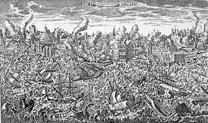
Why is the water black in a tsunami?
The earthquake and the tsunami is a natural phenomenon. BUT the black water is manmade! The black colour is putrefying sewage that accumulates on the ocean floors off the coast line of the continents where humans inhabit. … The black mud spreads to cover the beds of oceans, lakes, rivers and manmade channels.
What are the 4 stages of a tsunami?
Answer 1: A tsunami has four general stages: initiation, split, amplification, and run-up. During initiation, a large set of ocean waves are caused by any large and sudden disturbance of the sea surface, most commonly earthquakes but sometimes also underwater landslides.
What are the three types of tsunami?
Tsunami — Information Page
- Distant tsunami: Are generated from a long way away, such as from across the Pacific in Chile. …
- Regional tsunami: Are generated between one and three hours travel time away from their destination. …
- Local tsunami: Are generated very close to New Zealand.
What are characteristics of tsunami?
Tsunamis are characterized as shallow-water waves. Shallow-water waves are different from wind-generated waves, the waves many of us have observed at the beach.
How tall was the tsunami that killed the dinosaurs?
Now, scientist say they have found evidence of the resulting giant tsunami that swamped much of the Earth. In a study published in the journal Earth & Planetary Science Letters, researchers report how they discovered 52-foot-tall “megaripples” nearly a mile below the surface of what is now central Louisiana.
Which was the first tsunami?
There is geological evidence that large tsunamis have occurred thousands of years ago. In terms of the earliest tsunami in the historical record, a volcano erupted on Santorini Island, Greece and created a large tsunami. The years I’ve found for this event are 1628 BC and 1410 BC.
Has the US ever had a tsunami?
Large tsunamis have occurred in the United States and will undoubtedly occur again. … The tsunami generated by the 1964 magnitude 9.2 earthquake in the Gulf of Alaska (Prince William Sound) caused damage and loss of life across the Pacific, including Alaska, Hawaii, California, Oregon, and Washington.
Author:
Sara Rhodes
Date Of Creation:
10 February 2021
Update Date:
12 April 2023
Content
- What is Tsunami:
- Causes of the tsunami
- Aftermath of the tsunami
- Types of tsunami
- Tsunami and earthquake
What is Tsunami:
Tsunami, also known as a tidal wave, is a large wave that forms due to a volcanic explosion or an earthquake and moves at high speed across the surface of the sea. Tsunamis have enormous destructive power and gain strength when they reach the Coastal Region, forming waves more than 30 meters high.
The word tsunami is of Japanese origin, tsu means «port» and namis it expresses “waves”, therefore, waves from the port, tsunamis not necessarily happen in the port but can be anywhere on the coast, especially in the Pacific and Indian Oceans, as well as in the Mediterranean Sea.
Despite how difficult it is to predict when a tsunami may occur, some countries with higher incidences and risks of suffering these phenomena are: Chile, the United States, Japan, Mexico, Ecuador, they have an alert center although it is not always possible to have the Certainty when it will happen does allow us to calculate the epicenter of a large underwater earthquake and the time it may take for a tsunami to arrive. To facilitate prevention, it is possible to use underwater sensors, radio telemetry, satellite, among other means to try to measure the behavior of waves and sizes.
See also Tectonic plates.
Generally, the waves do not affect a single place, they move according to the sea currents, such as: the earthquake in Chile in 1960, it produced a tsunami that killed approximately 5000 people and 14 hours later it reached Hawaii where it killed more people and 9 hours later it arrived in Japan causing more deaths. Also, in 2004 in Indonesia, 11 countries suffered the ravages of the tsunami, such as: India, Indonesia, Thailand, Sri Lanka, among others.
See also earthquake or earthquake.
There are films and documentaries where he narrates and demonstrates the terrible consequences of a tsunami, as it happens in the film of the impossible, directed by J. A. Bayona, based on the true story of the 2004 Indian tsunami.
In English, the word tsunami is translated in the same way tsunami.
Causes of the tsunami
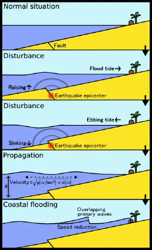
Tsunamis can be caused by underground landslides or volcanic eruptions. The vast majority of tsunamis occur by earthquakes of great magnitude under the water surface, with hypocenter at the depth point and, produce the abrupt vertical movement of the seabed, so that the ocean water is pushed out of its balance normal and when it tries to regain its balance it generates waves. Tsunami waves travel along the ocean at about 805 km per hour and, in the high seas, they are practically imperceptible but when they approach the land, they begin to grow in height and energy, destroying everything around them.
Normally, before the arrival of the tsunami, the sea recedes and until the main wave arrives it can take 5 to 10 minutes, as well as hours for the tsunami to reach land. Also, before the tsunami, as a warning to society, microquakes, low tides, high tides can occur until the sea is completely withdrawn and, only the great wave with the capacity to destroy everything that appears in its path is expected.
Aftermath of the tsunami
- They devastate entire cities.
- Floods of extensive coastal territories.
- They destroy the seabed.
- Lowland vegetation can be destroyed to a considerable extent, such as mangroves and grasses.
- They can cause the extinction of certain rare animals, such as sea turtles.
Types of tsunami
- Slight, the waves are not higher than one meter in height caused by an earthquake considered minor.
- Moderate, of magnitude III, the waves are greater than a meter and a half in height caused by strong tremors greater than 7 degrees.
- Destructive or strong, magnitude IV, they generate waves 10-15 meters high, caused by an order of 8.5 degrees on the Richter scale.
Tsunami and earthquake
The earthquake is the shaking or shaking of the earth’s crust, caused by internal displacements, which is transmitted over great distances in the form of waves. The earthquake is a natural phenomenon characterized by a strong earthquake in the earth caused by collisions of tectonic plates, geological faults or volcanic activity. Tsunamis are caused by underwater earthquakes that cause movements of sea water, as mentioned above.
It is noteworthy that not all earthquakes generate tidal waves, only those of considerable magnitude that occur under the seabed and are capable of deforming it.
The phenomenon we call tsunami is a series of large waves of extremely long wavelength and period usually generated by a violent, impulsive undersea disturbance or activity near the coast or in the ocean. When a sudden displacement of a large volume of water occurs, or if the sea floor is suddenly raised or dropped by an earthquake, big tsunami waves can be formed. The waves travel out of the area of origin and can be extremely dangerous and damaging when they reach the shore.
The word tsunami (pronounced tsoo-nah’-mee) is composed of the Japanese words «tsu» (which means harbor) and «nami» (which means «wave»). Often the term, «seismic or tidal sea wave» is used to describe the same phenomenon, however the terms are misleading, because tsunami waves can be generated by other, non seismic disturbances such as volcanic eruptions or underwater landslides, and have physical characteristics different of tidal waves. The tsunami waves are completely unrelated to the astronomical tides — which are caused by the extraterrestrial, gravitational influences of the moon, sun, and the planets. Thus, the Japanese word «tsunami», meaning «harbor wave» is the correct, official and all-inclusive term. It has been internationally adopted because it covers all forms of impulsive wave generation.
Tsunami waves often look like walls of water and can attack the shoreline and be dangerous for hours, with waves coming every 5 to 60 minutes. The first wave may not be the largest, and often it is the 2nd, 3rd, 4th or even later waves that are the biggest. After one wave inundates, or floods inland, it recedes seaward often as far as a person can see so the seafloor is exposed. The next wave then rushes ashore within minutes and carries with it many floating debris that were destroyed by previous waves. When waves enter harbors, very strong and dangerous water currents are generated that can easily break ship moorings, and bores that travel far inland can be formed when tsunamis enter rivers or other waterway channels.
1983 Japan Sea Tsunami 
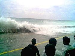
The tsunami that struck Malé in the Maldives on December 26, 2004.
A tsunami (IPA: /(t)sʊˈnɑːmi/) is a series of waves created when a body of water, such as an ocean, is rapidly displaced. Earthquakes, mass movements above or below water, volcanic eruptions and other underwater explosions, landslides, large meteorite impacts, and nuclear weapons testing at sea all have the potential to generate a tsunami. A tsunami can have a range of effects, from unnoticeable to devastating.
A tsunami has a much smaller amplitude (wave height) offshore, and a very long wavelength (often hundreds of kilometers long). Consequently, they generally pass unnoticed at sea, forming only a passing «hump» in the ocean.
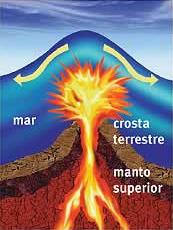
Volcanic eruptions inject tons of wash in the oceanic soil, generating devastating waves
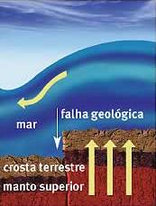
Submarine earthquakes dislocate the oceanic crust, pushing water upwards.
Tsunami have been historically referred to as tidal waves because, as they approach land, they take on the characteristics of a violent, onrushing tide, rather than the sort of cresting waves formed by wind action on the ocean. Given that they are not actually related to tides, the term is considered misleading and its usage is discouraged by oceanographers.[1]
Etymology
The term tsunami comes from the Japanese words (津波、つなみ) meaning harbor («tsu,» 津) and wave («nami,» 波). [a. Jap. tsunami, tunami, f. tsu harbor + nami waves. — Oxford English Dictionary]. For the plural, one can either follow ordinary English practice and add an s, or use an invariable plural as in Japanese. The term was created by fishermen who returned to port to find the area surrounding their harbor devastated, although they had not been aware of any wave in the open water. Tsunami are common throughout Japanese history; approximately 195 events in Japan have been recorded.
Causes
A tsunami can be generated when the plate boundaries abruptly deform and vertically displace the overlying water. Such large vertical movements of the Earth’s crust can occur at plate boundaries. Subduction earthquakes are particularly effective in generating tsunami. Also, one tsunami in the 1940s in Hilo, Hawaii, was actually caused by an earthquake on one of the Aleutian Islands in Alaska. That earthquake was 7.8 on the Richter Scale.
Tsunami are formed as the displaced water mass moves under the influence of gravity and radiates across the ocean like ripples on a pond.
In the 1950s, it was discovered that larger tsunami than previously believed possible could be caused by landslides, explosive volcanic action, and impact events when they contact water. These phenomena rapidly displace large volumes of water, as energy from falling debris or expansion is transferred to the water into which the debris falls. Tsunami caused by these mechanisms, unlike the ocean-wide tsunami caused by some earthquakes, generally dissipate quickly and rarely affect coastlines distant from the source due to the small area of sea affected. These events can give rise to much larger local shock waves (solitons), such as the landslide at the head of Lituya Bay which produced a water wave estimated at 50 – 150 m and reached 524 m up local mountains. However, an extremely large landslide could generate a “megatsunami” that might have ocean-wide impacts.
The geological record tells us that there have been massive tsunami in Earth’s past.
Signs of an approaching tsunami
There is often no advance warning of an approaching tsunami. However, since earthquakes are often a cause of tsunami, an earthquake felt near a body of water may be considered an indication that a tsunami will shortly follow.
When the first part of a tsunami to reach land is a trough rather than a crest of the wave, the water along the shoreline may recede dramatically, exposing areas that are normally always submerged. This can serve as an advance warning of the approaching crest of the tsunami, although the warning arrives only a very short time before the crest, which typically arrives seconds to minutes later.[2] In the 2004 tsunami that occurred in the Indian Ocean, the sea receding was not reported on the African coast or any other western coasts it hit, when the tsunami approached from the east.
Tsunami occur most frequently in the Pacific Ocean, but are a global phenomenon; they are possible wherever large bodies of water are found, including inland lakes, where they can be caused by landslides. Very small tsunami, non-destructive and undetectable without specialized equipment, occur frequently as a result of minor earthquakes and other events.
Warnings and prevention
A tsunami can also be known to come when the water leaves an ocean or large body of water, and then the water in it causes a large series of waves to approach land.
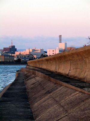
Tsunami wall at Tsu, Japan
Tsunami cannot be prevented or precisely predicted, but there are some warning signs of an impending tsunami, and there are many systems being developed and in use to reduce the damage from tsunami.
In instances where the leading edge of the tsunami wave is its trough, the sea will recede from the coast half of the wave’s period before the wave’s arrival. If the slope is shallow, this recession can exceed many hundreds of meters. People unaware of the danger may remain at the shore due to curiosity, or for collecting shellfish from the exposed seabed.
Regions with a high risk of tsunami may use tsunami warning systems to detect tsunami and warn the general population before the wave reaches land. In some communities on the west coast of the United States, which is prone to Pacific Ocean tsunami, warning signs advise people where to run in the event of an incoming tsunami. Computer models can roughly predict tsunami arrival and impact based on information about the event that triggered it and the shape of the seafloor (bathymetry) and coastal land (topography).[3]
One of the early warnings comes from nearby animals. Many animals sense danger and flee to higher ground before the water arrives. The Lisbon quake is the first documented case of such a phenomenon in Europe. The phenomenon was also noted in Sri Lanka in the 2004 Indian Ocean earthquake.[4] Some scientists speculate that animals may have an ability to sense subsonic Rayleigh waves from an earthquake minutes or hours before a tsunami strikes shore[5]). More likely, though, is that the certain large animals (e.g., elephants) heard the sounds of the tsunami as it approached the coast. The elephants’ reactions were to go in the direction opposite of the noise, and thus go inland. Humans, on the other hand, head down to the shore to investigate.
While it is not possible to prevent tsunami, in some particularly tsunami-prone countries some measures have been taken to reduce the damage caused on shore. Japan has implemented an extensive programme of building tsunami walls of up to 4.5 m (13.5 ft) high in front of populated coastal areas. Other localities have built floodgates and channels to redirect the water from incoming tsunami. However, their effectiveness has been questioned, as tsunami are often higher than the barriers. For instance, the tsunami which struck the island of Hokkaidō on July 12, 1993 created waves as much as 30 m (100 ft) tall — as high as a ten-story building. The port town of Aonae was completely surrounded by a tsunami wall, but the waves washed right over the wall and destroyed all the wood-framed structures in the area. The wall may have succeeded in slowing down and moderating the height of the tsunami, but it did not prevent major destruction and loss of life.
The effects of a tsunami can be mitigated by natural factors such as tree cover on the shoreline. Some locations in the path of the 2004 Indian Ocean tsunami escaped almost unscathed as a result of the tsunami’s energy being sapped by a belt of trees such as coconut palms and mangroves. In one striking example, the village of Naluvedapathy in India’s Tamil Nadu region suffered minimal damage and few deaths as the wave broke up on a forest of 80,244 trees planted along the shoreline in 2002 in a bid to enter the Guinness Book of Records.[6] Environmentalists have suggested tree planting along stretches of seacoast which are prone to tsunami risks. While it would take some years for the trees to grow to a useful size, such plantations could offer a much cheaper and longer-lasting means of tsunami mitigation than the costly and environmentally destructive method of erecting artificial barriers.
Historic Tsunami
Tsunami occur most frequently in the Pacific Ocean, but are a global phenomenon; they are possible wherever large bodies of water are found, including inland lakes, where they can be caused by landslides. Very small tsunami, non-destructive and undetectable without specialized equipment, occur frequently as a result of minor earthquakes and other events.
Japan is the nation with the most recorded tsunami in the world. The earliest recorded disaster was the tsunami associated with the 684 C.E. Hakuho Earthquake. The number of tsunami in Japan totals 195 over a 1,313 year period, averaging one event every 6.7 years, the highest rate of occurrence in the world. These waves have hit with such violent fury that entire towns have been destroyed.
The destruction of much of Alexandria on August 21, 365 C.E. is presently attributed to a tsunami. In the witness account collected soon afterward by Ammianus Marcellinus (in his «Roman history,» book 26) all the typical features of a tsunami can be recognized: “The sea was driven back, and its waters flowed away to such an extent that the deep sea bed was laid bare, and many kinds of sea creatures could be seen. (…) Many ships were therefore stranded as if on dry land, and many people wandered freely (…) gathering fish and similar creatures (…) huge masses of water flowed back when least expected, and now overwhelmed and killed many thousands of people (…) Some great ships were hurled by the fury of the waves on to roof tops (as happened at Alexandria) and others were thrown up to two miles from the shore”[7].
In 1607, Bristol Channel floods resulted in the drowning of an estimated 2000 or more people, with houses and villages swept away, farmland inundated and livestock destroyed, wrecking the local economy along the coasts of the Bristol Channel, UK. Some churches have plaques up to 8ft above sea level to show how high the waters rose.
The cause of the flood is not yet proven, but a research paper published in the journal Archaeology in the Severn Estuary in 2002 following investigations by Professor Simon Haslett, from Bath Spa University, and Australian geologist Ted Bryant, from the University of Wollongong, proposed that the flooding was caused by a tsunami.
The British Geological Survey has suggested an earthquake on a known unstable fault off the coast of Ireland causing the vertical displacement of the sea floor as the possible cause.
684 Kii Channel Earthquake, Japan
The first recorded tsunami ever was in Japan on October 14, 684. It occurred off the shore of the Kii Peninsula. It has been estimated to be a magnitude 8.3. It was followed by a huge tsunami, but no estimates on how many deaths.
1096/1099 Quakes, Japan
Suruga Bay and Izu Peninsula experienced great tsunamis in 1096, followed by Shikoku and Kii Peninsula great tsunami of 1099. The magnitudes of both are estimated to have been in the 8 range.
1700 — Vancouver Island, Canada
January 26, 1700 — The Cascadia Earthquake, one of the largest earthquakes on record (estimated MW 9 magnitude), ruptured the Cascadia subduction zone (CSZ) offshore from Vancouver Island to northern California, and caused massive tsunami across the Pacific Northwest logged in Japan and oral traditions of the Native Americans. Brian F. Atwater, Musumi-Rokkaku Satoko, Satake Kenji, Tsuji Yoshinobu, Ueda Kazue, and David K. Yamaguch prepared a «scientific detective story» investigating this tsunami entitled The Orphan Tsunami of 1700—Japanese Clues to a Parent Earthquake in North America.[8]
1703 Kanto Quake, Japan
In Nov 23, 1703, an offshore earthquake produced a massive tsunami, hitting the southern shores of Kanagawa prefecture. Mount Fuji erupted, spewing heavy ash over Edo (now Tokyo). It was estimated to be magnitude 8.1, and 5,200 people died from the combined quake and tsunami, later more died from the ashfall crushing roofs.
1755 — Lisbon, Portugal
Tens of thousands of Portuguese who survived the Great Lisbon Earthquake on November 1 were killed by a tsunami which followed a half hour later. Many townspeople fled to the waterfront, believing the area safe from fires and from falling debris from aftershocks. Before the great wall of water hit the harbor, waters retreated, revealing lost cargo and forgotten shipwrecks. These people did not know that a Tsunami is a succession of waves, rather than just a single one.
The earthquake, tsunami, and many forest fires killed between 60,000 and 100,000 of Lisbon’s pre-quake population of 275,000. Historical records of explorations by Vasco da Gama and other early navigators were lost, and countless buildings were destroyed (including most examples of Portugal’s Manueline architecture). Europeans of the eighteenth century struggled to understand the disaster within religious and rational belief systems. Philosophers of the Enlightenment, notably Voltaire, wrote about the event. The philosophical concept of the sublime, as described by philosopher Immanuel Kant in the Observations on the Feeling of the Beautiful and Sublime, took inspiration in part from attempts to comprehend the enormity of the Lisbon quake and tsunami.
The tsunami took just over four hours to travel over 1000 miles to Cornwall in the United Kingdom. An account by Arnold Boscowitz (a century later) claimed «great loss of life.»
1771 — Yaeyama Islands, Okinawa, Japan
An undersea earthquake of estimated magnitude 7.4 occurred near Yaeyama Islands in Okinawa, Japan on April 4, 1771 at about 8 A.M. The earthquake is not believed to have directly resulted in any deaths, but a resulting tsunami is thought to have killed about 12,000 people, (9313 on the Yaeyama Islands and 2548 on Miyako Islands according to one source. Estimates of the highest seawater runup on Ishigaki Island, range between 30 meters and 85.4 meters. The tsunami put an abrupt stop to population growth on the islands, and was followed by malaria epidemics and crop failures which decreased the population further. It was to be another 148 years before population returned to its pre-tsunami level.
1792 — Tsunami in Kyūshū, Japan
Tsunamis were the main cause of death for Japan’s worst-ever volcanic disaster, due to an eruption of Mount Unzen in Nagasaki Prefecture, Kyūshū, Japan. It began towards the end of 1791 as a series of earthquakes on the western flank of Mount Unzen which gradually moved towards Fugen-daké, one of Mount Unzen’s peaks. In February 1792, Fugen-daké started to erupt, triggering a lava flow which continued for two months. Meanwhile, the earthquakes continued, shifting nearer to the city of Shimabara. On the night of May 21, two large earthquakes were followed by a collapse of the eastern flank of Mount Unzen’s Mayuyama dome, causing an avalanche which swept through Shimabara and into Ariake Bay, triggering a tsunami. It is not known to this day whether the collapse occurred as a result of an eruption of the dome or as a result of the earthquakes. The tsunami struck Higo Province on the other side of Ariake Bay before bouncing back and hitting Shimabara again. Out of an estimated total of 15,000 fatalities, around 5,000 is thought to have been killed by the landslide, around 5000 by the tsunami across the bay in Higo Province, and a further 5000 by the tsunami returning to strike Shimabara.
1854 Ansei Nankai Quakes in South Coast of Japan
The Great Ansei Nankai quake, was actually set of three quakes, two magnitude 8.4 quakes and a 7.4 quake all in three days. The first on Nov. 4, 1854 near what is today Aichi Prefecture and Shizuoka Prefecture with tsunami, followed by another 8.4 the next day in Wakayama Prefecture, which created a 10-meter high tsunami that hit the south coast of Japan. The third was a 7.4 quake on Nov. 7, 1854 in Ehime Prefecture and Oita Prefecture. The result was 80,000-100,000 deaths.[9]
The following year, the 1854 Edo Ansei Quake hit (Tokyo region), killing 4,500 to 10,000 people. Popular stories of the time blamed the quakes and tsunamis on giant catfish thrashing about.
1868 — Hawaiian Islands local tsunami generated by earthquake
On April 2, 1868, a local earthquake with a magnitude estimated between 7.25 and 7.75 rocked the southeast coast of the Big Island of Hawai’i. It triggered a landslide on the slopes of the Mauna Loa volcano, five miles north of Pahala, killing 31 people. A tsunami then claimed 46 additional lives. The villages of Punaluu, Ninole, Kawaa, Honuapo, and Keauhou Landing were severely damaged. According to one account, the tsunami «rolled in over the tops of the coconut trees, probably 60 feet high …. inland a distance of a quarter of a mile in some places, taking out to sea when it returned, houses, men, women, and almost everything movable.» This was reported in the 1988 edition of Walter C. Dudley’s book Tsunami! (ISBN 0824811259).
1883 — Krakatoa explosive eruption
The island volcano of Krakatoa in Indonesia exploded with devastating fury on August 26-27, 1883, blowing its underground magma chamber partly empty so that much overlying land and seabed collapsed into it. A series of large tsunami waves was generated from the collapse, some reaching a height of over 40 meters above sea level. Tsunami waves were observed throughout the Indian Ocean, the Pacific Ocean, the American West Coast, South America, and even as far away as the English Channel. On the facing coasts of Java and Sumatra the sea flood went many miles inland and caused such vast loss of life that one area was never resettled but went back to the jungle and is now the Ujung Kulon nature reserve.
1896 — Sanriku coast, Japan
On 15 June, 1896, at around 19:32 local time, a magnitude 8.5 undersea earthquake off the Sanriku coast of northeastern Honshū, Japan, triggered tsunami waves which struck the coast about half an hour later. Although the earthquake itself is not thought to have resulted in any fatalities, the waves, the highest recorded measurement of which reaching 38.2 meters, killed approximately 20,000 people. In 2005 the same general area was hit by the 2005 Sanriku Japan Earthquake, but with no tsunami.
1917 — Halifax Explosion and tsunami
The Halifax Explosion occurred on Thursday, December 6, 1917 at 9:04:35 A.M. local time in Halifax, Nova Scotia in Canada, when the French munitions ship Mont-Blanc, bound for World War I France, collided with the Norwegian ship Imo, chartered to carry Belgian relief supplies. In the aftermath of the collision, Mont-Blanc caught fire and exploded. The explosion caused a tsunami, and a pressure wave of air.
1923 — The Great Kanto Earthquake, Japan
The Great Kanto Earthquake, which occurred in Eastern Japan on September 1, 1923, and devastated Tokyo, Yokohama and the surrounding areas, caused tsunami which struck the Shonan coast, Boso Peninsula, Izu Islands and the east coast of Izu Peninsula, within minutes in some cases. In Atami, waves reaching 12 meters were recorded. Examples of tsunami damage include about 100 people killed along Yui-ga-hama beach in Kamakura and an estimated 50 people on the Enoshima causeway. However, tsunami only accounted for a small proportion of the final death toll of over 100,000, most of whom were killed in fire.
1929 — Newfoundland tsunami
On November 18, 1929, an earthquake of magnitude 7.2 occurred beneath the Laurentian Slope on the Grand Banks. The quake was felt throughout the Atlantic Provinces of Canada and as far west as Ottawa and as far south as Claymont, Delaware. The resulting tsunami measured over 7 meters in height and took about 2½ hours to reach the Burin Peninsula on the south coast of Newfoundland, where 29 people lost their lives in various communities. It also snapped telegraph lines laid under the Atlantic.
1933 — Sanriku coast, Japan
On March 3, 1933, the Sanriku coast of northeastern Honshū, Japan which had already suffered a devastating tsunami in 1896 (see above) was again stuck by tsunami waves as a result of an offshore magnitude 8.1 earthquake. The quake destroyed about 5,000 homes and killed 3,068 people, the vast majority as a result of tsunami waves. Especially hard hit was the coastal village of Taro (now part of Miyako city) in Iwate Prefecture, which lost 42 percent of its total population and 98% of its buildings. Taro is now protected by an enormous tsunami wall, currently 10 meters in height and over 2 kilometers long. The original wall, constructed in 1958, saved Taro from yet another destruction from the 1960 Chilean tsunami (see below).
1944 — Tonankai Earthquake, Japan
A magnitude 8.0 earthquake on 7 December, 1944, about 20 km off the Shima Peninsula in Japan, which struck the Pacific coast of central Japan, mainly Mie, Aichi, and Shizuoka Prefectures. News of the event was downplayed by the authorities in order to protect wartime morale, and as a result the full extent of the damage is not known, but the quake is estimated to have killed 1223 people, the tsunami being the leading cause of the fatalities.
1946 — Nankai Earthquake, Japan
The Nankai earthquake, a periodic earthquake of around magnitude 8.0 which occurs off the southern coast of Kii Peninsula and Shikoku, Japan every 100 to 150 years, last struck on 21 December, 1946. The resulting tsunami hit the Pacific coast of western Japan. Particularly hard hit were the coastal towns of Kushimoto and Kainan on the Kii Peninsula. The quake led to more than 1400 deaths, tsunami being the leading cause .
1946 — Pacific tsunami
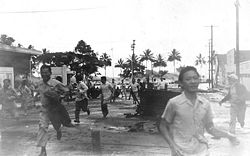
Residents run from an approaching tsunami in Hilo, Hawai’i
The April 1 Aleutian Island earthquake tsunami that killed 159 people on Hawai’i and five in Alaska (the lighthouse keepers at the Scotch Cap Light in the Aleutians) resulted in the creation of a tsunami warning system known as the Pacific Tsunami Warning System (specifically the PTWC), established in 1949 for Pacific Ocean area countries. The tsunami is known as the April Fools Day Tsunami in Hawai’i due to people thinking the warnings were an April Fools prank.
1958 — Lituya Bay megatsunami
On July 9, 1958, an earthquake with a magnitude of 8.3 on the Richter scale rocked a small inlet in Alaska called Lituya Bay. It then caused part of a mountain at the back of the bay to collapse, causing a monstrous tsunami (an iminami) to fly headlong through the bay. At a mountain at the mouth of the bay, the run was measured to be 524 m (about 1742 ft) making it the largest wave in recorded history. It swept up three boats; one managed to ride the wave, but the other two were swept into the Pacific Ocean, where they were completely destroyed and four people aboard them were killed.
1960 — Chilean tsunami
The magnitude 9.5 Great Chilean Earthquake of May 22, 1960 is the strongest earthquake ever recorded. Its epicenter, off the coast of South Central Chile, generated one of the most destructive tsunami of the 20th Century.
It spread across the entire Pacific Ocean, with waves measuring up to 25 meters high. The first tsunami arrived at Hilo approximately 14.8 hrs after it originated off the coast of South Central Chile. The highest wave at Hilo Bay was measured at around 10.7 m (35 ft). 61 lives were lost allegedly due to people’s failure to heed warning sirens.
Almost 22 hours after the quake, the waves hit the ill-fated Sanriku coast of Japan, reaching up to 3 m above high tide, and killed 142 people. Up to 6,000 people died in total worldwide due to the earthquake and tsunami.[10]
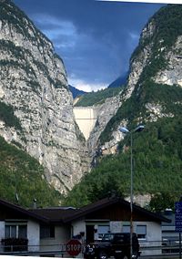
The Vajont Dam as seen from Longarone today, showing approximately the top 60-70 metres of concrete. The 200-250 metre wall of water (megatsunami) that over-topped the dam would have obscured virtually all of the sky in this picture.
1963 — Vajont Dam Megatsunami
The Vajont Dam was completed in 1961 under Monte Toc, 100 km north of Venice, Italy. At 262 metres, it was one of the highest dams in the world. On October 9, 1963 an enormous landslide of about 260 million cubic metres of forest, earth, and rock, fell into the reservoir at up to 110 km per hour (68 mph). The resulting displacement of water caused 50 million cubic metres of water to overtop the dam in a 250-metre high wave. The flooding destroyed the villages of Longarone, Pirago, Rivalta, Villanova and Faè, killing 1,450 people. Almost 2,000 people (some sources report 1,909) perished in total.
1964 — Niigata Earthquake
The 1964 Niigata earthquake in Japan killed 28 people, and liquefacted whole apartment buildings. A subsequent tsunami destroyed the port of Niigata city.
1964 — Good Friday tsunami
After the magnitude 8.6 «Good Friday Earthquake» tsunami struck Alaska, British Columbia, California, and coastal Pacific Northwest towns, killing 121 people. The waves caused by the Tsunami were up to 23 m tall, and killed 11 people as far away as Crescent City, California.This happened on March 27, 1964
1976 — Moro Gulf tsunami
On August 16, 1976 at 12:11 A.M., a devastating earthquake of 7.9 hit the island of Mindanao, Philippines. It created a tsunami that devastated more than 700 km of coastline bordering Moro Gulf in the North Celebes Sea. An estimated number of victims for this tragedy left 5,000 dead, 2,200 missing or presumed dead, more than 9,500 injured and a total of 93,500 people were left homeless. It devastated the cities of Cotabato, Pagadian, and Zamboanga, and the and provinces of Basilan, Lanao del Norte, Lanao del Sur, Maguindanao, Sultan Kudarat, Sulu, and Zamboanga del Sur.
1979 — Tumaco tsunami
A magnitude 7.9 earthquake occurred on December 12, 1979 at 7:59:4.3 UTC along the Pacific coast of Colombia and Ecuador. The earthquake and the resulting tsunami caused the destruction of at least six fishing villages and the death of hundreds of people in the Colombian province of Nariño. The earthquake was felt in Bogotá, Cali, Popayán, Buenaventura, and several other cities and towns in Colombia and in Guayaquil, Esmeraldas, Quito, and other parts of Ecuador. When the Tumaco Tsunami hit the coast, it caused huge destruction in the city of Tumaco, as well as in the small towns of El Charco, San Juan, Mosquera, and Salahonda on the Pacific coast of Colombia. The total number of victims of this tragedy was 259 dead, 798 wounded and 95 missing or presumed dead.
1983 — Sea of Japan tsunami
On May 26, 1983 at 11:59:57 local time, a magnitude-7.7 earthquake occurred in the Sea of Japan, about 100 km west of the coast of Noshiro in Akita Prefecture, Japan. Out of the 107 fatalities, all but four were killed by the resulting tsunami, which struck communities along the coast, especially Aomori and Akita Prefectures and the east coast of Noto Peninsula. Footage of the tsunami hitting the fishing harbor of Wajima on Noto Peninsula was broadcast on TV. The waves exceeded 10 meters in some areas. Three of the fatalities were along the east coast of South Korea (whether North Korea was affected is not known).
1993 — Okushiri, Hokkaido tsunami
A devastating tsunami wave occurred along the coasts of Hokkaidō in Japan as a result of a magnitude 7.8 earthquake, 80 miles offshore, on July 12, 1993.
Within minutes, the Japan Meteorological Agency issued a tsunami warning that was broadcast on NHK in English and Japanese. However, it was too late for Okushiri, a small island near the epicenter, which was struck with extremely big waves, some reaching 30 meters, within two to five minutes of the quake. Aonae, a village on a low-lying peninsula at the southern tip of the island, was devastated over the course of the following hour by 13 waves of over two meters’ height arriving from multiple directions, including waves that had bounced back off Hokkaidō—despite being surrounded by tsunami barriers. Of 250 people killed as a result of the quake, 197 were victims of the series of tsunamis that hit Okushiri; the waves also caused deaths on the coast of Hokkaidō. While many residents, remembering the 1983 tsunami (see above), survived by quickly evacuating on foot to higher ground, it is thought that many others underestimated how soon the waves would arrive (the 1983 tsunami took 17 minutes to hit Okushiri) and were killed as they attempted to evacuate by car along the village’s narrow lanes. The highest wave of the tsunami was a staggering 31 meters (102 feet) high.
1998 — Papua New Guinea
On July 17, 1998, a Papua New Guinea tsunami killed approximately 2200 people [11]. A 7.1 magnitude earthquake 24 km offshore was followed within 11 minutes by a tsunami about 12 m tall. While the magnitude of the quake was not large enough to create these waves directly, it is believed the earthquake generated an undersea landslide, which in turn caused the tsunami. The villages of Arop and Warapu were destroyed.
2004 — Indian Ocean tsunami
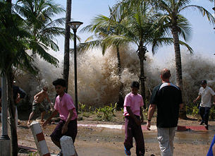
The 2004 Indian Ocean earthquake; Tsunami strikes Ao Nang, Thailand.
The 2004 Indian Ocean earthquake, which had a magnitude of 9.0 to 9.3,[12] triggered a series of lethal tsunami on December 26, 2004, that killed approximately 300,000 people (including 168,000 in Indonesia alone), making it the deadliest tsunami as well as one of the deadliest natural disasters in recorded history. It also had the second-largest earthquake in recorded history. The initial surge was measured at a height of approximately 33 meters (108 feet), making it the largest earthquake-generated tsunami in recorded history. The tsunami killed people over an area ranging from the immediate vicinity of the quake in Indonesia, Thailand, and the north-western coast of Malaysia, to thousands of kilometres away in Bangladesh, India, Sri Lanka, the Maldives, and even as far away as Somalia, Kenya, and Tanzania in eastern Africa. This is an example of a teletsunami which can travel vast distances across the open ocean, in this case, it is an inter-continental tsunami. Tsunami waves 2.6 meters tall were reported even in places such as Mexico, nearly 13,000 km away from the epicenter. The energies for these waves travel along fault lines and becoming concentrated therefore traveling further.
Unlike in the Pacific Ocean, there was no organized alert service covering the Indian Ocean. This was in part due to the absence of major tsunami events since 1883 (the Krakatoa eruption, which killed 36,000 people). In light of the 2004 Indian Ocean tsunami, UNESCO and other world bodies have called for an international tsunami monitoring system.
2006 — South of Java Island tsunami
A 7.7 magnitude earthquake rocked the Indian Ocean seabed on July 17,2006, 200 km south of Pangandaran, a beautiful beach famous to surfers for its perfect waves. This earthquake triggered tsunami whose heights varied from 2 meters at Cilacap to 6 meters at Cimerak beach, where it swept away and flattened buildings as far as 400 meters away from the coastline. More than 800 people were reported missing or dead.
2006 — Kuril Islands tsunami
On November 15, 2006, an 8.1 magnitude quake struck an area claimed by both Russia and Japan, but the waves near Japan did not swell higher than 23 inches. There were no immediate reports of casualties or damage. Six hours later, tsunami waves up to nearly 5 feet high caused by the quake crashed into Crescent City, California and Santa Cruz, California causing considerable damage.
2007 — Solomon Islands tsunami
On April 2, 2007, a powerful magnitude 8.1 (initially 7.6) earthquake hit the East Pacific region about 25 miles (40 km) northwest of the Solomon Islands at 7:39 A.M., resulting in a tsunami that was up to 17 feet (5 meters) tall. The wave, which struck the coast of Solomon Islands (mainly Gizo), triggered region-wide tsunami warnings and watches extending from Japan to New Zealand to Hawaii and the eastern seaboard of Australia. So far, at least 39 people are confirmed dead with the toll expected to rise. Dozens more have been injured with entire towns inundated by the sweeping water which traveled 300 meters inland in some places. Simbo, Choiseul and Ranunga islands were also affected. A state of national emergency was declared for the Solomon Islands. On the island of Choiseul, a wall of water reported to be 30 feet high swept almost 400 meters inland destroying everything in its path. Officials estimate that the tsunami displaced more than 5000 residents all over the archipelago.
2007 — Niigata earthquake
On July 16, 2007, a strong earthquake struck northwestern Japan, causing a fire and minor radioactive water leak at one of the world’s most powerful nuclear power plants. At least seven people were killed and hundreds injured. Japan’s Meteorological Agency measured the quake at 6.8 on the richter scale and sending aftershocks of 6.6. The U.S. Geological Survey, which monitors quakes around the world, said the initial quake registered 6.7. A tsunami watch was issued along the Sea of Japan. The predicted height of the tsunami was estimated to be 50 cm (20 inches).[13] That earthquake sparked only a few small tsunamis, growing to be no more than about 20 cm (8 inches) tall.[14] However, the 1964 quake and tsunami north of the current one destroyed the port of the city of Niigata.
Other tsunami in South Asia
| Tsunami in South Asia (Source: Amateur Seismic Centre, India)[15] |
|
|---|---|
| Date | Location |
| 1524 | Near Dabhol, Maharashtra |
| 02 April 1762 | Arakan Coast, Myanmar |
| 16 June 1819 | Rann of Kachchh, Gujarat, India |
| 31 October 1847 | Great Nicobar Island, India |
| 31 December 1881 | Car Nicobar Island, India |
| 26 August 1883 | Krakatoa volcanic eruption |
| 28 November 1945 | Mekran coast, Balochistan |
North American and Caribbean tsunami
- 1690 — Nevis
- 14 November 1840 — Great Swell on the Delaware River
- 18 November 1867 — Virgin Islands
- 17 November 1872 — Maine
- 11 October 1918 — Puerto Rico
- 18 November 1929 — Newfoundland
- 9 January 1926 — Maine
- 4 August 1946 — Dominican Republic
- 18 August 1946 — Dominican Republic
- 27 March 1964 — Crescent City, CA
- 15 November 2006 — Crescent City, CA
Possible tsunami
- 35 million years ago — Chesapeake Bay impact crater, Chesapeake Bay
- 9 June 1913 — Longport, NJ
- 6 August 1923 — Rockaway Park, Queens, NY .
- 8 August 1924 — Coney Island, NY .
- 19 August 1931 — Atlantic City, NJ
- 22 June 1932 — Cuyutlán, Colima, Mexico
- 19 May 1964 — Northeast USA
- 4 July 1992 — Daytona Beach, FL
Source: NOAA National Weather Service Forecast Office, [2]
European tsunami
- 6100 B.C.E. — Storegga Slide, Norway
- October 16, 1979 — 23 people died when the coast of Nice, France, was hit by a tsunami. This may have had a man-made cause: construction at the new Nice airport creating an undersea landslide.[16] [17]
Other historic tsunami
Other tsunami that have occurred include the following:
- ca. 500 B.C.E.: Poompuhar, Tamil Nadu, India, Maldives
- ca. 450 B.C.E.: The Greek historian Thucydides in his book History of the Peloponnesian Wars, speculated about the causes of tsunami. He argued that it could only be explained as a consequence of ocean earthquakes, and could see no other possible causes for the phenomenon.
- 1541: a tsunami struck the earliest European settlement in Brazil, São Vicente. There is no record of deaths or injuries, but the town was almost completely destroyed.
- January 20, 1606/1607: along the coast of the Bristol Channel thousands of people were drowned, houses and villages swept away, farmland was inundated and flocks were destroyed by a flood that might have been a tsunami. While it is quite possible that it was caused by a combination of meteorological extremes and tidal peaks, recent evidence points more strongly towards a tsunami.[18]
See also
- Earthquake
- Ocean
- Tide
- Volcano
Notes
- ↑ Can It Happen Here? USGS. Retrieved August 18, 2007.
- ↑ The Aitape 1998 tsunami: Reconstructing the event from interviews and field mapping. NOAA. Retrieved August 18, 2007.
- ↑ The Tsunami Story. NOAA. Retrieved August 18, 2007.
- ↑ Tsunami: Anatomy of a disaster. BBC News. Retrieved August 18, 2007.
- ↑ Christine Kenneally, 2004, Surviving the Tsunami. Slate. Retrieved August 18, 2007.
- ↑ Tsunami villagers give thanks to trees. BBC News. Retrieved August 18, 2007.
- ↑ Jean-Daniel Stanley and Thomas F. Jorstad. 2005. The 365 C.E. tsunami destruction of Alexandria, Egypt: erosion, deformation of strata and introduction of allochthonous material. GSA. Retrieved August 18, 2007.
- ↑ U.S. Geological Survey
Professional Paper 1707. The Orphan Tsunami of 1700—Japanese Clues to a Parent Earthquake in North America. USGS. Retrieved August 18, 2007. - ↑ 安政南海地震. (Japanese). Retrieved August 18, 2007.
- ↑ Emergency & Disasters Data Base. CRED. Retrieved August 18, 2007.
- ↑ Descriptive Model of the July 17, 1998 Papua New Guinea Tsunami. USGS. Retrieved August 18, 2007.
- ↑ Dec 26, 2004 Magnitude 9.0 Earthquake & Tsunami in the Indian Ocean. NOAA. Retrieved August 18, 2007.
- ↑ Strong quake jolts Japan, tsunami alert issued. Reuters. Retrieved August 18, 2007.
- ↑ Mitch Marconi, 2007. Second Japan Earthquake In Sea Of Japan 6.8 Magnitude, Tsunami Fear. The Post Chronicle. Retrieved August 18, 2007.
- ↑ [1] Tsunamis & Seiches. ASC India.org. Retrieved August 18, 2007.
- ↑ Marine Georesources & Geotechnology. Taylor & Francis Group. Retrieved August 18, 2007.
- ↑ TSUNAMIS ET RAZ DE MAREE HISTORIQUES. (French). Azurseisme. Retrieved August 18, 2007.
- ↑ Was Bristol Channel hit by a tsunami? information from Edward A. Bryant and Simon K. Haslett, «Catastrophic Wave Erosion, Bristol Channel, United Kingson: Impact of Tsunami?» The Journal of Geology 115: 253-269. Eurekalert. Retrieved August 18, 2007.
References
ISBN links support NWE through referral fees
- Dudley, Walter C. & Min Lee. 1988. Tsunami! Honolulu, HI: University of Hawaii Press. ISBN 0824811259.
- Iwan, W.D., ed. 2006. Summary report of the Great Sumatra Earthquakes and Indian Ocean tsunamis of 26 December 2004 and 28 March 2005: Earthquake Engineering Research Institute. Oakland, CA: EERI. ISBN 193288419X
- Kenneally, Christine. 2004). Surviving the Tsunami. Slate.com. Retrieved August 18, 2007.
- Macey, Richard. 2005. «The Big Bang that Triggered A Tragedy,» The Sydney Morning Herald, 11 — quoting Dr Mark Leonard, seismologist at Geoscience Australia.
- Lambourne, Helen. 2005. Tsunami: Anatomy of a disaster. BBC News. Retrieved August 18, 2007.
- Tsunamis: Tsunamis travel fast but not at infinite speed. abelard.org. Retrieved August 18, 2007.
- The NOAA’s page on the 2004 Indian Ocean earthquake and tsunami. NOAA. Retrieved August 18, 2007.
External links
All links retrieved March 27, 2020.
- NOVA: Wave That Shook The World — Site and special report shot within days of the 2004 Indian Ocean tsunami.
- NOAA Tsunami — General description of tsunamis and the United States agency NOAA’s role in Tsunami hazard assessment, preparedness, education, forecasts & warnings, response, and research.
- The International Centre for Geohazards (ICG).
- NOAA Center for Tsunami Research (incorporates the PMEL Tsunami Research Program) (United States).
- USGS: Surviving a tsunami (United States).
- Pacific Tsunami Museum.
- Tsunamis and Earthquakes.
- Tsunami Centers — United States National Weather Service.
- What Causes a Tsunami?.
- Satellite Images of Tsunami Affected Areas High resolution satellite images showing the effects of the 2004 tsunami on the affected areas in Indonesia, Thailand and Nicobar island of India.
- Animations of actual and simulated tsunami events from the NOAA Center for Tsunami Research.
- How do tsunamis differ from other water waves?.
Credits
New World Encyclopedia writers and editors rewrote and completed the Wikipedia article
in accordance with New World Encyclopedia standards. This article abides by terms of the Creative Commons CC-by-sa 3.0 License (CC-by-sa), which may be used and disseminated with proper attribution. Credit is due under the terms of this license that can reference both the New World Encyclopedia contributors and the selfless volunteer contributors of the Wikimedia Foundation. To cite this article click here for a list of acceptable citing formats.The history of earlier contributions by wikipedians is accessible to researchers here:
- Tsunami history
The history of this article since it was imported to New World Encyclopedia:
- History of «Tsunami»
Note: Some restrictions may apply to use of individual images which are separately licensed.