

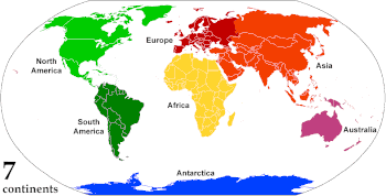
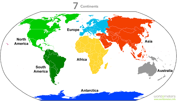
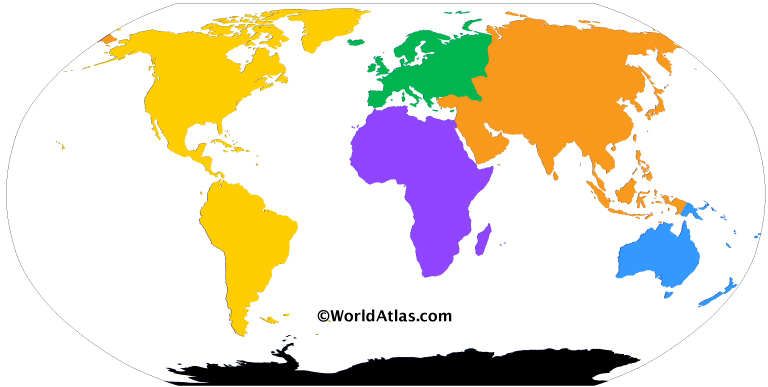
There are seven continents in the world. They are; Asia, Africa, Europe, North America, South America, Antarctica, and Australia & Oceania.
A continent can be defined as a large landmass that comprises the surface of the earth. However, there is a lot of variation in the size of each of the seven continents. The continents also include the neighboring islands.
Among the seven continents, Asia is the largest in the world and covers an area of 16,920,000 square miles, which is roughly 30% of the world’s total land area. The continent comprises a population of 4,436,224,000 inhabitants, which is around 60% of the total population of the world. The continent is also home to the two most populous countries in the world – China and India.
Africa is the second-largest continent in the world and covers an area of 11,730,000 square miles. Africa is also the second most populous continent and had a population of 1,216,130,000 people as of 2016. Africa comprises around 20.4% of the total land area of the earth and is home to 54 fully sovereign recognized states. It also contains nine territories and two de facto independent states that have limited or no recognition.
North America is the third largest continent and covers an area of 9,460,000 square miles. With a population of 579,024,000 people, it is the fourth most populous continent in the world.
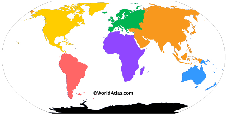
South America is the fourth largest continent in the world and covers an area of 6,890,000 square miles. It is the fifth most populous continent, and as of 2016 had a population of 422,535,000 people. Brazil is the largest country in South America.
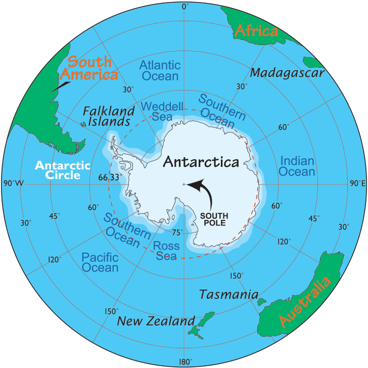
The largely uninhabited Antarctica is the fifth-largest continent in the world. It comprises an area of 5,300,000 square miles. The continent does not have a permanent population, but many countries have permanently manned research stations there. The number of people conducting scientific research in Antarctica varies between 1,000 and 5,000 people. It is the driest, windiest, and coldest continent.
Europe is the sixth largest continent and the third most populous and covers an area of 3,930,000 square miles and had a population of 738,849,000, as of 2016. Russia, Turkey, and Kazakhstan are transcontinental countries with land in both Asia and Europe. The European part of Russia is the largest country in Europe.
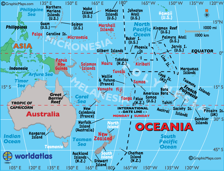
Australia & Oceania are the smallest of the seven continents. It covers an area of 3,478,200 square miles and has a population of 39,901,000 people. New Zealand is considered to be a part of Zealandia, a submerged continent. New Zealand and Australia are both parts of Oceania.
Related Links:
- What is the Hottest Continent?
- Is Asia the Largest Continent?
- Is Egypt in Asia or Africa?
- Is America a Country or a Continent?
- What Countries Comprise Oceania?
- Is Europe a Continent?
Related Map:

Animated, colour-coded map showing the various continents. Depending on the convention and model, some continents may be consolidated or subdivided.
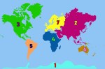
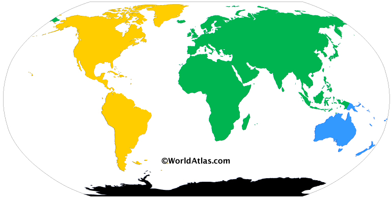
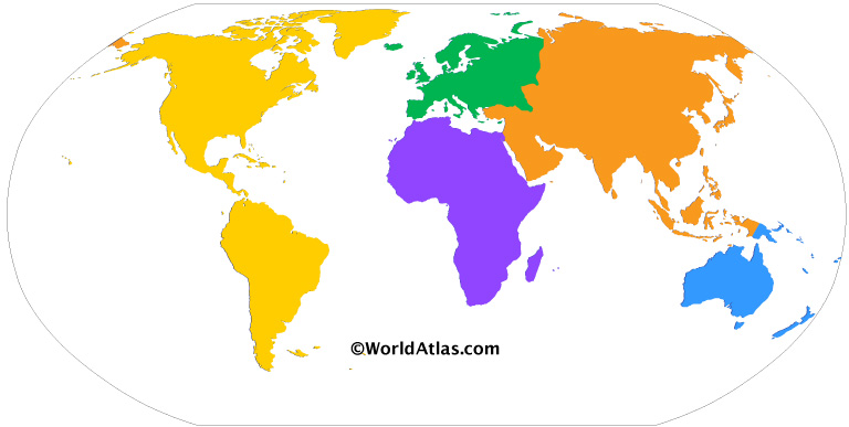
A continent is any of several large geographical regions. Continents are generally identified by convention rather than any strict criteria. A continent could be a single landmass or a part of a very large landmass, as in the case of Asia or Europe. Due to this, the number of continents varies; up to seven or as few as four geographical regions are commonly regarded as continents. Most English-speaking countries recognize seven regions as continents. In order from largest to smallest in area, these seven regions are Asia, Africa, North America, South America, Antarctica, Europe, and Australia.[1] Different variations with fewer continents merge some of these regions, examples of this are merging North America and South America into America, Asia and Europe into Eurasia, and Africa, Asia, and Europe into Afro-Eurasia.
Oceanic islands are frequently grouped with a nearby continent to divide all the world’s land into geographical regions. Under this scheme, most of the island countries and territories in the Pacific Ocean are grouped together with the continent of Australia to form the geographical region Oceania.[2]
In geology, a continent is defined as «one of Earth’s major landmasses, including both dry land and continental shelves».[3] The geological continents correspond to seven large areas of continental crust that are found on the tectonic plates, but exclude small continental fragments such as Madagascar that are generally referred to as microcontinents. Continental crust is only known to exist on Earth.[4]
The idea of continental drift gained recognition in the 20th century. It postulates that the current continents formed from the breaking up of a supercontinent (Pangaea) that formed hundreds of millions of years ago.
Definitions and application
By convention, continents «are understood to be large, continuous, discrete masses of land, ideally separated by expanses of water».[5] In modern schemes with five or more recognized continents, at least one pair of continents is joined by land in some fashion. The criterion «large» leads to arbitrary classification: Greenland, with a surface area of 2,166,086 square kilometres (836,330 sq mi), is only considered the world’s largest island, while Australia, at 7,617,930 square kilometres (2,941,300 sq mi), is deemed the smallest continent.
Earth’s major landmasses all have coasts on a single, continuous World Ocean, which is divided into a number of principal oceanic components by the continents and various geographic criteria.[6][7]
Extent
The most restricted meaning of continent is that of a continuous[8][non-tertiary source needed] area of land or mainland, with the coastline and any land boundaries forming the edge of the continent. In this sense, the term continental Europe (sometimes referred to in Britain as «the Continent») is used to refer to mainland Europe, excluding islands such as Great Britain, Iceland, Ireland, and Malta while the term continent of Australia may refer to the mainland of Australia, excluding New Guinea, Tasmania, and other nearby islands. Similarly, the continental United States refers to «the 49 States (including Alaska but excluding Hawaii) located on the continent of North America, and the District of Columbia.»[9]
From the perspective of geology or physical geography, continent may be extended beyond the confines of continuous dry land to include the shallow, submerged adjacent area (the continental shelf)[10] and the islands on the shelf (continental islands), as they are structurally part of the continent.[11]
From this perspective, the edge of the continental shelf is the true edge of the continent, as shorelines vary with changes in sea level.[12] In this sense the islands of Great Britain and Ireland are part of Europe, while Australia and the island of New Guinea together form a continent.

Map of island countries: these states are often grouped geographically with a neighbouring continental landmass
As a cultural construct, the concept of a continent may go beyond the continental shelf to include oceanic islands and continental fragments. In this way, Iceland is considered a part of Europe, and Madagascar a part of Africa. Extrapolating the concept to its extreme, some geographers group the Australian continental landmass with other islands in the Pacific Ocean into one «quasi-continent» called Oceania. This divides the entire land surface of Earth into continents or quasi-continents.[13]
Separation
The criterion that each continent is a discrete landmass is commonly relaxed due to historical conventions and practical use. Of the seven most globally recognized continents, only Antarctica and Australia are completely separated from other continents by the ocean. Several continents are defined not as absolutely distinct bodies but as «more or less discrete masses of land».[14] Africa and Asia are joined by the Isthmus of Suez, and North America and South America by the Isthmus of Panama. In both cases, there is no complete separation of these landmasses by water (disregarding the Suez Canal and the Panama Canal, which are both narrow and shallow, as well as man-made). Both of these isthmuses are very narrow compared to the bulk of the landmasses they unite.
North America and South America are treated as separate continents in the seven-continent model. However, they may also be viewed as a single continent known as America. This viewpoint was common in the United States until World War II, and remains prevalent in some Asian six-continent models.[15] The single American continent model remains a common view in France, Greece, Hungary, Italy, Malta, Portugal, Spain, and Latin American countries.
The criterion of a discrete landmass is completely disregarded if the continuous landmass of Eurasia is classified as two separate continents (Asia and Europe). Physiographically, Europe and the Indian subcontinent are large peninsulas of the Eurasian landmass. However, Europe is considered a continent with its comparatively large land area of 10,180,000 square kilometres (3,930,000 sq mi), while the Indian subcontinent, with less than half that area, is considered a subcontinent. The alternative view—in geology and geography—that Eurasia is a single continent results in a six-continent view of the world. Some view separation of Eurasia into Asia and Europe as a residue of Eurocentrism: «In physical, cultural and historical diversity, China and India are comparable to the entire European landmass, not to a single European country. […].»[16] However, for historical and cultural reasons, the view of Europe as a separate continent continues in almost all categorizations.
If continents are defined strictly as discrete landmasses, embracing all the contiguous land of a body, then Africa, Asia, and Europe form a single continent which may be referred to as Afro-Eurasia.[17] Combined with the consolidation of the Americas, this would produce a four-continent model consisting of Afro-Eurasia, America, Antarctica, and Australia.
When sea levels were lower during the Pleistocene ice ages, greater areas of continental shelf were exposed as dry land, forming land bridges between Tasmania and the Australian mainland.[18] At those times, Australia and New Guinea were a single, continuous continent known as Sahul. Likewise, Afro-Eurasia and the Americas were joined by the Bering Land Bridge. Other islands, such as Great Britain, were joined to the mainlands of their continents. At that time, there were just three discrete landmasses in the world: Africa-Eurasia-America, Antarctica, and Australia-New Guinea (Sahul).
Number
There are several ways of distinguishing the continents:

Color-coded map showing the various continents. Similar shades exhibit areas that may be consolidated or subdivided.
| Number | Continents | Sources | ||||||
|---|---|---|---|---|---|---|---|---|
| Four continents | Afro-Eurasia (Old World or World Island) |
America (New World) |
Antarctica | Australia | [19][17][20][21][22][23][24][25][26][27] | |||
| Five continents | Africa | Eurasia | America | Antarctica | Australia | [28][29][30][31] | ||
| Six continents | Africa | Eurasia | North America | South America | Antarctica | Australia | [32][33] | |
| Africa | Asia | Europe | America | Antarctica | Australia | [34] | ||
| Seven continents | Africa | Asia | Europe | North America | South America | Antarctica | Australia | [32][35][36][37][38][39] |
- The seven-continent model is taught in most English-speaking countries, including Australia,[40] Canada, the United Kingdom,[41] and the United States, and also in Bangladesh, China, India, Indonesia, Japan, Pakistan, the Philippines, Suriname, parts of Europe and Africa.
- The six-continent combined-Eurasia model is mostly used in Russia and some parts of Eastern Europe.
- The six-continent combined-America model is taught in some Romance-speaking countries and in Greece.[34]
- The Olympic flag’s five rings represent the five inhabited continents of the combined-America model but excludes the uninhabited Antarctica.[42]
In the English-speaking countries, geographers often use the term Oceania to denote a geographical region which includes most of the island countries and territories in the Pacific Ocean, as well as the continent of Australia.
In some non-English-speaking countries, such as China, Poland, and Russia, Oceania is considered a proper continent because their equivalent word for «continent» has a rather different meaning which can be interpreted as «a major division of land including islands» (leaning towards a region) rather than «land associated with a large landmass» (leaning towards a landmass).
Area and population
The following table provides areas given by Encyclopædia Britannica for each continent in accordance with the seven-continent model, including Australasia along with Melanesia, Micronesia, and Polynesia as parts of Oceania. It also provides populations of continents according to 2021 estimates by the United Nations Statistics Division based on the United Nations geoscheme, which includes all of Egypt (including the Isthmus of Suez and the Sinai Peninsula) as a part of Africa, all of Armenia, Azerbaijan, Cyprus, Georgia, Indonesia, Kazakhstan, and Turkey (including East Thrace) as parts of Asia, all of Russia (including Siberia) as a part of Europe, all of Panama and the United States (including Hawaii) as parts of North America, and all of Chile (including Easter Island) as a part of South America.
† Not usually considered a continent in the English-speaking countries.
Other divisions
Supercontinents

Reconstruction of the supercontinent Pangaea approximately 200 million years ago.
Apart from the current continents, the scope and meaning of the term continent includes past geological ones. Supercontinents, largely in evidence earlier in the geological record, are landmasses that comprise most of the world’s cratons or continental cores.[53] These have included Vaalbara, Kenorland, Columbia, Rodinia, Pannotia, and Pangaea. Over time, these supercontinents broke apart into large landmasses which formed the present continents.
Subcontinents

Certain parts of continents are recognized as subcontinents, especially the large peninsulas separated from the main continental landmass by geographical features. The most widely recognized example is the Indian subcontinent.[54] The Arabian Peninsula, the Southern Cone of South America, and Alaska in North America might be considered further examples.[54]
In many of these cases, the «subcontinents» concerned are on different tectonic plates from the rest of the continent, providing a geological justification for the terminology.[55] Greenland, generally reckoned as the world’s largest island on the northeastern periphery of the North American Plate, is sometimes referred to as a subcontinent.[56][57] This is a significant departure from the more conventional view of a subcontinent as comprising a very large peninsula on the fringe of a continent.[54]
Where the Americas are viewed as a single continent (America), it is divided into two subcontinents (North America and South America)[58][59][60] or three (Central America being the third).[61][62] When Eurasia is regarded as a single continent, Asia and Europe are treated as subcontinents.[54]
Submerged continents

Zealandia, the largest submerged landmass or continent
Some areas of continental crust are largely covered by the ocean and may be considered submerged continents. Notable examples are Zealandia, emerging from the ocean primarily in New Zealand and New Caledonia,[63][non-tertiary source needed] and the almost completely submerged Kerguelen Plateau in the southern Indian Ocean.[64]
Microcontinents
Some islands lie on sections of continental crust that have rifted and drifted apart from a main continental landmass. While not considered continents because of their relatively small size, they may be considered microcontinents. Madagascar, the largest example, is usually considered an island of Africa, but its divergent evolution has caused it to be referred to as «the eighth continent» from a biological perspective.[65]
Geological continents
Geologists use four key attributes to define a continent:[66]
- Elevation – The landmass, whether dry or submerged beneath the ocean, should be elevated above the surrounding ocean crust.
- Geology – The landmass should contain different types of rock: igneous, metamorphic, and sedimentary.
- Crustal structure – The landmass should consist of the continental crust, which is thicker and has a lower seismic velocity than the oceanic crust.
- Limits and area – The landmass should have clearly-defined boundaries and an area of more than one million square kilometres.
With the addition of Zealandia in 2017, Earth currently has seven commonly-recognized geological continents: Africa, Antarctica, Australia, Eurasia, North America, South America, and Zealandia. All seven geological continents are spatially isolated by geologic features.[67]
History of the concept
Early concepts of the Old World continents

The Ancient Greek geographer Strabo holding a globe showing Europa and Asia
The term «continent» translates the Greek word ἤπειρος, meaning «landmass, terra firma», the proper name of Epirus and later especially used for Asia (i.e. Asia Minor).[68]
The first distinction between continents was made by ancient Greek mariners who gave the names Europe and Asia to the lands on either side of the waterways of the Aegean Sea, the Dardanelles strait, the Sea of Marmara, the Bosporus strait and the Black Sea.[69] The names were first applied just to lands near the coast and only later extended to include the hinterlands.[70][71] But the division was only carried through to the end of navigable waterways and «… beyond that point the Hellenic geographers never succeeded in laying their finger on any inland feature in the physical landscape that could offer any convincing line for partitioning an indivisible Eurasia …»[69]
Ancient Greek thinkers subsequently debated whether Africa (then called Libya) should be considered part of Asia or a third part of the world. Division into three parts eventually came to predominate.[72] From the Greek viewpoint, the Aegean Sea was the center of the world; Asia lay to the east, Europe to the north and west, and Africa to the south.[73] The boundaries between the continents were not fixed. Early on, the Europe–Asia boundary was taken to run from the Black Sea along the Rioni River (known then as the Phasis) in Georgia. Later it was viewed as running from the Black Sea through Kerch Strait, the Sea of Azov and along the Don River (known then as the Tanais) in Russia.[74] The boundary between Asia and Africa was generally taken to be the Nile River. Herodotus[75] in the 5th century BC objected to the whole of Egypt being split between Asia and Africa («Libya») and took the boundary to lie along the western border of Egypt, regarding Egypt as part of Asia. He also questioned the division into three of what is really a single landmass,[76] a debate that continues nearly two and a half millennia later.
Eratosthenes, in the 3rd century BC, noted that some geographers divided the continents by rivers (the Nile and the Don), thus considering them «islands». Others divided the continents by isthmuses, calling the continents «peninsulas». These latter geographers set the border between Europe and Asia at the isthmus between the Black Sea and the Caspian Sea, and the border between Asia and Africa at the isthmus between the Red Sea and the mouth of Lake Bardawil on the Mediterranean Sea.[77]

Medieval T and O map showing the three continents as domains of the sons of Noah—Asia to Sem (Shem), Europe to Iafeth (Japheth), and Africa to Cham (Ham).
The Roman Empire did not attach a strong identity to these continental divisions. However, following the fall of the Western Roman Empire, the culture that developed in its place, linked to Latin and the Catholic church, began to associate itself with the concept of «Europe».[71] Through the Roman period and the Middle Ages, a few writers took the Isthmus of Suez as the boundary between Asia and Africa, but most writers continued to consider it the Nile or the western border of Egypt (Gibbon).[citation needed] In the Middle Ages, the world was usually portrayed on T and O maps, with the T representing the waters dividing the three continents. By the middle of the 18th century, «the fashion of dividing Asia and Africa at the Nile, or at the Great Catabathmus [the boundary between Egypt and Libya] farther west, had even then scarcely passed away».[78]
European arrival in the Americas
Christopher Columbus sailed across the Atlantic Ocean to the Caribbean in 1492, sparking a period of European exploration of the Americas. But despite four voyages to the Americas, Columbus never believed he had reached a new continent—he always thought it was part of Asia.
In 1501, Amerigo Vespucci and Gonçalo Coelho attempted to sail around what they considered the southern end of the Asian mainland into the Indian Ocean, passing through Fernando de Noronha. After reaching the coast of Brazil, they sailed along the coast of South America much farther south than Asia was known to extend, confirming that this was a land of continental proportions.[79] On return to Europe, an account of the voyage, called Mundus Novus («New World»), was published under Vespucci’s name in 1502 or 1503,[80] although it seems that it had additions or alterations by another writer.[81] Regardless of who penned the words, Mundus Novus credited Vespucci with saying, «I have discovered a continent in those southern regions that is inhabited by more numerous people and animals than our Europe, or Asia or Africa»,[82] the first known explicit identification of part of the Americas as a continent like the other three.
Within a few years, the name «New World» began appearing as a name for South America on world maps, such as the Oliveriana (Pesaro) map of around 1504–1505. Maps of this time, though, still showed North America connected to Asia and showed South America as a separate land.[81]

Universalis Cosmographia, Waldseemüller’s 1507 world map—the first to show the Americas separate from Asia
In 1507 Martin Waldseemüller published a world map, Universalis Cosmographia, which was the first to show North and South America as separate from Asia and surrounded by water. A small inset map above the main map explicitly showed for the first time the Americas being east of Asia and separated from Asia by an ocean, as opposed to just placing the Americas on the left end of the map and Asia on the right end. In the accompanying book Cosmographiae Introductio, Waldseemüller noted that the earth is divided into four parts, Europe, Asia, Africa, and the fourth part, which he named «America» after Amerigo Vespucci’s first name.[83] On the map, the word «America» was placed on part of South America.
The word continent
From the 16th century the English noun continent was derived from the term continent land, meaning continuous or connected land[84] and translated from the Latin terra continens.[85] The noun was used to mean «a connected or continuous tract of land» or mainland.[84] It was not applied only to very large areas of land—in the 17th century, references were made to the continents (or mainlands) of Isle of Man, Ireland and Wales and in 1745 to Sumatra.[84] The word continent was used in translating Greek and Latin writings about the three «parts» of the world, although in the original languages no word of exactly the same meaning as continent was used.[86]
While continent was used on the one hand for relatively small areas of continuous land, on the other hand geographers again raised Herodotus’s query about why a single large landmass should be divided into separate continents. In the mid-17th century, Peter Heylin wrote in his Cosmographie that «A Continent is a great quantity of Land, not separated by any Sea from the rest of the World, as the whole Continent of Europe, Asia, Africa.» In 1727, Ephraim Chambers wrote in his Cyclopædia, «The world is ordinarily divided into two grand continents: the old and the new.» And in his 1752 atlas, Emanuel Bowen defined a continent as «a large space of dry land comprehending many countries all joined together, without any separation by water. Thus Europe, Asia, and Africa is one great continent, as America is another.»[87] However, the old idea of Europe, Asia and Africa as «parts» of the world ultimately persisted with these being regarded as separate continents.
Beyond four continents
From the late 18th century, some geographers started to regard North America and South America as two parts of the world, making five parts in total. Overall though, the fourfold division prevailed well into the 19th century.[88]
Europeans discovered Australia in 1606, but for some time it was taken as part of Asia. By the late 18th century, some geographers considered it a continent in its own right, making it the sixth (or fifth for those still taking America as a single continent).[88] In 1813, Samuel Butler wrote of Australia as «New Holland, an immense island, which some geographers dignify with the appellation of another continent» and the Oxford English Dictionary was just as equivocal some decades later.[89] It was in the 1950s that the concept of Oceania as a «great division» of the world was replaced by the concept of Australia as a continent.[90]
Antarctica was sighted in 1820 during the First Russian Antarctic Expedition and described as a continent by Charles Wilkes on the United States Exploring Expedition in 1838, the last continent identified, although a great «Antarctic» (antipodean) landmass had been anticipated for millennia. An 1849 atlas labelled Antarctica as a continent but few atlases did so until after World War II.[91]
Over time, the western concept of dividing the world into continents spread globally, replacing conceptions in other areas of the world. The idea of continents continued to become imbued with cultural and political meaning. In the 19th century during the Meiji period, Japanese leaders began to self-identify with the concept of being Asian, and renew relations with other «Asian» countries while conceiving of the idea of Asian solidarity against western countries. This conception of an Asian identity, as well as the idea of Asian solidarity, was later taken up by others in the region, such as Republican China and Vietnam.[92]
From the mid-19th century, atlases published in the United States more commonly treated North and South America as separate continents, while atlases published in Europe usually considered them one continent. However, it was still not uncommon for American atlases to treat them as one continent up until World War II.[93] From the 1950s, most U.S. geographers divided the Americas into two continents.[93] With the addition of Antarctica, this made the seven-continent model. However, this division of the Americas never appealed to Latin Americans, who saw their region spanning an América as a single landmass, and there the conception of six continents remains dominant, as it does in scattered other countries.[citation needed]
Some geographers regard Europe and Asia together as a single continent, dubbed Eurasia.[94] In this model, the world is divided into six continents, with North America and South America considered separate continents.
Geology
Geologists use the term continent in a different manner from geographers. In geology, a continent is defined by continental crust, which is a platform of metamorphic and igneous rock, largely of granitic composition. Continental crust is less dense and much thicker than oceanic crust, which causes it to «float» higher than oceanic crust on the dense underlying mantle. This explains why the continents form high platforms surrounded by deep ocean basins.[95][3]
Some geologists restrict the term continent to portions of the crust built around stable regions called cratons. Cratons have largely been unaffected by mountain-building events (orogenies) since the Precambrian. A craton typically consists of a continental shield surrounded by a continental platform. The shield is a region where ancient crystalline basement rock (typically 1.5 to 3.8 billion years old) is widely exposed at the surface. The platform surrounding the shield is also composed of ancient basement rock, but with a cover of younger sedimentary rock.[96] The continents are accretionary crustal «rafts» that, unlike the denser basaltic crust of the ocean basins, are not subjected to destruction through the plate tectonic process of subduction. This accounts for the great age of the rocks comprising the continental cratons.[97]
The margins of geologic continents are either active or passive. An active margin is characterised by mountain building, either through a continent-on continent collision or a subduction zone. Continents grow by accreting lighter volcanic island chains and microcontinents along these active margins, forming orogens. At a passive margin, the continental crust is stretched thin by extension to form a continental shelf, which tapers off with a gradual slope covered in sediment, connecting it directly to the oceanic crust beyond. Most passive margins eventually transition into active margins: where the oceanic plate becomes too heavy due to cooling, it disconnects from the continental crust, and starts subducting below it, forming a new subduction zone.[98]

Principal tectonic plates of the continents and the floor of the oceans
There are many microcontinents, or continental fragments, that are built of continental crust but do not contain a craton. Some of these are fragments of Gondwana or other ancient cratonic continents: Zealandia,[99] which includes New Zealand and New Caledonia; Madagascar; the northern Mascarene Plateau, which includes the Seychelles. Other islands, such as several in the Caribbean Sea, are composed largely of granitic rock as well, but all continents contain both granitic and basaltic crust, and there is no clear boundary as to which islands would be considered microcontinents under such a definition. The Kerguelen Plateau, for example, is largely volcanic, but is associated with the breakup of Gondwanaland and is considered a microcontinent,[100][101] whereas volcanic Iceland and Hawaii are not. The British Isles, Sri Lanka, Borneo, and Newfoundland were on the margins of the Laurasian continent—only separated from the main continental landmass by inland seas flooding its margins.
The movement of plates has caused the continual formation and breakup of continents, and occasionally supercontinents, in a process called the Wilson Cycle. The supercontinent Columbia or Nuna formed during a period of 2.0–1.8 billion years ago and broke up about 1.5–1.3 billion years ago.[102][103] The supercontinent Rodinia is thought to have formed about 1 billion years ago and to have embodied most or all of Earth’s continents, and broken up into eight continents around 600 million years ago. The eight continents later reassembled into another supercontinent called Pangaea; Pangaea broke up into Laurasia (which became North America and Eurasia) and Gondwana (which became the remaining continents).[104]
See also
- Boundaries between the continents of Earth
- Dvipa
- Forgotten continent
- List of continent name etymologies
- List of continents and continental subregions by population
- List of sovereign states and dependent territories by continent
- List of transcontinental countries
- Lists of cities
- Mainland Australia
- Subregion
References
- ^ «Continents: What is a Continent?». National Geographic. 20 September 2011. «Most people recognize seven continents—Asia, Africa, North America, South America, Antarctica, Europe, and Australia, from largest to smallest—although sometimes Asia and Europe are considered a single continent, Eurasia.»
- ^ Murray, Warwick E. (2016). «Changing Rural Worlds – A Global View». In Daniels, Peter; Bradshaw, Michael; Shaw, Denis; Sidaway, James; Hall, Tim (eds.). An Introduction To Human Geography (5th ed.). Pearson. p. 231. ISBN 978-1-292-12939-6.
- ^ a b Neuendorf, K.K.E.; Mehl, J.P. Jr.; Jackson, J.A., eds. (2005). Glossary of Geology (5th ed.). Alexandria, Virginia: American Geological Institute. p. 139. ISBN 978-0922152896.
- ^ Choi, Charles Q. (16 July 2015). «Did Ancient Mars Have Continents?». Space.com. Retrieved 6 December 2020.
- ^ Lewis & Wigen, The Myth of Continents (1997), p. 21.
- ^ «Ocean». answers.com. 2006. Archived from the original on 3 March 2007. Retrieved 20 February 2007.
- ^ «Distribution of land and water on the planet Archived 31 May 2008 at the Wayback Machine.» UN Atlas of the Oceans Archived 15 September 2008 at the Wayback Machine (2004). Retrieved 20 February 2007.
- ^ «continent n. 5. a.» (1989) Oxford English Dictionary, 2nd edition. Oxford University Press; «continent1 n.» (2006) The Concise Oxford English Dictionary, 11th edition revised. (Ed.) Catherine Soanes and Angus Stevenson. Oxford University Press; «continent1 n.» (2005) The New Oxford American Dictionary, 2nd edition. (Ed.) Erin McKean. Oxford University Press; «continent [2, n] 4 a» (1996) Webster’s Third New International Dictionary, Unabridged. ProQuest Information and Learning; «continent» (2007) Encyclopædia Britannica. Retrieved 14 January 2007, from Encyclopædia Britannica Online.
- ^ «What constitutes the United States, what are the official definitions?». www.usgs.gov. Retrieved 21 November 2022.
- ^ «continent [2, n] 6» (1996) Webster’s Third New International Dictionary, Unabridged. ProQuest Information and Learning. «a large segment of the earth’s outer shell including a terrestrial continent and the adjacent continental shelf»
- ^ Monkhouse, F. J.; Small, John (1978). A Dictionary of the Natural Environment. London: Edward Arnold. pp. 67–68.
structurally it includes shallowly submerged adjacent areas (continental shelf) and neighbouring islands
- ^ Ollier, Cliff D. (1996). Planet Earth. In Ian Douglas (Ed.), Companion Encyclopedia of Geography: The Environment and Humankind. London: Routledge, p. 30. «Ocean waters extend onto continental rocks at continental shelves, and the true edges of the continents are the steeper continental slopes. The actual shorelines are rather accidental, depending on the height of sea-level on the sloping shelves.»
- ^ Lewis & Wigen, The Myth of Continents (1997), p. 40: «The joining of Australia with various Pacific islands to form the quasi continent of Oceania … «
- ^ Lewis & Wigen, The Myth of Continents (1997), p. 35.
- ^ Lewis & Wigen, The Myth of Continents (1997), Chapter 1: «While it might seem surprising to find North and South America still joined into a single continent in a book published in the United States in 1937, such a notion remained fairly common until World War II. […] By the 1950s, however, virtually all American geographers had come to insist that the visually distinct landmasses of North and South America deserved separate designations.»
- ^ Lewis & Wigen, The Myth of Continents (1997), pp. 104–123.
- ^ a b McColl, R.W., ed. (2005). «continents». Encyclopedia of World Geography. Vol. 1. Facts on File, Inc. p. 215. ISBN 978-0-8160-7229-3. Retrieved 26 June 2012 – via Google Books.
And since Africa and Asia are connected at the Suez Peninsula, Europe, Africa, and Asia are sometimes combined as Afro-Eurasia or Eurafrasia. The International Olympic Committee’s official flag, containing […] the single continent of America (North and South America being connected as the Isthmus of Panama).
- ^ Chopping, Richard; Blewett, Richard; Kennett, Brian (2018). The Australian Continent. Canberra: Australia National University Press. p. 4. doi:10.22459/ac.08.2018. ISBN 978-1-76046-247-5. S2CID 135195553.
- ^ Dempsey, Caitlin (15 October 2013). «Geography Facts about the World’s Continents». Geography Realm. Retrieved 26 August 2022.
- ^ [1] «4 Continents
This would probably be the correct subdivision if we adopted a strict definition of continents, ideally defined as large landmasses separated by water. Furthermore, we should consider «separated» only what is naturally separated, excluding therefore the separations resulting from the artificially made Panama Canal (which separates North and South America) and Suez Canal (which separates Africa from Eurasia).Under this model, the four continents of the world are: Afro-Eurasia (or Eurafrasia), America, Antarctica, and Australia (not Oceania, which combines Australia with smaller countries in the Pacific Ocean which are separated by water).
An alternative four-continent model, introduced at the beginning of the 20th century, included Europe, Asia, Africa, and America.»worldometers
- ^ «How many continents are there?». Wonderopolis.
If you count Europe and Asia as one continent (called Eurasia), then there are six continents. Some people also count North America and South America as one continent (called America), since the two land masses are separated only by the human-made Panama Canal. This would allow for a model with only five continents.
wonderopolis - ^ Strobel, Christoph (11 February 2015). The Global Atlantic: 1400 to 1900. Routledge. pp. 13–. ISBN 978-1-317-52552-3.
- ^ Manual of Modern Geography: 2. William Blackwood. 1870. pp. 18– – via Google Books.
- ^ Dunn, Ross E.; Mitchell, Laura J.; Ward, Kerry (23 August 2016). The New World History: A Field Guide for Teachers and Researchers. University of California Press. pp. 232–. ISBN 978-0-520-28989-5 – via Google Books.
- ^ Chatterjee, Sankar (13 March 2015). The Rise of Birds: 225 Million Years of Evolution. Johns Hopkins University Press. pp. 204–. ISBN 978-1-4214-1614-4 – via Google Books.
- ^ Mackay, Alexander (1861). Manual of Modern Geography: Mathematical, Physical, and Political : on a New Plan : Embracing a Complete Development of the River Systems of the Globe. W. Blackwood and Sons. pp. 15–.
- ^ Kermack, D. M. (9 March 2013). The Evolution of Mammalian Characters. Springer Science+Business Media. pp. 141–. ISBN 978-1-4684-7817-4 – via Google Books.
- ^ [2] «In some textbooks, North and South America are combined into «America» and/or Europe and Asia are combined into «Eurasia», for a grant total of 6 or even 5.»scienceline
- ^ Martin W. Lewis and Kären E. Wigen, The Myth of Continents: A Critique of Metageography (Berkeley and Los Angeles: University of California Press, 1997)Wigen
- ^ [3] «5 Continents
This model adopts the criteria of both the six-continent models, resulting in the following 5 continents: Africa, Eurasia, America, Oceania (or Australia), and Antarctica.An alternative five-continent model is the one adopted, among others, by the Olympic Charter, which excludes Antarctica as uninhabited and lists the following five: Africa, Europe, Asia, America, and Oceania (or Australia).»worldometers2
- ^ [4] «There are even geographical views that prefer the presence of both a Eurasian as well as one American continent. These geographers therefore contend that there should only be 5 continents.»universetoday
- ^ a b «Continent». Encyclopædia Britannica. 2006. Chicago: Encyclopædia Britannica, Inc.
- ^ «Continent». The Columbia Encyclopedia. New York: Columbia University Press. 2001. Archived from the original on 2 February 2007 – via Bartleby.
- ^ a b [5] Older/previous official Greek Paedagogical Institute 6th grade Geography textbook (at the Wayback Machine), 5+1 continents combined-America model; Pankosmios Enyklopaidikos Atlas, CIL Hellas Publications, ISBN 84-407-0470-4, p. 30, 5+1 combined-America continents model; Neos Eikonographemenos Geographikos Atlas, Siola-Alexiou, 6 continents combined-America model; Lexico tes Hellenikes Glossas, Papyros Publications, ISBN 978-960-6715-47-1, lemma continent (epeiros), 5 continents model; Lexico Triantaphyllide online dictionary, Greek Language Center (Kentro Hellenikes Glossas), lemma continent (epeiros), 6 continents combined-America model; Lexico tes Neas Hellenikes Glossas, G.Babiniotes, Kentro Lexikologias (Legicology Center) LTD Publications, ISBN 960-86190-1-7, lemma continent (epeiros), 6 continents combined-America model
- ^ World, National Geographic — Xpeditions Atlas. 2006. Washington, DC: National Geographic Society.
- ^ The World — Continents Archived 21 February 2006 at the Wayback Machine, Atlas of Canada
- ^ The New Oxford Dictionary of English. 2001. New York: Oxford University Press.
- ^ «Continent Archived 28 October 2009 at the Wayback Machine». MSN Encarta Online Encyclopedia 2006.. 31 October 2009.
- ^ «Continent». McArthur, Tom, ed. 1992. The Oxford Companion to the English Language. New York: Oxford University Press; p. 260.
- ^ «F-10 Curriculum Geograph». Australian Curriculum, Assessment, and Reporting Authority. Archived from the original on 24 March 2014.
- ^ «National curriculum in England: geography programmes of study». UK Department for Education.
- ^ «Preamble» (PDF). Olympic Charter. International Olympic Committee. 17 July 2020. p. 10. Retrieved 3 August 2021.
the five interlaced rings, which represent the union of the five continents
- ^ «Asia». Encyclopædia Britannica. 16 November 2020. Retrieved 20 July 2021.
- ^ «Africa». Encyclopædia Britannica. 30 October 2020. Retrieved 20 July 2021.
- ^ «North America». Encyclopædia Britannica. 12 February 2021. Retrieved 20 July 2021.
- ^ «South America». Encyclopædia Britannica. 7 February 2021. Retrieved 20 July 2021.
- ^ «Antarctica». Encyclopædia Britannica. 10 March 2021. Retrieved 20 July 2021.
- ^ «Europe». Encyclopædia Britannica. 26 November 2020. Retrieved 20 July 2021.
- ^ «Australia». Encyclopædia Britannica. 19 July 2021. Retrieved 20 July 2021.
- ^ «Oceania». Encyclopædia Britannica. 30 January 2020. Retrieved 20 July 2021.
- ^ «World Population Prospects 2022». population.un.org. United Nations Department of Economic and Social Affairs, Population Division. Retrieved 17 July 2022.
- ^ «World Population Prospects 2022: Demographic indicators by region, subregion and country, annually for 1950-2100» (XSLX). population.un.org («Total Population, as of 1 July (thousands)»). United Nations Department of Economic and Social Affairs, Population Division. Retrieved 17 July 2022.
- ^ Evans, D.A.D. (2013). «Reconstructing pre-Pangean supercontinents» (PDF). GSA Bulletin. 125 (11–12): 1736. Bibcode:2013GSAB..125.1735E. doi:10.1130/B30950.1.
- ^ a b c d Baldwin, James A. (2014), «Continents», in R.W. McColl (ed.), Encyclopedia of World Geography, Infobase Publishing, pp. 214–216, ISBN 978-0-8160-7229-3 – via Google Books
- ^ Molnar, Peter (2015). Plate Tectonics: A Very Short Introduction. Oxford: Oxford University Press. ISBN 978-0-19-104396-3 – via Google Books.
- p. 98: Thus, we can calculate past positions of the Indian Plate, with the Indian Subcontinent as its passenger, with respect to the Eurasian Plate.
- p. 116: The Arabian Subcontinent later, approximately 35 million years ago, collided with southern Eurasia to form the Zagros Mountains of southwestern Iran.
- ^ Nares Strait and the drift of Greenland: a conflict in plate tectonics. Museum Tusculanum Press. 1982. pp. 32–. ISBN 978-87-635-1150-6 – via Google Books.
- ^ Farmer, G. Thomas; Cook, John (2013), Climate Change Science: A Modern Synthesis: Volume 1 — The Physical Climate, Springer Science+Business Media, pp. 281–, ISBN 978-94-007-5757-8 – via Google Books
- ^ Gallay, Alan (2015). Colonial Wars of North America, 1512–1763 (Routledge Revivals): An Encyclopedia. Routledge. pp. 204–. ISBN 978-1-317-48719-7 – via Google Books.
- ^ Innes, John L.; Haron, Abu Hassan (2000). Air Pollution and the Forests of Developing and Rapidly Industrializing Regions. CABI. pp. 36–. ISBN 978-0-85199-932-6 – via Google Books.
- ^ Vivares, Ernesto (2014). Exploring the New South American Regionalism (NSAR). Ashgate Publishing, Ltd. pp. 40–. ISBN 978-1-4094-6961-2 – via Google Books.
- ^ Leonard, Thomas M. (2005). Encyclopedia of the Developing World. Psychology Press. pp. 1637–. ISBN 978-1-57958-388-0 – via Google Books.
- ^ In Ibero-America, North America usually designates a region (subcontinente in Spanish) of the Americas containing Canada, the United States, and Mexico, and often Greenland, Saint Pierre and Miquelon, and Bermuda; the land bridge of Central America is generally considered a subregion of North America.Norteamérica (Mexican version) Archived 30 January 2009 at the Wayback Machine/(Spaniard version) Archived 29 January 2009 at the Wayback Machine. Encarta Online Encyclopedia.. 31 October 2009.
- ^ Rafferty, John P. «A Tale of Two Submerged Continents». Encyclopedia Britannica. Retrieved 26 December 2020.
- ^ Cassimaly, Khalil a (5 March 2013). «The Violent History Of Mauritia: Birth, Oblivion, Renaissance | Labcoat Life | Learn Science at Scitable». Nature. Retrieved 31 December 2020.
- ^ Hillstrom, Kevin; Collier Hillstrom, Laurie (2003). Africa and the Middle East: a continental overview of environmental issues. Santa Barbara, CA: ABC-CLIO. p. 50. ISBN 978-1-57607-688-0 – via Google Books.
- ^ GSA Today – Zealandia: Earth’s Hidden Continent
- ^ Big Think – Earth’s Hidden Continent Zealandia Finally Recognized
- ^ Henry George Liddell, Robert Scott, Henry Stuart Jones, A Greek-English Lexicon (1940), s.v. ἤπειρος. The English noun was introduced in the mid-16th century, shortened from continent land (15th century), adapted from Latin terra continens «continuous landmass».
- ^ a b Toynbee, Arnold J. (1954). A Study of History. London: Oxford University Press, v. 8, pp. 711–712.
- ^ Tozer, H. F. (1897). A History of Ancient Geography. Cambridge: University Press. p. 69.
- ^ a b Pocock, J. G. A. (2002). «Some Europes in Their History». In Pagden, Anthony (ed.). The Idea of Europe From Antiquity to the European Union. Cambridge University Press. pp. 57–61. doi:10.1017/CBO9780511496813.003. ISBN 9780511496813.
- ^ Tozer, H. F. (1897). A History of Ancient Geography. Cambridge: Cambridge University Press. p. 67.
- ^ Lewis & Wigen, The Myth of Continents (1997), pp. 21–22.
- ^ Tozer, H. F. (1897). A History of Ancient Geography. Cambridge: Cambridge University Press. p. 68.
- ^ Herodotus. Translated by George Rawlinson (2000). The Histories of Herodotus of Halicarnassus. [6] Ames, Iowa: Omphaloskepsis, book 2, p. 18. Archived 19 August 2006 at the Wayback Machine
- ^ Herodotus. Translated by George Rawlinson (2000). The Histories of Herodotus of Halicarnassus «Archived copy» (PDF). Archived from the original (PDF) on 19 August 2006. Retrieved 8 February 2016.
{{cite web}}: CS1 maint: archived copy as title (link). Ames, Iowa: Omphaloskepsis, book 4, p. 38. «I cannot conceive why three names … should ever have been given to a tract which is in reality one,» - ^ Strabo. Translated by Horace Leonard Jones (1917). Geography.[7] Harvard University Press, book 1, ch. 4.[8]
- ^ Goddard, Farley Brewer (1884). «Researches in the Cyrenaica». The American Journal of Philology, 5 (1) p. 38.
- ^ O’Gorman, Edmundo (1961). The Invention of America. Indiana University Press. pp. 106–112.
- ^ Formisano, Luciano (Ed.) (1992). Letters from a New World: Amerigo Vespucci’s Discovery of America. New York: Marsilio, pp. xx–xxi. ISBN 0-941419-62-2.
- ^ a b Zerubavel, Eviatar (2003). Terra Cognita: The Mental Discovery of America. New Brunswick: Transaction Publishers, pp. 77–79. ISBN 0-7658-0987-7.
- ^ Formisano, Luciano (Ed.) (1992). Letters from a New World: Amerigo Vespucci’s Discovery of America. New York: Marsilio, p. 45. ISBN 0-941419-62-2.
- ^ Zerubavel, Eviatar (2003). Terra Cognita: The Mental Discovery of America. New Brunswick: Transaction Publishers, pp. 80–82. ISBN 0-7658-0987-7.
- ^ a b c «continent n.» (1989) Oxford English Dictionary, 2nd edition. Oxford University Press.
- ^ «continent1 n.» (2006) The Concise Oxford English Dictionary, 11th edition revised. (Ed.) Catherine Soanes and Angus Stevenson. Oxford University Press.
- ^ Lewis & Wigen, The Myth of Continents (1997), p. 29.
- ^ Bowen, Emanuel. (1752). A Complete Atlas, or Distinct View of the Known World. London, p. 3.
- ^ a b Lewis & Wigen, The Myth of Continents (1997), p. 30
- ^ «continent n. 5. a.» (1989) Oxford English Dictionary, 2nd edition. Oxford University Press. «the great island of Australia is sometimes reckoned as another [continent]»
- ^ Lewis & Wigen, The Myth of Continents (1997), p. 32: «…the 1950s… was also the period when… Oceania as a «great division» was replaced by Australia as a continent along with a series of isolated and continentally attached islands. [Footnote 78: When Southeast Asia was conceptualized as a world region during World War II…, Indonesia and the Philippines were perforce added to Asia, which reduced the extent of Oceania, leading to a reconceptualization of Australia as a continent in its own right. This maneuver is apparent in postwar atlases]»
- ^ Lewis, Martin W.; Wigen, Kären E. (1997). The Myth of Continents: a Critique of Metageography. Berkeley: University of California Press. ISBN 978-0-520-20743-1.
- ^ Mitani, Hiroshi (Fall 2006). «The Concept of Asia: From Geography to Ideology». New Perspectives on Turkey. 35: 21–34. doi:10.1017/S0896634600004465. S2CID 130570425.
- ^ a b Lewis, Martin W.; Wigen, Kären E. (1997). The Myth of Continents: a Critique of Metageography. Berkeley: University of California Press. p. 32. ISBN 978-0-520-20742-4.
- ^ Some geographers list only six continents, combining Europe and Asia into Eurasia. In parts of the world, students learn that there are just five continents: Eurasia, Australia, Africa, Antarctica, and the Americas.«How many continents are there?». National Geographic Society. Retrieved 26 September 2010.
- ^ Levin, Harold L. (2010). The earth through time (9th ed.). Hoboken, N.J.: J. Wiley. pp. 173–174. ISBN 9780470387740.
- ^ Levin 2010, p. 83.
- ^ Levin 2010, p. 194.
- ^ Grotzinger, John P. (2014). «10». Understanding Earth. Thomas H. Jordan (7t ed.). New York. ISBN 978-1-4641-3874-4. OCLC 884299180.
- ^ Mortimer, N.; Campbell, H.J.; Tulloch, A.J.; King, P.R.; Stagpoole, V.M.; Wood, R.A.; Rattenbury, M.S.; Sutherland, R.; Adams, C.J.; Collot, J.; Seton, M. (2017). «Zealandia: Earth’s Hidden Continent». GSA Today. 27 (3): 27–35. doi:10.1130/GSATG321A.1.
- ^ «UT Austin scientist plays major rule in study of underwater «micro-continent»«. Utexas.edu. Archived from the original on 3 November 2007. Retrieved 26 August 2012.
- ^ «Sci/Tech | ‘Lost continent’ discovered». BBC News. 27 May 1999. Retrieved 26 August 2012.
- ^ Zhao, Guochun; Cawood, Peter A.; Wilde, Simon A.; Sun, M. (November 2002). «Review of global 2.1–1.8 Ga orogens: implications for a pre-Rodinia supercontinent». Earth-Science Reviews. 59 (1): 125–162. Bibcode:2002ESRv…59..125Z. doi:10.1016/S0012-8252(02)00073-9.
- ^ Zhao, Guochun; Sun, M.; Wilde, Simon A.; Li, S.Z. (November 2004). «A Paleo-Mesoproterozoic supercontinent: assembly, growth and breakup». Earth-Science Reviews. 67 (1): 91–123. Bibcode:2004ESRv…67…91Z. doi:10.1016/j.earscirev.2004.02.003.
- ^ Grotzinger, John P. (2014). Understanding Earth. Thomas H. Jordan (7 ed.). New York. ISBN 978-1-4641-3874-4. OCLC 884299180.
Bibliography
- Lewis, Martin W.; Wigen, Kären E. (1997). The Myth of Continents: a Critique of Metageography. Berkeley: University of California Press. ISBN 978-0-520-20743-1 – via Google Books.
External links
![]()
- Continent at the Encyclopædia Britannica
- «Continent» . Encyclopædia Britannica (11th ed.). 1911.
- «What Are Continents?» on YouTube by CGP Grey
- Lost continent revealed in new reconstruction of geologic history
There are seven 7 continents in the world. Continent means one of the principal land masses of the earth.If you count Europe and Asia continent as one continent (Eurosia) there are 6 continents.There are several number of continents as you can think.
List of continents:
1. North America
2. South America
3. Europe
4. Asia
5. Africa
6. Antarctica
7. Australia (Oceania)

Number of continents
7 continents : North America , South America , Antarctica , Africa , Europe , Asia , Australia
6 continents : North America ,South America , Antarctica , Africa ,Eurasia , Australia
6 continents : America , Antarctica , Africa , Europe , Asia , Australia
5 continents : America , Africa , Europe , Asia , Australia
5 continents : America , Antarctica , Africa , Eurasia , Australia
4 continents : America , Antarctica ,Afro-Eurasia ,Australia

Source : Wikipedia
More From How Many Are There ?
About The Author

Howmanyarethere
I am a mechanical engineer and obsessed with the numbers. I am very curious man and adventurist. And also i am working for you, don’t ask yourself ask us .
- W
- Continents
- 7 Continents
The seven-continent model is probably the most widely taught. There are however other ways of grouping countries into continents.
List of the seven continents
Ranked by current population
| # | Continent | Population (2020) |
Area (Km²) |
Density (P/Km²) |
World Population Share |
|---|---|---|---|---|---|
| 1 | Asia | 4,641,054,775 | 31,033,131 | 150 | 59.54% |
| 2 | Africa | 1,340,598,147 | 29,648,481 | 45 | 17.20% |
| 3 | Europe | 747,636,026 | 22,134,900 | 34 | 9.59% |
| 4 | North America | 592,072,212 | 21,330,000 | 28 | 7.60% |
| 5 | South America | 430,759,766 | 17,461,112 | 25 | 5.53% |
| 6 | Australia/Oceania | 43,111,704 | 8,486,460 | 5 | 0.55% |
| 7 | Antarctica | 0 | 13,720,000 | 0 | 0.00% |
Which continent does Russia belong to?
Russia is part of both Europe and Asia. In the 7 continent model in fact, it is not always clear where to place Russia. In the map pictured above Russia is divided into two parts (European Russia and the «Asian part» of the Russian Federation) along the Ural Mountains line, from the source of the Ural River down to the Greater Caucasus from the Caspian Sea to the Black Sea (following the modern definition of Europe as provided by the National Geographic Society). However, in the list of continents, we had to place Russia in one continent or the other, so we placed it in Europe, following the United Nations classification.
About 75% of the Russian population lives in the European continent. On the other hand, 75% of Russian territory is located in Asia.
Which continent does Hawaii belong to?
None. Hawaii is politically part of North America, but geographically it is not part of any continent.
Table of Contents
- How many continent do we have in the world?
- Which city is closest to Antarctica?
- Can I go to Antarctica?
- Who has explored Antarctica?
- Who explored America?
- Who first found America?
- Did the Chinese discover America first?
- What do the natives call America?
- What was America called in the 1600s?
List of the seven continents
| # | Continent | Population (2020) |
|---|---|---|
| 1 | Asia | 4,641,054,775 |
| 2 | Africa | 1,340,598,147 |
| 3 | Europe | 747,636,026 |
| 4 | North America | 592,072,212 |
Which city is closest to Antarctica?
Ushuaia
Can I go to Antarctica?
Yes, you can visit Antarctica! Although Antarctica is the most remote continent on earth—more than 1,000 km from the nearest neighboring continent—you can actually visit it, and enjoy the voyage at your own pace and preference.
Who has explored Antarctica?
Here are The Most Famous Explorers of Antarctica.
- Roald Amundsen, Norway – Expedition of 1909-1911.
- Robert Falcon Scott, Great Britain – Expeditions of 1901-1904, 1910-1912.
- Nobu Shirase, Japan – Expedition: 1910-1912.
- Sir Ernest Shackleton, Great Britain – Expeditions: 1907-1909, 1914-1917.
Who explored America?
It is commonly said that “Columbus discovered America.” It would be more accurate, perhaps, to say that he introduced the Americas to Western Europe during his four voyages to the region between 1492 and 1502.
Who first found America?
Leif Erikson
Did the Chinese discover America first?
It appears to stake China’s claim to have “discovered” America first. This comes as a surprise to those of us who know for a fact that America was discovered by Prince Madoc ab Owain Gwynedd in 1170. He sailed to America in a leather-bound coracle, as Tim Severin proved in 1977.
What do the natives call America?
Turtle Island is a name for Earth or North America, used by some Indigenous peoples in Canada and the United States, as well as by some Indigenous rights activists.
What was America called in the 1600s?
American colonies, also called thirteen colonies or colonial America, the 13 British colonies that were established during the 17th and early 18th centuries in what is now a part of the eastern United States.
A continent is typically defined as a very large landmass, surrounded on all sides (or nearly so) by water and containing a number of nation-states. However, when it comes to the number of continents on Earth, experts don’t always agree. Depending on the criteria used, there may be five, six, or seven continents. Sounds confusing, right? Here’s how it all sorts out.
Defining a Continent
The «Glossary of Geology,» which is published by the American Geosciences Institute, defines a continent as “one of the Earth’s major landmasses, including both dry land and continental shelves.» Other characteristics of a continent include:
- Areas of land that are elevated in relation to the surrounding ocean floor
- A variety of rock formations, including igneous, metamorphic, and sedimentary
- A crust that is thicker than those of the surrounding oceanic crusts. For example, the continental crust may vary in thickness from about 18 to 28 miles in depth, whereas oceanic crust is usually about 4 miles thick
- Clearly-defined boundaries
This last characteristic is the most controversial, according to the Geological Society of America, leading to confusion among experts as to how many continents there are. What’s more, there is no global governing body that has established a consensus definition.
How Many Continents Are There?
If you went to school in the United States, chances are you were taught that there are seven continents: Africa, Antarctica, Asia, Australia, Europe, North America, and South America. But using the criteria defined above, many geologists say there are six continents: Africa, Antarctica, Australia, North and South America, and Eurasia. In many parts of Europe, students are taught that there are only six continents, and teachers count North and South America as one continent.
Why the difference? From a geological perspective, Europe and Asia are one large landmass. Dividing them into two separate continents is more of a geopolitical consideration because Russia occupies so much of the Asian continent and historically has been politically isolated from the powers of Western Europe, such as Great Britain, Germany, and France.
Recently, some geologists have begun arguing that room should be made for a «new» continent called Zealandia. This landmass lies off the eastern coast of Australia. New Zealand and a few minor islands are the only peaks above water; the remaining 94 percent is submerged beneath the Pacific Ocean.
Other Ways to Count Landmasses
Geographers divide the planet into regions for ease of study. The Official Listing of Countries by Region divides the world into eight regions: Asia, the Middle East and North Africa, Europe, North America, Central America and the Caribbean, South America, Africa, and Australia and Oceania.
You can also divide the Earth’s major landmasses into tectonic plates, which are large slabs of solid rock. These slabs consist of both continental and oceanic crusts and are separated by fault lines. There are 15 tectonic plates in total, seven of which are roughly ten million square miles or more in size. Not surprisingly, these roughly correspond to the shapes of the continents that lie atop them.
Sources
- Mortimer, Nick. «Zealandia: Earth’s Hidden Continent.» Volume 27 Issue 3, The Geological Society of America, Inc., March/April 2017.
- Neuendorf, Klaus K.E. «Glossary of Geology.» James P. Mehl Jr., Julia A. Jackson, Hardcover, Fifth Edition (revised), American Geosciences Institute, November 21, 2011.
SouthAmerica
North America
Middle East
Europe
Central America
Caribbean
Australia& Oceania
Asia
Antarctica
Africa
Prime Meridean
90
o
W
Equator
45
o
S
45
o
N
45
o
N
90
o
E
45
o
S
0
o
0
o
0
o
0
o
©WorldAtlas.com
SouthAtlanticOcean
SouthPacificOcean
NorthAtlanticOcean
SouthernOcean
NorthPacificOcean
ArcticOcean
IndianOcean
What are the Seven Continents?
There are seven continents in the world: Africa, Antarctica, Asia, Australia/Oceania, Europe, North America, and South America. However, depending on where you live, you may have learned that there are five, six, or even four continents. This is because there is no official criteria for determining continents. While the position of landmasses on continental crust may be used to determine continents, geopolitical factors also affect their delineation. Below is an overview of the world’s continent using the most popular classification system, the seven continent method.
Continents
North America

| Sovereign Countries | 23 |
|---|---|
| Area (km2) | 24,709,000 km2 |
| Area (mi2) | 9,540,000 mi2 |
| Population | 579,024,000 |
| Population Density | 23 km2 |
| GDP (PPP) | $26.03 Trillion |
| GDP per Capita | $49,240 |
| Description | |
| North America is the third largest continent in the world by land area. By population, it is the fourth largest. Sometimes considered to be a subcontinent of the Americas, North America is found entirely in the northern hemisphere and is bordered by the Arctic Ocean in the north, the Atlantic ocean in the east, the Pacific Ocean in the west, and South America to the south. North America is home to the longest land border in the world, which is shared between Canada the the United States. | |
| Read more about North America → |
South America

| Sovereign Countries | 12 |
|---|---|
| Area (km2) | 17,840,000 km2 |
| Area (mi2) | 6,890,000 mi2 |
| Population | 423,581,078 |
| Population Density | 21 km2 |
| GDP (PPP) | $6.92 Trillion |
| GDP per Capita | $8,560 |
| Description | |
| South America is the world’s fourth largest continent by land area, and the world’s third most populous. It is mostly situated in the southern hemisphere, with the exception of a small area of the northernmost portion of the continent. It is found completely in the western hemisphere. South America is bordered by the Atlantic Ocean in the east, the Pacific Ocean in the west, the Southern Ocean in the south, and North America in the north. | |
| Read more about South America → |
Europe

| Sovereign Countries | 50 |
|---|---|
| Area (km2) | 10,180,000 km2 |
| Area (mi2) | 3,930,000 mi2 |
| Population | 746,419,440 |
| Population Density | 73 km2 |
| GDP (PPP) | $29.01 Trillion |
| GDP per Capita | $29,410 |
| Description | |
| Europe is the world’s third most populated continent, and the sixth largest continent by land area. Although physically connected to Asia, Europe has historically been considered a separate continent due to cultural and linguistic differences. The Ural and Caucasus Mountains are generally thought to be the eastern boundary of Europe. The other borders of Europe include the Black Sea and the Mediterranean Sea to the south, the Arctic Ocean to the north, and the Atlantic Ocean to the west. Europe is home to more than 10% of the world’s population. | |
| Read more about Europe → |
Africa

| Sovereign Countries | 54 |
|---|---|
| Area (km2) | 30,370,000 km2 |
| Area (mi2) | 11,730,000 mi2 |
| Population | 1,275,920,972 |
| Population Density | 36 km2 |
| GDP (PPP) | $7.16 Trillion |
| GDP per Capita | $1,930 |
| Description | |
| Africa is the world’s second largest continent by both land area and population. The equator runs through Africa in the middle of the continent. Around one third of Africa is located in the Southern Hemisphere. Africa makes up about 20% of the world’s total land area. The Indian Ocean, the Atlantic Ocean, the Mediterranean Sea and the Red Sea all surround Africa, to the east, west, and north respectively. | |
| Read more about Africa → |
Asia

| Sovereign Countries | 48 |
|---|---|
| Area (km2) | 44,579,000 km2 |
| Area (mi2) | 17,212,000 mi2 |
| Population | 4,560,667,108 |
| Population Density | 100 km2 |
| GDP (PPP) | $65.44 Trillion |
| GDP per Capita | $7,350 |
| Description | |
| Asia is the world’s largest continent both by population and by land area. Comprising of 30% of the world’s land area, Asia borders the Pacific Ocean in the east, the Arctic Ocean in the north, the Indian Ocean in the south, and Europe to the west. Around 60% of the world’s population lives in Asia. | |
| Read more about Asia → |
Oceania
| Sovereign Countries | 14 |
|---|---|
| Area (km2) | 8,525,989 km2 |
| Area (mi2) | 3,291,903 mi2 |
| Population | 41,570,842 |
| Population Density | 4 km2 |
| GDP (PPP) | $1.62 Trillion |
| GDP per Capita | $41,037 |
| Description | |
| Australia is the world’s smallest continent and second least populated. The term Oceania is also used to describe this region in order to differentiate it from the country of Australia. However, Oceania is not a continent but is instead a continental grouping. The term Australasia is also sometimes use to refer to this region. Countries included in the Australian continent include Australia, Papua New Guinea, and portions of Indonesia. | |
| Read more about Oceania → |
Antarctica
| Sovereign Countries | N/A |
|---|---|
| Area (km2) | 14,200,000 km2 |
| Area (mi2) | 5,500,000 mi2 |
| Population | 1,000 |
| Population Density | 0 km2 |
| GDP (PPP) | N/A |
| GDP per Capita | N/A |
| Description | |
| Located at the South Pole, Antarctica has no permanent population and no countries. It is reserved for use as a scientific base. Antarctica is the fifth largest continent by land area, and the least populated continent. Antarctica is an island, and is completely surrounded by the Southern Ocean. | |
| Read more about Antarctica → |
Other Continental Divisions
Four Continents
| Continents |
|---|
|
Afro-Eurasia / Old World |
|
America / New World |
|
Australia / Oceania |
|
Antarctica |
| More Information |
|
The four continent model promotes the idea that all continents are landmasses divided by ocean. As Europe and Asia inhabit the landmass, and Africa and Asia are connected by the Isthmus of Suez, they are considered to compose one continent called “Afro-Eurasia.” In this model, North America and South America are thought of as one continent connected by the Isthmus of Panama. |
Five Continents
| Continents |
|---|
|
Africa |
|
Europe |
|
Asia |
|
America |
|
Pacific |
| More Information |
|
In the five continent model, North and South America are considered to be one continent called America. Antarctica is omitted due to its lack of permanent habitation. This model is used by the United Nations and found in the Olympic Charter. |
Six Continents (Version 1)
| Continents |
|---|
|
Africa |
|
Europe |
|
Asia |
|
America |
|
Australia / Oceania |
|
Antarctica |
| More Information |
|
This model is most commonly taught in western Europe, including France and Spain. Here, North and South America are considered to be one single continent of America. |
Six Continents (Version 2)

| Continents |
|---|
|
Africa |
|
Eurasia |
|
North America |
|
South America |
|
Australia / Oceania |
|
Antarctica |
| More Information |
|
This model is mostly taught in Eastern Europe and Japan. In this model, North and South America are differentiated by Europe and Asia are combined in one continent of Eurasia. |
Seven Continents
| Continents |
|---|
|
Africa |
|
Europe |
|
Asia |
|
North America |
|
South America |
|
Australia / Oceania |
|
Antarctica |
| More Information |
|
The seven continent model is the most popularly accepted model. It is most commonly taught in English-speaking countries, as well as in China, India, and Pakistan. |
There are 7 continents in the world. Most people agree with that but there are some who say there are 6, some say 5. But there are 7. If you’ve read my article about how many countries in the world you’ll know that I’ve been lucky enough to visit all 7 continents on many different occasions on my way to visiting every country on the planet. When I planning on making this list about how many continents in the world I was going through old travel photos and remembering how special each continent is.
All 7 of them have their own special qualities, uniqueness and you should definitely visit as many of them as possible.
Table of contents
- How Many Continents In The World? 5,6,7?
- What is a Continent?
- What Are The 7 Continents?
- Africa
- Antarctica
- Asia
- Australia (or Australasia)
- Europe
- North America
- South America
- Does everyone agree with 7 Continents in the world??
- Why Do Some Say There are 5 or 6 Continents in the world?
- So to confirm, how many continents are there?
What is a Continent?
There are tons of definitions that people use to identify a continent. The most commonly used and most simple is to identify a large landmass which is separated by oceans from other large landmasses. The 7 continents that we have in the world are always changing shape because the earth’s water defines the landmass of each continent. Don’t forget that water makes up around 2/3 of the earth’s surface, so boundaries and shapes of continents are altered as the waters change. All of the 7 continents used to be connected as one landmass known as Pangea, but we’re talking millennia ago. Now we can easily recognize that there are 7 distinct continents.
What Are The 7 Continents?
It is widely accepted that the 7 continents are:
- Africa
- Antarctica
- Asia
- Australia (also known as Australasia)
- Europe
- North America
- South America
Some people can get confused about the name and mistake continents for regions, I’ll take you through each continent and clear up any confusion.
Africa
Number Of Countries: 56
Africa is the second-largest continent on the planet and is an awesome place to travel through. The last frontier of authentic travel, it may be said. Make sure you like the heat before you head there because it is home to some of the world’s hottest countries. Check out my article about how many countries are there in Africa, there are plenty of disputed territories in the region which is why my country count may surprise you.
Antarctica
Number Of Countries: 0
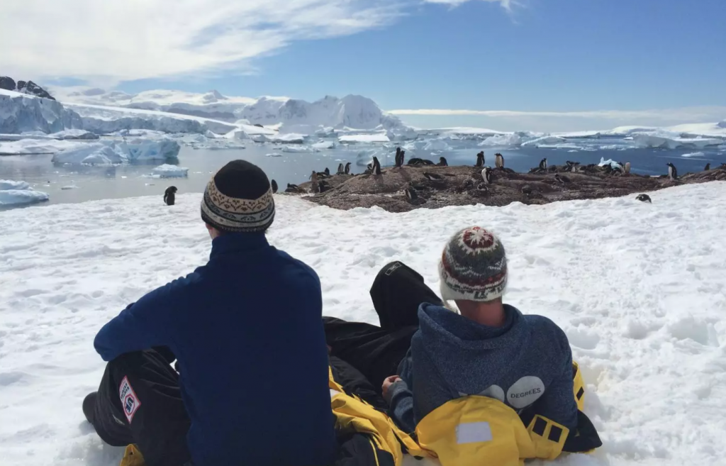
How many countries are there in Antarctica is a pretty simple question to answer because there are none! 7 countries do lay claim to certain parts of the continent for research and scientific purposes. You may also see it referred to as either the White or Frozen continent. It’s not surprising that it’s the coldest place on earth because over 3 quarters of the earth’s ice can be found here. There are no permanent residents in Antarctica but you will find adventurous travellers. Here are some reasons why you should consider visiting Antarctica.
Asia
Number Of Countries: 49
My home! Asia is by far the largest continent on the planet in terms of size (9% of the planet’s surface) and population (4.3 billion, 60% of the world’s population) – with the likes of China, India and Russia located within this continent it’s always going to keep the top spot. If you want to see how many countries in Asia I think there are then check out my article. It can be a bit controversial when deciding which countries are part of Asia and Europe.

Australia (or Australasia)
Number Of Countries: 3
First things first, Australia is a continent and you can also call it Australasia. People are sometimes surprised to hear that the continent only contains 3 countries, that’s because they confuse the continent with the Oceania region. How many countries in Australia varies depends on who you talk to, there are in 14 Australia/Oceania. Check out my article to read my explanation.

Europe
Number Of Countries: 49
It was fun making my list of how many countries are there in Europe, that’s because the continent is part of the same landmass as Asia. I am sure that when you guys read my article not all of you will agree of the countries I include and those that I don’t. Home to nearly 3 quarters of a million people, including me in my Irish youth.

North America
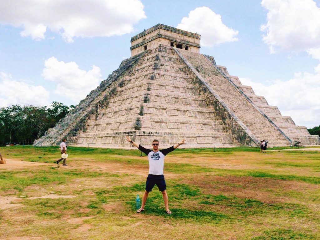
Number Of Countries: 23
North America is a continent that also includes Central America and The Caribbean. How many countries are there in North America is a long-debated topic because some people argue that North and South America are one continent. It’s a huge area with 5 time zones and the only place on the planet with every single type of climate.
If you want to know how many countries in the Caribbean, I blogged that too.
If you want to know how many countries in Central America, I blogged that too.
South America
Number Of Countries: 12
My article about how many countries in South America will show you the 12 countries and lesser-known dependencies which make up the continent. It’s the 4th biggest continent on the planet and an awesome place to visit because you’ll find the Himalayas (Mt. Aconcagua is there which I completed on my mission to climb all 7 peaks), the Amazon river, Angel Falls and much more.

Does everyone agree with 7 Continents in the world??
Nope! Interestingly enough not everyone agrees that there are 7 continents in the world. The reason being that some people combine North and South America because it is one landmass, therefore, should be classed as one continent in their eyes, calling it the ‘American Continent.’
The other contentious issue for a few people is Europe and Asia, some people combine them into one continent calling it ‘Eurasia.’
Why Do Some Say There are 5 or 6 Continents in the world?
TLDR? So why do some people say there are 5 or 6 continents?
North and South America as 1 continent; The Americas
Because they may not separate North and South America as 2 continents, and call it one continent ‘The Americas’.
Europe and Asia as 1 continent; Eurasia
And some include Europe and Asia as 1 continent, calling it Eurasia.
Coming from Ireland, I have only ever been taught that there are 7 continents in the world. I’m pretty sure most of you reading this are the same too. That wasn’t always the case because back in the day people used to be taught that there were 5 continents; Africa, America, Asia, Australia and Europe.
Take a look at the Olympic symbol again. There are 5 rings and that’s because it used to be accepted that there were 5 continents (not separating the 2 Americas and also not including Antarctica). Some countries teach that there are 6 continents in the world; America, Antarctica, Asia, Africa, Australia and Europe (not separating the 2 Americas).

So to confirm, how many continents are there?
I understand why some say 5 and 6 but there are 7 continents in the world. Hope this helps!
Remember, never travel without travel insurance! And never overpay for travel insurance!
I use HeyMondo. You get INSTANT quotes. Super cheap, they actually pay out, AND they cover almost everywhere, where most insurance companies don’t (even places like Central African Republic etc!). You can sign-up here. PS You even get 5% off if you use MY LINK! You can even sign up if you’re already overseas and traveling, pretty cool.
Also, if you want to start a blog…I CAN HELP YOU!
Also, if you want to start a blog, and start to change your life, I’d love to help you! Email me on johnny@onestep4ward.com. In the meantime, check out my super easy blog post on how to start a travel blog in under 30 minutes, here! And if you just want to get cracking, use BlueHost at a discount, through me.
Also, (if you’re like me, and awful with tech-stuff) email me and my team can get a blog up and running for you, designed and everything, for $699 — email johnny@onestep4ward.com to get started.
Do you work remotely? Are you a digital nomad/blogger etc? You need to be insured too.
I use SafetyWing for my digital nomad insurance. It covers me while I live overseas. It’s just $10 a week, and it’s amazing! No upfront fees, you just pay week by week, and you can sign up just for a week if you want, then switch it off and on whenever. You can read my review here, and you can sign-up here!
![]()

So if you’re ready to…..
1) Change your life
2) Travel the world
3) Get paid to travel
4) Create a positive influence on others
5) Be free of offices and ‘real world’ rubbish
Then Sign Up Below and Let’s Get Started!
Question
How many continent do we have.
Grade 1 • Ghana
Answers
7 continents
Teacher • India
We have 7 continents in the world.
The names of the continents are Africa, Antarctica, Asia, Australia/Oceania, Europe, North America, and South America.

Teacher • India
We have seven continents. They are Asia, Australia, Africa, Europe, Antarctica, North and South America.
Asia is the largest continent and Australia is the smallest continent.
Grade 1 • India
we have7 continents
Grade 3 • India
7 Continents are there in our World
Grade 2 • India
There are 7 continents